Los Castillos | |
|---|---|
Municipality and village | |
| Country | |
| Province | Catamarca Province |
| Time zone | UTC−3 (ART) |
Los Castillos is a village and municipality in Catamarca Province in northwestern Argentina. [1]
Los Castillos | |
|---|---|
Municipality and village | |
| Country | |
| Province | Catamarca Province |
| Time zone | UTC−3 (ART) |
Los Castillos is a village and municipality in Catamarca Province in northwestern Argentina. [1]

The Arctic Archipelago, also known as the Canadian Arctic Archipelago, is an archipelago lying to the north of the Canadian continental mainland, excluding Greenland and Iceland.

USS Card was an American Bogue-class escort carrier that saw service in World War II. She was named for Card Sound, a continuation of Biscayne Bay, south of Miami, Florida. She was the flagship of Task Group 21.14 a hunter-killer group formed to destroy German submarines in the North Atlantic.

A pole of inaccessibility with respect to a geographical criterion of inaccessibility marks a location that is the most challenging to reach according to that criterion. Often it refers to the most distant point from the coastline, implying a maximum degree of continentality or oceanity. In these cases, a pole of inaccessibility can be defined as the center of the largest circle that can be drawn within an area of interest without encountering a coast. Where a coast is imprecisely defined, the pole will be similarly imprecise.

Sequoia National Forest is located in the southern Sierra Nevada mountains of California. The U.S. National Forest is named for the majestic Giant Sequoia trees which populate 38 distinct groves within the boundaries of the forest.
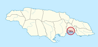
Kingston is one of the 14 Parishes of Jamaica. Together with neighbouring St. Andrew Parish, it makes up the amalgamated Municipal Unit of Kingston and St. Andrew Corporation. The city of Kingston is the parish and national capital.

Leppard Glacier is a large valley glacier draining east between the Aristotle Mountains and Voden Heights, and flowing into Scar Inlet north of Ishmael Peak, on the east coast of Graham Land, Antarctica. The glacier was first seen from the air and photographed in part by Hubert Wilkins on December 20, 1928, and was surveyed by the Falkland Islands Dependencies Survey (FIDS) in 1955. It is now clear that, on the photographic evidence of his outward flight, Wilkins gave the name "Crane Channel" to this glacier, and that on his return flight he photographed what is now accepted as Crane Glacier, perhaps thinking that it was the same feature. Since Crane Glacier has been retained for the northern of these glaciers photographed by Wilkins, the UK Antarctic Place-Names Committee has named this feature for Norman A.G. Leppard, assistant surveyor with the FIDS, who surveyed this area in 1955.

The LuAZ-967 was the Transporter of the Front Line, a small Soviet four-wheel drive amphibious vehicle. Light enough to be air transportable, it had a 400 kg (880 lb) payload over most terrain.
German submarine U-967 was a Type VIIC/41 U-boat of Nazi Germany's Kriegsmarine. Her keel was laid down on 16 May 1942 by Blohm & Voss of Hamburg, Germany. She was commissioned on 11 March 1943 with Oberleutnant zur See Herbert Loeder in command. U-967 commanded by Korvettenkapitän Albrecht Brandi on 5 May 1944 torpedoed USS Fechteler in the Western Mediterranean that was sailing with convoy GUS-38.

Cajapió is a municipality in the state of Maranhão in the Northeast region of Brazil.
Santa Cruz dos Milagres is a municipality in the state of Piauí in the Northeast region of Brazil.
Los Talas (Catamarca) is a village and municipality in Catamarca Province in northwestern Argentina.

Birley Glacier is a glacier, at least 10 nautical miles (19 km) long, flowing west into the eastern extremity of Barilari Bay north of Vardun Point, on the west coast of Graham Land. First seen and roughly surveyed in 1909 by the French Antarctic Expedition under Jean-Baptiste Charcot, it was re-surveyed in 1935–36 by the British Graham Land Expedition (BGLE) under John Rymill, and later named for Kenneth P. Birley, who contributed toward the cost of the BGLE, 1934–37.
Bolton Glacier is a glacier flowing into the head of Briand Fjord, Flandres Bay, on the west coast of Graham Land. It was mapped in 1959 by the Falkland Islands Dependencies Survey from photos taken by Hunting Aerosurveys Ltd in 1956–57, and named by the UK Antarctic Place-Names Committee for William B. Bolton (1848–89), English photographer who, with B.J. Sayce, invented the collodion emulsion process of dry-plate photography in 1864.
Kråsen Crevasse Field is a crevasse field about 15 nautical miles (30 km) long in the lower part of Jutulstraumen Glacier, in Queen Maud Land, Antarctica. It was mapped by Norwegian cartographers from surveys and air photos by the Norwegian–British–Swedish Antarctic Expedition (1949–52) and air photos by the Norwegian expedition (1958–59) and named Kråsen.

Trooz Glacier is an Antarctic glacier. Situated on the Kyiv Peninsula in Graham Land, 1.5 nautical miles (2.8 km) wide at its mouth and some 15 nautical miles (28 km) long, it flows west into the north part of Collins Bay. It was Discovered by the French Antarctic Expedition, 1908–10 and Named for J. de Trooz, Belgian Minister of the Interior and Public Instruction, who was instrumental in procuring funds for the publication of the scientific results of the Belgian Antarctic Expedition, 1897–99. This application was suggested by the Advisory Committee on Antarctic Names (US-ACAN) because of duplication of the name Trooz for what is now known as Cape Perez.
Dodman Island is an island 6.5 km (4.0 mi) long, lying 7.4 km (4.6 mi) south-east of Rabot Island and 18.5 km (11.5 mi) west of Ferin Head, off the west coast of Graham Land, Antarctica. The island was charted and named by the British Graham Land Expedition, 1934–37, under John Rymill.

The Marshall Archipelago is an extensive group of large ice-covered islands within the Sulzberger Ice Shelf off Antarctica. Several of the islands were discovered and plotted by the Byrd Antarctic Expeditions and by the United States Antarctic Service (1939–41), all led by Admiral Richard E. Byrd. The full extent of the archipelago was mapped by the United States Geological Survey from surveys and U.S. Navy air photos (1959–65). The name was proposed by Admiral Byrd for General of the Army George C. Marshall, who made financial contributions as a private individual and also, on the same basis, provided advisory assistance to the Byrd expedition of 1933–35.
German submarine U-332 was a Type VIIC U-boat of Nazi Germany's Kriegsmarine during World War II. She saw service in the Atlantic Ocean and Mediterranean Sea. Built in 1941 and 1942 at Nordsee-Werke, Emden, U-332 was a Type VIIC U-boat, capable of lengthy ocean patrols and of operating in distant environments.

Baily Head is a prominent headland, 160 m high, forming the easternmost extremity of Deception Island, in the South Shetland Islands of Antarctica.
27°58′S65°48′W / 27.967°S 65.800°W
| | This article about a place in Catamarca Province, Argentina is a stub. You can help Wikipedia by expanding it. |
