Related Research Articles

Makassar Strait is a strait between the islands of Borneo and Sulawesi in Indonesia. To the north it joins the Celebes Sea, while to the south it meets the Java Sea. To the northeast, it forms the Sangkulirang Bay south of the Mangkalihat Peninsula. The strait is an important regional shipping route in Southeast Asia.

The Columbia Valley is the name used for a region in the Rocky Mountain Trench near the headwaters of the Columbia River between the town of Golden and the Canal Flats. The main hub of the valley is the town of Invermere. Other towns include Radium Hot Springs, Windermere and Fairmont Hot Springs. The Panorama Ski Resort is located near the valley.
Beaver Glacier is a glacier about 15 miles (24 km) long and 4 miles (6 km) wide, flowing west into Amundsen Bay between Auster Glacier and Mount Gleadell. The head of Beaver Glacier is located very close to the base of Mount King in Enderby Land. It was visited by an Australian National Antarctic Research Expeditions (ANARE) party on October 28, 1956, and named after the Beaver aircraft used by ANARE in coastal exploration.
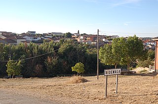
Videmala is a municipality located in the province of Zamora, Castile and León, Spain. According to the 2004 census (INE), the municipality has a population of 216 inhabitants.
Mandialaza is a rural municipality in Madagascar. It belongs to the district of Moramanga, which is a part of Alaotra-Mangoro Region. The population of the municipality was 15835 in 2018.
Texhuacán is a municipality located in the montane central zone in the Mexican state of Veracruz, about 205 km from the state capital Xalapa. It has a surface of 32.90 km2. It is located at 18°37′N97°02′W.

La Serna del Monte is a municipality of the Community of Madrid, Spain.
Saleapaga is a village on the south east coast of Upolu island in Samoa. The village is part of Lepa Electoral Constituency which is within the larger political district of Atua.
Hibbert Rock is a drying rock lying SE of League Rock located in the Quest Channel off the Southern tip of Adelaide Island. Named by the UK Antarctic Place-Names Committee for William Hibbert, ship's Engineer of the RRS John Biscoe (1956) from the late 1950s to 1960s, the ship which assisted the Royal Navy Hydrographic survey Unit in surveying the area between 1962 and 1963.

Saujil (Tinogasta) is a village and municipality in Catamarca Province, in northwestern Argentina. Saujil translates as "illuminated place" in the indigenous Cacán language.
Tranquitas is a village and rural municipality in Salta Province in northwestern Argentina.
On the continent of Antarctica, the Aramis Range is the third range south in the Prince Charles Mountains, situated 11 miles southeast of the Porthos Range and extending for about 30 miles in a southwest–northeast direction. It was first visited in January 1957 by Australian National Antarctic Research Expeditions (ANARE) southern party led by W.G. Bewsher, who named it for a character in Alexandre Dumas' novel The Three Musketeers, the most popular book read on the southern journey.
Natturi is a village in Haljala Parish, Lääne-Viru County, in northeastern Estonia.

Bader Glacier is a small glacier draining the west slopes of Rudozem Heights and flowing to Bourgeois Fjord just south of Thomson Head on German Peninsula, Fallières Coast on the west side of Graham Land, Antarctica.

Usher Glacier is a glacier nearly 4 nautical miles (7 km) long, flowing northwest into the sea between Stigant Point and Davey Point on the north coast of King George Island, in the South Shetland Islands. Named by the United Kingdom Antarctic Place-Names Committee (UK-APC) in 1960 for J. Usher, Master of the Caraquet from Liverpool, who visited the South Shetland Islands in 1821–22.

Turner Glacier is a glacier on the east side of Mount Liotard flowing northeast into Ryder Bay, Adelaide Island. The glacier was surveyed by Falkland Islands Dependencies Survey (FIDS), 1948, and photographed from the air by Falkland Islands and Dependencies Aerial Survey Expedition (FIDASE), 1956–57. Named by the United Kingdom Antarctic Place-Names Committee (UK-APC) in 1977 after Andrew John Turner, British Antarctic Survey (BAS) builder, Halley Station, 1973–74; Signy Island, 1974–75; Rothera Station, 1976–77, 1978–80; and Faraday Station, 1982–83.

Moreton Point is a point 1 nautical mile (2 km) north of Return Point at the western end of Coronation Island, in the South Orkney Islands off Antarctica. It was roughly charted by Captains George Powell and Nathaniel Palmer in 1821, and was named by Discovery Investigations personnel on the Discovery II who charted the islands in 1933.
Hessler Peak is a sharp peak, 1,670 metres (5,480 ft) high, at the south end of Dunbar Ridge in the Heritage Range in Antarctica. It was mapped by the United States Geological Survey from surveys and U.S. Navy air photos from 1961 to 1966, and was named by the Advisory Committee on Antarctic Names for Victor P. Hessler, an ionosphere physicist and United States Antarctic Research Program scientist at the Soviet Vostok Station in the 1965–66 and 1966–67 summer seasons.
References
- ↑ Ministerio del Interior (in Spanish)

28°02′S67°37′W / 28.033°S 67.617°W
| | This article about a place in Catamarca Province, Argentina is a stub. You can help Wikipedia by expanding it. |