Puerta de Corral Quemado | |
|---|---|
Municipality and village | |
| Country | |
| Province | Catamarca Province |
| Time zone | UTC−3 (ART) |
Puerta de Corral Quemado is a village and municipality in Catamarca Province in northwestern Argentina. [1]
Puerta de Corral Quemado | |
|---|---|
Municipality and village | |
| Country | |
| Province | Catamarca Province |
| Time zone | UTC−3 (ART) |
Puerta de Corral Quemado is a village and municipality in Catamarca Province in northwestern Argentina. [1]

USS Card was an American Bogue-class escort carrier that saw service in World War II. She was named for Card Sound, a continuation of Biscayne Bay, south of Miami, Florida. She was the flagship of Task Group 21.14 a hunter-killer group formed to destroy German submarines in the North Atlantic.

Rocky promontory or Punta Cuatro Romano or Roman Figure Four Mountain or Roman Four Rock is a cliff/promontory, rising to 830 m, marking the north side of the entrance to Neny Fjord on the west coast of Graham Land. Roman Four Promontory is located at 68°13′S66°56′W and has an elevation of 830 m. Roman Four Promontory was first charted by the British Graham Land Expedition (BGLE) (1934–1937) under John Riddoch Rymill. The name was given by members of East Base of the United States Antarctic Service (USAS) Expedition (1939–1941), whose base was located on nearby Stonington Island, and derives from snow-filled clefts along the face of the promontory giving the appearance of a Roman numeral IV.
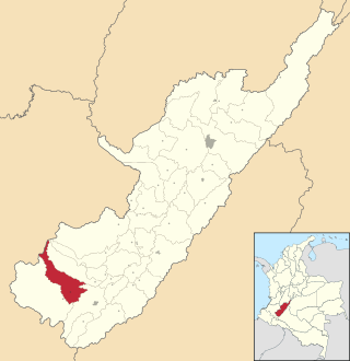
Isnos is a town and municipality in the Huila Department, Colombia. This region was struck with a M7.3 earthquake on 30 September 2012. Isnos was recognized and declared by UNESCO in 1995 as a Cultural and Historical Heritage.

Cabezón de la Sierra is a municipality located in the province of Burgos, Castile and León, Spain. According to the 2004 census (INE), the municipality has a population of 67 inhabitants.
Andilanatoby is a rural municipality in Madagascar. It is situated at 55 km south-east of Ambatondrazaka and also belongs to the district with the same name: Ambatondrazaka, which is a part of Alaotra-Mangoro Region. The population of the commune was estimated to be approximately 22,000 in 2001 commune census.
The Melchior River is a river of the Federal District in central Brazil.
Várzea Branca is a municipality in the state of Piauí in the Northeast region of Brazil.
Siján is a village and municipality in Catamarca Province in northwestern Argentina.
Chichinales is a village and municipality in Río Negro Province in Argentina.
The Bayard Islands are a small group of islands lying 1.6 km (1 mi) northeast of Cape Willems, off the west coast of Graham Land. They were charted by the Belgian Antarctic Expedition under Gerlache, 1897–99, and named by the UK Antarctic Place-Names Committee in 1960 for Hippolyte Bayard, a French civil servant who, in 1839, independently invented a photographic process for obtaining direct positives on paper.
Centurion Glacier is a small steep glacier flowing northwest to Neny Bay between Mount Nemesis and Roman Four Promontory, on the west coast of Graham Land.
Cetus Hill is a large ice-covered mound which comes to a point with three jagged rock peaks at its west end. It is located at the head of Ryder Glacier in western Palmer Land, about 27 nautical miles (50 km) east-northeast of Gurney Point. It was named by the UK Antarctic Place-Names Committee after the constellation of Cetus.

Swithinbank Glacier is a glacier on the west side of Hemimont Plateau flowing north to the southeast corner of Square Bay, in Graham Land. Mapped by Falkland Islands Dependencies Survey (FIDS) from surveys and air photos, 1946–59. Named by United Kingdom Antarctic Place-Names Committee (UK-APC) for Charles Swithinbank, British glaciologist, a participant in several British, New Zealand and American expeditions to Antarctica, 1949–62.
Goldsmith Glacier is a glacier flowing west-northwest through the Theron Mountains of Antarctica, 6 nautical miles (11 km) south of Tailend Nunatak. It was first mapped in 1956–57 by the Commonwealth Trans-Antarctic Expedition (CTAE) and named for Rainer Goldsmith, medical officer with the advance party of the CTAE in 1955–56.
Mink Peak is a prominent peak standing 2 nautical miles (4 km) north of Cleveland Mesa, at the east end of the Watson Escarpment in Antarctica. It was mapped by the United States Geological Survey from surveys and U.S. Navy air photos, 1960–64, and was named by the Advisory Committee on Antarctic Names for Harold D. Mink, a utilitiesman with the wintering parties at Byrd Station in 1962 and 1966.
Cape McNab is a cape, 350 metres (1,150 ft) high, which forms the south end of Buckle Island in the Balleny Islands of Antarctica. It was named for John McNab, second mate of the schooner Eliza Scott, who made a sketch of the Balleny Islands when they were discovered by John Balleny in 1839.
Clarke Glacier is a 2 miles (3.2 km)-wide, 20 miles (32 km)-long glacier, located on the west coast of Graham Land in Antarctica. It flows west, along the north side of Sickle Mountain and the Baudin Peaks, to Mikkelsen Bay.
27°14′S66°56′W / 27.233°S 66.933°W
| | This article about a place in Catamarca Province, Argentina is a stub. You can help Wikipedia by expanding it. |
