
Dragontail Peak, also known as Dragon Tail, is a mountain in the Stuart Range, in Chelan County, Washington. While climbing an adjacent peak, Lex Maxwell, Bob McCall, and Bill Prater remarked that the needles on the crest, southwest of the summit, resembled a "dragon tail". The name was officially accepted in 1955. On the mountain's northeast flank lies Colchuck Lake which drains into Mountaineer Creek, and Colchuck Glacier lies below the western slopes of the peak. On its south side the mountain drops steeply to Ingalls Creek, which flows about 5,800 feet (1,800 m) below the summit.

Bonanza Peak is a tall peak in the North Cascades in the U.S. state of Washington and the Glacier Peak Wilderness of the Wenatchee National Forest. At 9,516 feet (2,900 m) in elevation, it is the highest point in Chelan County, and the highest non-volcanic peak in Washington. and the Cascade Range as a whole. Bonanza Peak's prominence is 3,711 feet (1,131 m), making it the 26th most prominent peak in Washington. The nearest higher peak is Glacier Peak, 14.4 miles (23.2 km) to the southwest.

Buckner Mountain is a tall peak in the North Cascades of Washington state and in the Stephen Mather Wilderness of North Cascades National Park. At 9,114 feet (2,778 m) in elevation it is the highest in Skagit County and one of about ten of Washington's non-volcanic peaks above 9,000 feet high. It is ranked as the 14th highest peak in the state, and the third highest peak in North Cascades National Park.

Spider Mountain is an 8,317-foot (2,535-metre) mountain summit located in the Glacier Peak Wilderness in western Chelan County of Washington state. It is part of the North Cascades, which is a subset of the Cascade Range. Meltwater from the Spider Glacier on the steep north face, and other surface runoff from the mountain drains into Flat Creek, which is a tributary of the Stehekin River. Topographic relief is significant as the summit rises 4,200 feet above West Fork Flat Creek in one mile (1.6 km). The nearest higher neighbor is Mount Formidable 1.5 miles (2.4 km) to the west. The Middle Cascade Glacier lies between these two mountains and the Ptarmigan Traverse passes between the two.

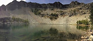
Colchuck Peak is an 8,705-foot (2,653-metre) mountain summit located in the Stuart Range, in the Alpine Lakes Wilderness in Chelan County of Washington state. The nearest higher peak is Dragontail Peak, 0.49 mi (0.79 km) to the east, and Argonaut Peak lies 0.9 mi (1.4 km) to the southwest. The Colchuck Glacier which lies on the northeast slopes of the peak melts into Colchuck Lake. The mountain and glacier take their name from the lake, which in Chinook jargon means "cold water". Precipitation runoff from the peak drains north into Mountaineer Creek, a tributary of Icicle Creek, or south into Ingalls Creek, all of which winds up in the Wenatchee River. Colchuck Peak is more notable for its steep rise above local terrain than for its absolute elevation as topographic relief is significant with the summit rising 3,130 feet (954 m) above Colchuck Lake in 1 mi (1.6 km), and 4,600 feet (1,402 m) above Ingalls Creek in 1.9 mi (3.1 km).

Tupshin Peak is an 8,347-foot (2,544-metre) mountain summit located in the Glacier Peak Wilderness of the North Cascades in Washington state. The mountain is situated in Chelan County, on land managed by Wenatchee National Forest. The nearest higher neighbor is Devore Peak, 1.55 mi (2.49 km) to the south-southwest, and Bonanza Peak lies 6.71 mi (10.80 km) to the southwest. Precipitation runoff from the peak drains to nearby Lake Chelan via tributaries of the Stehekin River. The mountain's name comes from Chinook jargon and means "needle".

Glory Mountain is a 7,228-foot (2,203-metre) mountain summit located in the North Cascades Range in Chelan County of Washington state. Glory Mountain is situated southeast of Trapper Lake on the shared border of North Cascades National Park and Glacier Peak Wilderness. The nearest higher peak is Trapper Mountain, 1.72 miles (2.77 km) to the west. Precipitation runoff from the mountain drains into Cottonwood Creek and Flat Creek, both tributaries of the Stehekin River. An unofficially named secondary peak called Halleluja Peak 7,120+ ft lies 0.32 miles (0.51 km) to the west of the summit.

Devore Peak is an 8,382-foot (2,555-metre) mountain summit located in the Glacier Peak Wilderness of the North Cascades in Washington state. The mountain is situated in Chelan County, on land managed by Wenatchee National Forest. Its nearest higher peak is Martin Peak, 3.36 mi (5.41 km) to the southwest, and Tupshin Peak lies 1.55 mi (2.49 km) to the north-northeast. Precipitation runoff from the peak drains to nearby Lake Chelan via tributaries of the Stehekin River and Devore Creek.

Copper Peak is an 8,965-foot (2,733-metre) mountain summit located in the Entiat Mountains, a sub-range of the North Cascades, in Chelan County of Washington state. Copper Peak is situated 80 miles northeast of Seattle in the Glacier Peak Wilderness, on land managed by the Wenatchee National Forest. Copper Peak ranks 21st-highest on Washington's highest 100 peaks, and 19th on the "Bulger List." The nearest higher neighbor is Mount Fernow, 0.88 miles (1.42 km) to the south. Precipitation runoff from the mountain and meltwater from the glacier on the southeast slope drains into nearby Lake Chelan via Railroad Creek. The first ascent of the peak was made in August 1937 by Franklin Bennet, Edgar Courtwright, and Toivo Hagman. The peak's toponym refers to an abandoned copper mine that once operated at the northeast base of the peak.

McGregor Mountain is an 8,143-foot (2,482-metre) elevation massif located in the Stehekin Valley of the North Cascades, in Chelan County of Washington state. McGregor Mountain is situated northwest of Lake Chelan in the northern Methow Mountains, on the shared border of North Cascades National Park and Lake Chelan National Recreation Area. The closest community is Stehekin, and the nearest higher neighbor is Goode Mountain, 7.3 miles (11.7 km) to the northwest. Precipitation runoff from the mountain drains into tributaries of the Stehekin River. Topographic relief is significant since the southern aspect of the mountain rises 6,600 feet above this river in approximately two miles. The famous Pacific Crest Trail traverses the western base of this mountain, and the strenuous 7.7-mile (12.4 km) McGregor Mountain Trail gains 6,400 feet of elevation to take hikers within a half-mile of the summit. Reaching the summit requires exposed scrambling the final 1,100 feet, and an ice axe is needed if the trail remains covered by snowpack. The summit was the site of an old fire lookout cabin from 1923 until 1955, but now has a radio repeater for the National Park Service. The views from the top include Glacier Peak, Black Peak, Corteo Peak, Frisco Mountain, Tupshin Peak, Dome Peak, Glory Mountain, and many others. This mountain was named for Billy McGregor, a Stehekin Valley resident who had a cabin and homestead at the base of this mountain during the 1890s. In May 1901, Billy disappeared overnight from a boat docked in Lake Chelan, and was never seen or heard from again.

Bearcat Ridge is an 8,033-foot (2,448-metre) mountain ridge located in the Chelan Mountains, in Chelan County of Washington state. It is situated on the boundary of Glacier Peak Wilderness, on land managed by Wenatchee National Forest. Its nearest higher neighbor is Emerald Peak, 1.1 mi (1.8 km) to the south-southwest, and Cardinal Peak is positioned 1.76 mi (2.83 km) to the south. Precipitation runoff from the ridge drains into nearby Lake Chelan via Emerald Creek and Bearcat Creek. Bearcat Ridge forms the high divide between these two creek valleys.
Martin Peak is an 8,509-foot (2,594-metre) mountain summit located in the North Cascades, in Chelan County of Washington state. Martin Peak is situated 80 miles northeast of Seattle, and 3 mi (4.8 km) northwest of Holden, in the Glacier Peak Wilderness, on land managed by the Wenatchee National Forest. Martin Peak ranks 57th on Washington's highest 100 peaks, and 54th on the "Bulger List". The nearest higher neighbor is Bonanza Peak, 2.35 miles (3.78 km) to the west, and Riddle Peak lies 3.7 miles (6.0 km) to the east-southeast. Precipitation runoff from the mountain and meltwater from the glacier in the east cirque drains into nearby Lake Chelan via Railroad Creek and Company Creek. Topographic relief is significant since the southern aspect of the mountain rises 4,900 feet above the Railroad Creek Valley in approximately two miles (3.2 km). The first ascent of the peak was made in July 1936 by Ida Zacher Darr.

Riddle Peaks, also known as Riddle Peak, is an 8,212-foot (2,503-metre) mountain summit located at the head of Riddle Creek in the North Cascades, in Chelan County of Washington state. Riddle Peak is situated on the Glacier Peak Wilderness boundary, six miles west of Lake Chelan, and 2.5 mi (4.0 km) northeast of Holden, on land managed by the Wenatchee National Forest. The nearest higher neighbor is Flora Mountain, 2.25 miles (3.62 km) to the northeast, and Martin Peak lies 3.7 miles (6.0 km) to the west-northwest. Precipitation runoff from the mountain drains into Lake Chelan via Railroad Creek, Riddle Creek, and Devore Creek. Topographic relief is significant since the southern aspect of the mountain rises 5,000 feet above the Railroad Creek valley in approximately 2 mi (3.2 km). The first ascent of the peak was made September 11, 1940, by Everett and Ida Zacher Darr, Joe Leuthold, and Eldon Metzger via an easy ridge from Tenmile Pass.

Mount Howard is a prominent 7,063 feet (2,153 m) mountain summit located west of Lake Wenatchee in Chelan County of Washington state. Mount Howard is the highest point of Nason Ridge, and is 1.37 mi (2.20 km) northeast of Rock Mountain, which is second-highest. This peak is set approximately midway between Stevens Pass and Lake Wenatchee, on land managed by the Okanogan–Wenatchee National Forest. Precipitation runoff from the peak drains into tributaries of the Wenatchee River. The mountain may have been named by a survey party, and first published in 1887.

Chilly Peak is a 7,970-foot (2,429-metre) mountain summit located in the Entiat Mountains, a sub-range of the North Cascades, in Chelan County of Washington state. It ranks as 194th of Washington's highest 200 peaks. The nearest higher neighbor is Ice Box, 1.3 miles (2.1 km) to the northwest, and Spectacle Buttes are set 2.1 miles (3.4 km) to the north-northeast. Chilly Peak is situated 2.5 miles (4.0 km) south of Ice Lakes in the Okanogan–Wenatchee National Forest. Precipitation runoff from the mountain drains east into Ice Creek which is a tributary of the Entiat River, and west into Rock Creek, a tributary of the Chiwawa River.

Arrowhead Mountain is a 6,030 ft (1,840 m) mountain summit located in Chelan County of Washington state. It is situated 6 mi (9.7 km) east of Stevens Pass, on the boundary of Alpine Lakes Wilderness, on land managed by the Okanogan–Wenatchee National Forest. Arrowhead Mountain is part of the Chiwaukum Mountains, which are a subset of the Cascade Range. Its nearest higher neighbor is Jim Hill Mountain, 2.5 mi (4.0 km) to the southwest. Precipitation runoff from the peak drains into tributaries of Nason Creek, which in turn is a tributary of the Wenatchee River. This mountain was named by Albert Hale Sylvester (1871–1944), a pioneering surveyor, explorer, topographer, and forest supervisor who named hundreds of natural features in the Cascades.

White Goat Mountain is a 7,800+ ft mountain summit located in the Glacier Peak Wilderness of the North Cascades in Washington state. The mountain is situated in Chelan County, on land managed by Wenatchee National Forest. Its nearest higher neighbor is Tupshin Peak, 0.7 mi (1.1 km) to the northeast, and Devore Peak is 1.02 mi (1.64 km) to the south. Precipitation runoff from the peak drains to nearby Lake Chelan via Company and Devore Creeks. The first ascent was made September 10, 1940, by Everett and Ida Zacher Darr, Joe Leuthold, and Eldon Metzger. A herd of mountain goats beneath the peak was their inspiration for so naming this geographical feature.

Le Conte Mountain is a 7,762-foot-elevation (2,366-meter) summit located on the shared boundary of Skagit County and Chelan County in Washington state. It is positioned on the crest of the North Cascades Range, and is set within the Glacier Peak Wilderness. Le Conte Mountain is situated on the shared border of Mount Baker-Snoqualmie National Forest and Okanogan-Wenatchee National Forest. Access to the peak is via the Ptarmigan Traverse. The nearest higher neighbor is Sentinel Peak, 1.87 miles (3.01 km) to the south-southeast, and Spider Mountain is 2.4 miles (3.9 km) to the northeast. The Le Conte Glacier and South Cascade Glacier lie to the south of the peak. Precipitation runoff on the east side the mountain drains into Flat Creek which is a tributary of the Stehekin River, while precipitation drains into headwaters of the South Fork Cascade River from the west side. Topographic relief is significant as the southwest aspect rises nearly 2,500 feet above South Cascade Lake in less than one-half mile, and the northeast aspect rises 3,200 feet above Flat Creek in one mile.
Mount Bigelow is an 8,449-foot-elevation (2,575-meter) mountain summit located on the border shared by Okanogan and Chelan counties in Washington state.

Thor Peak is a 6,804-foot-elevation (2,074-meter) mountain summit in Chelan County, Washington, United States.


