Catlow Valley

Last updated

Catlow Valley
Catlow Valley (Harney County, Oregon scenic images) (harDA0168).jpg
The Catlow Valley from Catlow Valley Road
USA Oregon location map.svg
Red pog.svg
Catlow Valley
Floor elevation4,554 ft (1,388 m)
Length50 mi (80 km)north–south
Width30 mi (48 km)east–west
Area1,300 sq mi (3,400 km2)
Geography
CountryUnited States
State Oregon
Region Basin and Range Province
County Harney
Borders on
Coordinates 42°33′49″N119°03′30″W / 42.5634968°N 119.0582564°W / 42.5634968; -119.0582564 [1]

The Catlow Valley is a basin in Harney County, Oregon, United States. [1] It is a remote valley at the northwestern corner of North America's Basin and Range Province. The valley is named after a pioneer rancher, John Catlow. The area was used by Native Americans for thousands of years before European explorers arrived in the 19th century. Today, cattle ranching is the main commercial activity in the valley. The public land in the Catlow Valley is administered by the Bureau of Land Management. This public land offers a number of recreational opportunities including hiking, hunting, fishing, bird watching, and wildlife viewing.

Contents

Geography

Catlow Valley is located in Harney County in southeastern Oregon. The area is the northwestern corner of North America's continental basin and range country. The valley is approximately 50 miles (80 km) long and 30 miles (48 km) wide. It covers approximately 1,300 square miles (3,400 km2) of high desert range land. [2] The average elevation of the valley floor is 4,500 feet (1,400 m) above sea level. [2] [3]

The Catlow Valley is bounded by Hart Mountain on the west and Steens Mountain on the east, and Beatys Butte is southwest of the valley. Warner Peak is the highest point on Hart Mountain. The summit of Warner Peak is 8,012 feet (2,442 m) above sea level. [4] From the crest of the Hart Mountain, the land slopes gently down to the floor of the valley. [5] Steens Mountain's western boundary is Catlow Rim. The rim runs along the east side of Catlow Valley from north to south. At the north end of the valley, the rim begins as gentle rolling hills. The rim gets steeper and high as it runs south. At the south end of the valley, Catlow Rim has a cliff face that rises more than a 1,000 feet (300 m) above the valley floor. [6] [7] Beatys Butte is a stand-alone peak southwest of Catlow Valley. Its summit is 7,918 feet (2,413 m) above sea level, which gives it a 3,400-foot (1,000 m) prominence above the valley floor. [8]

Geology

Rainbow over Catlow Rim escarpment Catlow Rim, Harney County, Oregon.jpg
Rainbow over Catlow Rim escarpment

The Catlow Valley is a tectonic depression called a graben. [2] It is bounded on the east and west by high, uplifted fault-block mountains—Hart Mountain to the west and Steens Mountain to the east [2] —with which it forms a horst and graben geological feature. Catlow Rim is a prominent escarpment that forms the western face of the Steens Mountain fault block, overlooking the Catlow Valley. [2] [9] The rim is a basalt cliff that runs along the east side of the valley. Catlow Cave is located at the base of Catlow Rim near the southern end of the valley. The cave is 130 feet (40 m) wide at its mouth. It is 50 feet (15 m) high and 60 feet (18 m) deep. Roaring Springs Cave is another prominent cave located at the base of Catlow Rim. [2] [10]

During the Pleistocene Epoch, the Catlow Valley was covered by a single large lake, approximately 50 miles (80 km) by length and width. In some spots, the lake was over 250 feet (76 m) deep. Today, the valley is a high-desert alluvial basin. However, evidence of the ancient lake can still be seen in the form of shoreline erosion marks, gravel bars, and wave-cut terraces around the edge of the valley, especially along the base of Catlow Rim. [2] [9] [11]

Climate

The climate in the Catlow Valley is typical of the high-desert country of southeastern Oregon. Summers in the valley are short, characterized by high temperatures and very little moisture. The valley gets an average of 9 inches (23 cm) of precipitation per year, mostly as snowfall. The winters are cold. [8]

Climate data for P Ranch Refuge, Oregon (the nearest weather station to the Catlow Valley)
MonthJanFebMarAprMayJunJulAugSepOctNovDecYear
Mean daily maximum °F (°C)41.4
(5.2)
46.7
(8.2)
55.2
(12.9)
61.4
(16.3)
68.0
(20.0)
76.5
(24.7)
87.2
(30.7)
86.6
(30.3)
78.5
(25.8)
66.2
(19.0)
49.7
(9.8)
41.3
(5.2)
63.2
(17.3)
Daily mean °F (°C)31.2
(−0.4)
34.4
(1.3)
41.2
(5.1)
46.3
(7.9)
52.7
(11.5)
59.5
(15.3)
66.8
(19.3)
65.2
(18.4)
57.2
(14.0)
48.7
(9.3)
37.0
(2.8)
29.9
(−1.2)
47.5
(8.6)
Mean daily minimum °F (°C)20.9
(−6.2)
22.1
(−5.5)
27.1
(−2.7)
31.2
(−0.4)
37.4
(3.0)
42.5
(5.8)
47.3
(8.5)
43.8
(6.6)
36.0
(2.2)
31.3
(−0.4)
24.4
(−4.2)
18.5
(−7.5)
31.9
(−0.1)
Source: National Oceanic and Atmospheric Administration, National Climatic Data Center normals data, 1981–2010 [12]

There is no official weather reporting station in the Catlow Valley. The P Ranch weather station is the nearest official National Oceanic and Atmospheric Administration (NOAA) reporting station to the valley. It is approximately 5 miles (8.0 km) northeast of the Catlow Valley in the neighboring Blitzen Valley. The elevation of the P Ranch weather station is 4,210 feet (1,280 m) above sea level, approximately 300 feet (91 m) lower than the average elevation of the Catlow Valley. It reports daily weather data to NOAA's National Climatic Data Center. [12]

Ecology

Flora

Home Creek riparian area Home Creek in Catlow Valley, Oregon.jpg
Home Creek riparian area

The Catlow Valley topography provides a number of wildlife habitats. These include seasonal lakes, marshes, riparian areas, grasslands, sage steppe, dry juniper forests, and rimrock. The valley is predominantly high-desert grassland with gently rolling hills to the north, west, and south of the valley floor. There are wetlands and meadows at the mouth of canyons where runoff from Hart Mountain and Steens Mountain drains into the valley. There are two major drainages from Hart Mountain on the west side of the valley, Rock Creek and Guano Creek. Rock Creek enters the valley from the northwest, and Guano Creek flows in from the southwest. The east side of the valley is bounded by Catlow Rim, a steep and rugged cliff. The rim is cut by canyons that channel runoff into small man-made reservoirs and shallow natural marshes along the edges of the valley floor. The three main drainages on the east side of the valley are Home Creek, Threemile Creek, and Skull Creek. [2] [13] [14] On the east side of the valley, Catlow Rim provides a rimrock habitat. [15] Some of the east slope of Hart Mountain and the west slope of Steens Mountain are lightly covered with western juniper. There are also aspen trees in areas where winter snow tends to accumulate, as well as a ponderosa pine grove in one area on Hart Mountain. [5]

The dominant vegetation throughout most of the valley is big sagebrush, low sagebrush, rabbitbrush, and bitterbrush. Common grasses include bluebunch wheatgrass, bunchgrass, and Idaho fescue. [9] [15] In addition, greasewood, shadscale, spiny hopsage, winterfat, and basin wildrye can be found in parts of the valley. [16]

Fauna

The Catlow Valley's wildlife includes many high-desert animal species. Large mammals found in the valley include mule deer, pronghorn, bighorn sheep, coyotes, bobcats, and cougars. The valley is also home to a herd of wild horses. Smaller mammals include badgers, jackrabbits, antelope squirrels, least chipmunks, bushy-tailed woodrats, desert woodrats, Great Basin pocket mice, canyon mice, and long-eared myotis bats. [8] [15] [16] [17] Among the common reptiles are Great Basin fence lizards, sagebrush lizards, desert horned lizards, western skinks, gopher snakes, and western rattlesnakes. [8] [16] [18]

Pronghorn in a Catlow Valley field Pronghorn in Catlow Valley, Oregon.jpg
Pronghorn in a Catlow Valley field

In the sage steppes and grasslands of the Catlow Valley, resident birds include horned larks, Brewer's sparrows, vesper sparrows, sage thrashers, sagebrush sparrows, black-throated sparrows, common ravens, and greater sage grouse. The valley also hosts mountain chickadees, Cassin's finches, black-headed grosbeaks, green-tailed towhees, yellow-rumped warblers, MacGillivray's warblers, mountain bluebirds, white-headed woodpeckers, California quail, mourning doves, magpies, burrowing owls, flammulated owls, and northern harriers. In the valley's riparian areas, dusky flycatchers, yellow warblers, orange-crowned warblers, house wrens, and spotted towhees are common in the summer months. In the rimrock, there are chukars, white-throated swifts, cliff swallows, and barn swallows. The larger birds include great horned owls, long-eared owls, prairie falcons, American kestrels, red-tailed hawks, and golden eagles. [8] [15] [19]

All five of the year-round creeks that flow into the Catlow Valley (Rock Creek, Guano Creek, Home Creek, Skull Creek, and Threemile Creek) support fish populations. The native fish are tui chub, Lahontan cutthroat trout, and Great Basin redband trout. The creeks also host introduced populations of rainbow trout. Redband trout and tui chub are abundant and well-distributed throughout the Rock Creek habitat. In Home Creek, the redband distribution and abundance are moderate; portions of the habitat are degraded. The redband populations in Guano, Skull, and Threemile creeks are limited. In addition, degraded parts of the Threemile Creek habitat include Threemile Reservoir. [20] [21]

History

Early history

Skull Creek dunes archaeological site Archaeologist in Catlow Valley, Oregon.jpg
Skull Creek dunes archaeological site

Native Americans used the Catlow Valley for thousands of years before the first European explorers arrived. The valley has a number of petroglyph sites. Some of these petroglyphs may be up to 12,000 years old. [11] [22] When he first excavated Catlow Cave in 1934, archaeologist Luther S. Cressman found evidence of Native American habitation dating back to the Paleo-Indian period (8,000 to 12,000 years ago) as well as artifacts from the Early Archaic period (6,000 to 8,000 years ago). Cressman identified four rock fire pits and other housekeeping features within Catlow Cave. Later excavations found stone tools, baskets, woven mats, sandals, rope, and fragments of leather. [10] [23] The Skull Creek dunes are another archaeological site that provides evidence of early Native American habitation in the Catlow Valley. That site documents at least 8,000 years of occupation. [24] Prior to the arrival of white settlers, the Catlow Valley area was occupied by the Northern Paiute people. [2]

19th century

The first European explorer to enter the valley may have been John Work, who headed a Hudson's Bay Company trapping expedition that explored the area in 1831. While it is not certain that he visited the Catlow Valley, Work is known to have passed through the Steens Mountain area as well as the neighboring Warner Valley, west of Hart Mountain. [25]

In 1864, Lieutenant Colonel Charles S. Drew of the 1st Oregon Cavalry passed just south of the Catlow Valley while on a long-range reconnaissance patrol for the United States Army. Drew named Beatys Butte in honor of Sergeant A. M. Beaty, one of the noncommissioned officers in his party. [26]

In 1865, the United States Army decided that it needed a fort in southeastern Oregon to facilitate the interdiction of Indian raiding parties passing through the area. In 1866, a detachment from Fort Boise was sent to establish the fort. The soldiers arrived on the east side of Warner Valley in late summer. Unable to cross the valley's long chain of lakes and marshes, the soldiers built a winter camp on the east slope of Hart Mountain, overlooking the Catlow Valley. This outpost was called Camp Warner (later known as Old Camp Warner). The camp was sited poorly, and the men had a very difficult winter. In February 1867, General George Crook visited the outpost. Citing the camp's poor location, Crook ordered that the post be moved to the west side of the Warner Valley. When the new camp was finished in July 1867, Old Camp Warner was abandoned. Today, all that remains of Old Camp Warner is two military graves. [27] [28] [29]

In 1865, the United States Congress authorized the construction of the Oregon Central Military Wagon Road from Eugene, Oregon, to Fort Boise in Idaho. Congress allowed the construction company to claim three sections of land for every mile of road built. As a result, road surveyors laid out a route designed to pass through as much well-watered land as possible. The route of the military road came through the Warner Valley, passed south of Hart Mountain through what is today the Hart Mountain National Antelope Refuge, and then east through the Catlow Valley. However, the road was little more than a trail, and it was rarely used. [30] [31]

Cattle ranchers began using the Catlow Valley in the latter part of the 19th century. The first to arrive was Peter French in 1872, locating one of his five ranches in the valley. Another cattle rancher, John Catlow, followed in 1874. Catlow never owned land in the valley, but he grazed cattle there in the mid-1870s. David Shirk, one of Catlow's foremen, named the valley after his boss. [2] [32] [33] [34] Shirk was soon joined by his brother, William. In 1876, the two Shirk brothers established a ranch in the Catlow Valley, near water sources around Home and Threemile creeks. This put the Shirk brothers at odds with French, who already controlled much the valley's water. In 1889, David Shirk killed one of French's ranch hands in a dispute over water rights. While a jury decided it was self-defense, the Shirk brothers moved their main ranch to a location south of Beatys Butte to minimize future conflict with French and his employees. [35]

20th century

Unincorporated town of Blitzen Town of Blitzen, Oregon, in the Catlow Valley on the west side of Steens Mountain (3387914198).jpg
Unincorporated town of Blitzen

In the early 1900s, a surge of dry-land farmers arrived in the Catlow Valley. They were drawn by the prospect of free land offered by the federal government's Homestead Act. People's interest in the area was increased by newspaper articles promising that a railroad would soon be built through the valley. [2] [36] [37] By 1916, there were over 700 settlers living in the Catlow Valley. To support these settlers, small unincorporated communities were established across the valley. These sites included Beckley, Delaine, Catlow, Berdugeo, Sageview, Tiara, and Blitzen. Most of these sites were little more than a general store with an attached post office. [38]

Beckley was founded in 1911 as a single store. A post office was added the following year. The Beckley post office remained open for 14 years, closing in 1926. [39] Delaine was located at the west edge of the valley on a lower slope of Hart Mountain, in Lake County. Its post office was opened in 1912, then closed exactly one year later. [40] The Catlow post office was opened in 1914 and remained open until 1923. [32] The Berdugo post office was opened near the Roaring Springs Ranch in 1915. It closed two years later. [41] Sageview was located on the west side of the valley. A post office was the only building at the site. The post office was opened in 1916 and closed in 1918. [42] The Tiara post office was open from May 1916 to January 1917. [43]

The largest and oldest community in the Catlow Valley was Blitzen. Its post office was opened in 1916. However, there were only three families left in Blitzen in 1924. By 1928, there were fewer than 100 people living in the entire valley. The Blitzen post office continued to operate as a small rural delivery site until it was closed in 1943. [2] [44] [45] [46] Today, there is no evidence of habitation at any of these sites except at the ghost town of Blitzen, where there are still a few deteriorated buildings at the town site. [47]

Human activity

Today, there are no incorporated towns or unincorporated communities in the Catlow Valley, but only a few scattered ranches. Agriculture is the primary source of income for those living in the valley. Much of the private land in the valley is used to grow winter feed for local cattle herds. Wells provide groundwater for large irrigation circles and pipe irrigation systems in the valley. Because of the short growing season, the valley's principal crops are wild hay and alfalfa. [2] [48]

The largest ranch in the Catlow Valley is the Roaring Springs Ranch. It includes 260,000 acres (1,100 km2) of deeded property plus grazing rights on an additional 800,000 acres (3,200 km2) of public land. The ranch is located below Catlow Rim, where a large spring gushes from fissures in the rim wall. The spring feeds numerous ponds and meadows, providing habitat for wildlife as well as productive range land for cattle. The ranch has 20,000 acres (81 km2) of irrigated meadow lands that produce 200 short tons (180 metric tons) of alfalfa each year. [34] [49] The ghost town of Blitzen is located on property owned by the ranch. [47] In 2007, the Roaring Springs Ranch won the Environmental Stewardship Award sponsored by the National Cattlemen's Beef Association and the United States Department of Agriculture. [50]

All of the public land in the Catlow Valley is administered by the Bureau of Land Management (BLM). These public lands offer a number of recreational opportunities including hiking, hunting, fishing, bird watching, wildlife viewing, photography, and camping. Among the most popular game animals for hunters are mule deer, pronghorn, and chukars. Several of the canyon streams that flow into the valley offer the opportunity for trout fishing. There are no developed campgrounds in the valley; however, dispersed camping is allowed on land administered by the BLM. The availability of potable water is a limiting factor for both day-use visitors and campers. [7] [9] [48]

High Desert Discovery Scenic Byway

Frenchglen-Hart Mountain Road Frenchglen-Hart Mountain Road, Harney County, Oregon.jpg
Frenchglen-Hart Mountain Road

The nearest town to the Catlow Valley is Burns, Oregon, the county seat of Harney County. Burns is approximately 65 miles (105 km) north of the valley. To reach the Catlow Valley from Burns, follow the High Desert Discovery Scenic Byway south. The drive takes several hours. From Burns, travel east on Oregon Route 78 for 1.2 miles (1.9 km), then turn south on Oregon Route 205 toward Frenchglen. This highway crosses the Harney Basin, passing over The Narrows between Harney and Malheur lakes, and traverses the length of the Malheur National Wildlife Refuge to Frenchglen. Continue on Route 205 through the small unincorporated community of Frenchglen and over a low pass approximately 4 miles (6.4 km) into the northeast corner of the Catlow Valley. [3] [51]

Oregon Route 205 is the only paved road in the Catlow Valley. It follows Catlow Rim approximately 35 miles (56 km) before turning east towards Fields, located on the far side of Steens Mountain. The High Desert Discovery Scenic Byway ends at Fields. [3] [51]

The main east–west road through the Catlow Valley is a rough gravel road that connects to Route 205 at the north end of the valley. It is not part of the High Desert Discovery Scenic Byway. After crossing the valley, the road leads west to the Hart Mountain National Antelope Refuge, 41 miles (66 km) from the Route 205 junction. This road is not passable year-round; therefore, travelers should contact the local Bureau of Land Management office in Burns or the Hart Mountain National Antelope Refuge headquarters before taking it. There is no gas available along the road until the traveler reaches Plush, 24 miles (39 km) west the refuge headquarters. Plush is 40 miles (64 km) east of Lakeview. Lakeview is the nearest incorporated city west of the Catlow Valley. [3] [38] [51]

Related Research Articles

<span class="mw-page-title-main">Peter French</span>

Peter French was a rancher in the western United States in the late 19th century. The community of Frenchglen, Oregon, was partially named for him.

<span class="mw-page-title-main">Donner und Blitzen River</span> River in Oregon, United States

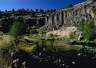
The Donner und Blitzen River is a river on the eastern Oregon high desert that drains a relatively arid basin, the southern portion of Harney Basin, from roughly 20 to 80 miles south-southeast of Burns including Malheur National Wildlife Refuge. Though much of its course is marsh, it offers scenic glaciated canyons, unique ecosystems, and exceptional wild trout fisheries. Named by soldiers of German origin, the Donner und Blitzen River translates as "thunder and lightning". The name usually brings to mind two of Santa Claus's reindeer, but the river is named for a thunderstorm the soldiers experienced as they crossed the river; dry lightning is an almost daily occurrence in the region during certain times of the year.

<span class="mw-page-title-main">Oregon Outback</span>

Oregon Outback is an unofficial term generally used to reference the high desert Basin and Range country of the central southern portion of the U.S. state of Oregon and covers most of Lake County, Klamath County, Malheur County, and Harney County.

<span class="mw-page-title-main">Oregon Route 205</span> Highway in Oregon

Oregon Route 205 (OR 205) is a state highway in Harney County, Oregon, running from Roaring Springs Ranch to OR 78 near Burns. OR 205 is known as the Frenchglen Highway No. 440 . It is 73.35 miles (118.05 km) long and runs north–south, connecting the Malheur National Wildlife Refuge to Burns. The highway has also been designated the High Desert Discovery Scenic Byway by the Bureau of Land Management. Part of OR 205 also is used in the Steens Mountain Back Country Byway, a loop road around Steens Mountain.

<span class="mw-page-title-main">Plush, Oregon</span> Unincorporated community in the state of Oregon, United States

Plush is an unincorporated rural community and census-designated place in the Warner Valley of Lake County, in the U.S. state of Oregon. As of the 2010 census it had a population of 57. The community is in an arid, sparsely populated part of the state 39 miles (63 km) by road northeast of Lakeview. The valley surrounding Plush contains many marshes and shallow lakes, most of them intermittent.

<span class="mw-page-title-main">Harney Lake</span> Alkali lake basin in Oregon, US

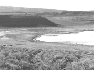
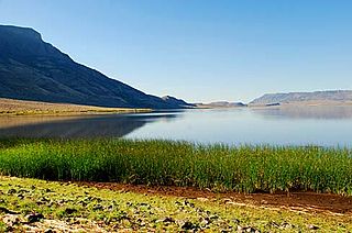
Harney Lake is a shallow alkali lake basin located in southeast Oregon, United States, approximately 30 miles (48 km) south of the city of Burns. The lake lies within the boundary of the Malheur National Wildlife Refuge and is the lowest point in the Blitzen Valley drainage.

<span class="mw-page-title-main">High Desert (Oregon)</span> A region of the U.S. state of Oregon

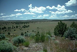
The Oregon High Desert is a region of the U.S. state of Oregon located east of the Cascade Range and south of the Blue Mountains, in the central and eastern parts of the state. Divided into a southern region and a northern region, the desert covers most of five Oregon counties and averages 4,000 feet (1,200 m) above sea level. The southwest region is part of the Great Basin and the southeast is the lower Owyhee River watershed. The northern region is part of the Columbia Plateau, where higher levels of rainfall allow the largest industry on private land to be the cultivation of alfalfa and hay. Public land within the region is owned primarily by the Bureau of Land Management, which manages more than 30,000 square miles (78,000 km2) including five rivers designated as Wild and Scenic.

<span class="mw-page-title-main">Diamond, Oregon</span> Unincorporated community in the state of Oregon, United States

Diamond is an unincorporated community in Harney County, Oregon, United States. Diamond is west of Oregon Route 205 and south of Malheur Lake, 52 miles (84 km) south-southeast of Burns by highway. Its post office is assigned ZIP code 97722.

<span class="mw-page-title-main">Stone Bridge and the Oregon Central Military Wagon Road</span> United States historic place

The Stone Bridge is a causeway built by the United States Army in 1867. It crosses the marshy channel that connects Hart Lake and Crump Lake in a remote area of Lake County in eastern Oregon, United States. It was later incorporated into the Oregon Central Military Wagon Road which was completed in 1872. The wagon road eventually became the subject of scandal and litigation ending with a United States Supreme Court decision in 1893. The Stone Bridge and the Oregon Central Military Wagon Road were listed together on the National Register of Historic Places in 1974. Today, the Stone Bridge is located on land claimed by the State of Oregon under riparian rights. The wagon road adjacent to the Stone Bridge is owned by the United States Government and is administered by Bureau of Land Management.

<span class="mw-page-title-main">Warner Valley</span> Valley in south-central Oregon

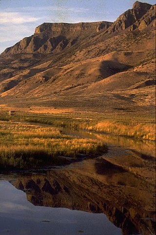
The Warner Valley is a valley in south-central Oregon in the United States. It is a remote valley at the northwestern corner of North America's Basin and Range Province. The valley is home to a chain of lakes and wetlands known as the Warner Lakes. Native Americans were present in the Warner Valley for thousands of years before European explorers arrived in the 19th century. It is the site of Fort Warner, built by the United States Army in 1867. The fort was used as a supply depot and administrative headquarters during a protracted Army campaign against Northern Paiute bands in eastern Oregon and northern California. Today, livestock ranching is the main commercial activity in the valley. The Warner Valley offers a number of recreational opportunities including hunting, fishing, bird watching, and wildlife viewing.

<span class="mw-page-title-main">Hart Lake (Oregon)</span> Lake of the United States of America

Hart Lake is a shallow lake in the Warner Valley of eastern Lake County, Oregon, United States. The lake covers 7,324 acres (29.64 km2) and has the most stable water level within the valley's Warner Lakes chain. The lake is named for the heart-shaped brand used by the pioneer Wilson and Alexander cattle ranch established near the lake. Much of the land around Hart Lake is administered by the Bureau of Land Management (BLM) and the United States Fish and Wildlife Service (FWS). The lake and the surrounding wetlands support a wide variety of birds and other wildlife. Recreational opportunities on and near Hart Lake include hunting, fishing, bird watching, and boating.

<span class="mw-page-title-main">P Ranch</span> United States historic place

The P Ranch is a historic ranch in Harney County in southeastern Oregon, United States. The remaining ranch structures are located on the west bank of the Donner und Blitzen River in the Malheur National Wildlife Refuge. The ranch was built by Peter French, a well known 19th-century cattle baron. The P Ranch became headquarters for the French-Glenn Livestock Company, which eventually covered over 140,000 acres (570 km2). After French was murdered in 1897, the French-Glenn Livestock Company slowly sold off the P Ranch property. In 1935, the United States Government purchased the remaining P Ranch property to add to an adjacent wildlife refuge. The Civilian Conservation Corps demolished most of the original ranch buildings in the 1930s, and a fire destroyed the main ranch house in 1947. The few remaining P Ranch structures are now listed on the National Register of Historic Places.

<span class="mw-page-title-main">Sod House Ranch</span> United States historic place

The Sod House Ranch is a historic ranch in Harney County in southeastern Oregon, United States. The remaining ranch structures are located south of Malheur Lake in the Malheur National Wildlife Refuge. The ranch was built by Peter French, a well known 19th-century cattle baron. The Sod House Ranch became the headquarters for the northern operating division of the French-Glenn Livestock Company, which eventually covered over 140,000 acres (570 km2). After French was murdered in 1897, the French-Glenn Livestock Company slowly sold off its ranch property. In 1935, the United States Government purchased the Sod House Ranch property to add to an adjacent wildlife refuge. The eight remaining Sod House Ranch buildings are now listed on the National Register of Historic Places.

Rock Creek is a 56-mile (90 km) intermittent stream flowing in Lake and Harney counties in the U.S. state of Oregon. The source of Rock Creek is at an elevation of 6,914 feet (2,107 m) on Hart Mountain, while the mouth is at an elevation of 4,557 feet (1,389 m) in the Catlow Valley. Rock Creek has a 269-square-mile (700 km2) watershed.

<span class="mw-page-title-main">Bill Hanley (rancher)</span>

William D. Hanley was a pioneer rancher in Harney County in southeastern Oregon. He owned several ranches between Burns, Oregon and Harney Lake. Together, his properties comprised one of the largest privately owned cattle operations in the United States. Hanley was also a progressive thinker and well known host. Among his personal friends were leading political figures, fellow cattle barons, industrialist, writers, and artists including Theodore Roosevelt, William Howard Taft, William Jennings Bryan, Peter French, James J. Hill, CES Wood, and Will Rogers. Hanley's progressive political views led him to run for Governor of Oregon and the United States Senate. A strong advocate of wildlife conservation, much of his ranch is now part of the Malheur National Wildlife Refuge.

<span class="mw-page-title-main">Double-O Ranch Historic District</span> Historic district in Oregon, United States

The Double-O Ranch Historic District is located west of Harney Lake in Harney County in southeastern Oregon, United States. At one time, the Double-O Ranch covered over 17,000 acres (69 km2). The ranch was owned by Bill Hanley, a well-known cattle baron and Bull Moose progressive. In 1941, the United States Government purchased most of the Double O Ranch property and added it to the Malheur National Wildlife Refuge. The two remaining Double-O Ranch buildings are now listed on the National Register of Historic Places.

<span class="mw-page-title-main">David L. Shirk Ranch</span> United States historic place

The David L. Shirk Ranch is a historic ranch located in the Guano Valley of eastern Lake County, Oregon, United States. The ranch was originally homesteaded in 1881. It was purchased by David L. Shirk in 1883. He operated the ranch until 1914. The property was acquired by the United States Government in 1942. The ranch is now administered by the Bureau of Land Management. The remaining historic ranch buildings are listed on the National Register of Historic Places.

<span class="mw-page-title-main">Whitehorse Ranch</span> Cattle Ranch in Oregon, United States

The Whitehorse Ranch is a historic cattle ranch in Harney and Malheur counties in the southeastern corner of Oregon, United States. The ranch was started in 1869 by John S. Devine, a well-known 19th-century cattle baron. It was originally the headquarters for the Todhunter and Devine Cattle Company. The ranch has been in the cattle business continuously since it was founded. Today, the Whitehorse Ranch includes 63,222 acres (255.85 km2) of deeded property and grazing rights on an additional 287,205 acres (1,162.28 km2) of public range land administered by the Bureau of Land Management.

<span class="mw-page-title-main">High Desert Discovery Scenic Byway</span>

The High Desert Discovery Scenic Byway is a 127-mile-long (204 km) scenic highway in the southeastern part of the U.S. state of Oregon. It runs through the state's high desert country from the town of Burns to the unincorporated community of Fields. It was designated as an Oregon Scenic Byway in 2003. The highway is maintained by the Oregon Department of Transportation (ODOT). There are a number of points of interest along the route including several that are listed on the National Register of Historic Places.

<span class="mw-page-title-main">Crump Lake (Oregon)</span> Natural lake in Oregon, US

Crump Lake is a shallow lake in the Warner Valley of eastern Lake County, Oregon, United States. The lake covers 7,680 acres (31.1 km2). It is the largest of the Warner Lakes system. The lake is named for pioneer rancher Thomas Crump. Crump Lake is owned by the Oregon Department of State Lands. Much of the land around the lake is administered by the Bureau of Land Management and the United States Fish and Wildlife Service. The lake and the surrounding wetlands support a wide variety of birds and other wildlife. Recreational opportunities on or near Crump Lake include fishing, bird watching, and camping.

References

  1. 1 2 "Catlow Valley". Geographic Names Information System . United States Geological Survey, United States Department of the Interior. 28 November 1980. Retrieved 8 September 2014.
  2. 1 2 3 4 5 6 7 8 9 10 11 12 13 LaLande, Jeff, "Catlow Valley", The Oregon Encyclopedia, Portland State University, Portland, Oregon, 2008.
  3. 1 2 3 4 "Catlow Valley", Oregon topographic map, United States Geological Survey, United States Department of Interior, Reston, Virginia; displayed via ACME mapper, www.acme.com, 12 April 2014.
  4. McArthur, Lewis A. and Lewis L. McArthur, "Hart Mountain", Oregon Geographic Names (Seventh Edition), Oregon Historical Society Press, Portland, Oregon, 2003, p. 449.
  5. 1 2 Jackman, E.R. and R.A. Long, The Oregon Desert, Canton Press, Caldwell, Idaho: 1964, p. 368.
  6. Fuller, Richard E., "Southern Steens and its Relation to Pueblo Mountain" Archived 26 January 2007 at the Wayback Machine , The Geomorphology and Volcanic Sequence of Steens Mountain in Southeastern Oregon (Volume 3, Number 1), University of Washington Press, Seattle, Washington, November 1931.
  7. 1 2 Forrester, J.W., "Cattle/Harney Made to Order", The Bulletin, Bend, Oregon, 15 October 1991, p. A-4.
  8. 1 2 3 4 5 "Beatys Butte Herd Management Area" Archived 19 April 2014 at the Wayback Machine (PDF), Lakeview District, Bureau of Land Management, United States Department of Interior, Lakeview, Oregon, 2 April 2014.
  9. 1 2 3 4 Oregon Wilderness Environmental Impact Statement (Volume III), Bureau of Land Management, United States Department of Interior, Portland, Oregon, 1985, pp. 236–237.
  10. 1 2 "Catlow Cave", Oregon State Office, Bureau of Land Management, United States Department of Interior, Portland, Oregon, 23 March 2014.
  11. 1 2 Cressman, L. S., "Oregon's Ancient Civilization…How Old?", The Northwest's Own Magazine, The Sunday Oregonian, Portland, Oregon, 12 April 1936, p. 5.
  12. 1 2 "Normals Monthly Station Details", P Ranch Refuge Reporting Station (GHCND:USC00356853), National Climatic Data Center, National Oceanic and Atmospheric Administration, Department of Commerce, Asheville, North Carolina, 13 April 2014.
  13. Oregon Wilderness Environmental Impact Statement (Volume III), Bureau of Land Management, United States Department of Interior, Portland, Oregon, 1985, pp. 367368.
  14. Jackman, E. R. and John Scharff, Steens Mountain in Oregon's High Desert Country, Caxton Printers, Caldwell, Idaho, 1967, p. 36.
  15. 1 2 3 4 Rakestraw, John, "Southern Harney County", in Birding Oregon, Morris Book Publishing, Kearney, Nebraska, 2007, pp. 1722.
  16. 1 2 3 Oregon Wilderness Environmental Impact Statement (Volume III), Bureau of Land Management, United States Department of Interior, Portland, Oregon, 1985, p. 282.
  17. "Mammal Checklists of the United States - Hart Mountain National Antelope Refuge" Archived 22 October 2013 at the Wayback Machine , Northern Prairie Wildlife Research Center, United States Geological Survey, United States Department of the Interior, Jamestown, North Dakota, 1 February 2013.
  18. "Amphibian and Reptile Checklists of the United States - Hart Mountain National Antelope Refuge" Archived 22 October 2013 at the Wayback Machine , Northern Prairie Wildlife Research Center, United States Geological Survey, United States Department of the Interior, Jamestown, North Dakota, 1 February 2013.
  19. Oregon Wilderness Environmental Impact Statement (Volume III), Bureau of Land Management, United States Department of Interior, Portland, Oregon, 1985, p. 239.
  20. "Catlow Valley Redband Trout" (PDF), Oregon Native Fish Status Report (Volume II), Oregon Department of Fish and Wildlife, Salem, Oregon, 2005, p. 379.
  21. "Fish Checklists of the United States - Hart Mountain National Antelope Refuge" Archived 22 October 2013 at the Wayback Machine , Northern Prairie Wildlife Research Center, United States Geological Survey, United States Department of the Interior, Jamestown, North Dakota, 1 February 2013.
  22. O'Grady, Patrick and Scott Thomas, "Archaeology in Harney County" Archived 20 October 2013 at the Wayback Machine (PDF), Destination Harney County 2010, Burns Times-Herald, Burns, Oregon, 31 March 2010, p. 36.
  23. Cressman, Luther S., "Prehistory of the Northern Area", Handbook of North American Indians: Great Basin, Government Printing Office, Washington, District of Columbia, 1986, p. 120.
  24. Mehringer, Peter, "A Tale of Two Sites" Archived 19 April 2014 at the Wayback Machine (PDF), Anthro News, Department of Anthropology, Washington State University, Pullman, Washington, Spring 1997, pp. 1–2.
  25. Carey, Charles H., General History of Oregon, (originally published by the Pioneer Historical Publishing Company, 1922) re-issued by Binford and Mort, Portland, Oregon, 1971, p. 228.
  26. McArthur, Lewis A. and Lewis L. McArthur, "Beatys Butte", Oregon Geographic Names (Seventh Edition), Oregon Historical Society Press, Portland, Oregon, 2003, p. 64.
  27. McArthur, Lewis A. and Lewis L. McArthur, "Camp Warner", Oregon Geographic Names (Seventh Edition), Oregon Historical Society Press, Portland, Oregon, 2003, p. 152.
  28. Bach, Melva M., "Camp Warner Moved to Honey Creek – 1867" (PDF), History of the Fremont National Forest, Fremont National Forest, United States Forest Service, United States Department of Agriculture, Lakeview, Oregon, 1981, p. 14.
  29. Hutchings, Terri Crockett, "Pvt Lewis Debold", non-cemetery burial, www.findagrave.com, Provo, Utah, 13 March 2010.
  30. "Oregon Central Military Road" Archived 21 January 2009 at the Wayback Machine , Oregon State Office, Bureau of Land Management, United States Department of Interior, Portland, Oregon, 17 September 2009.
  31. "Oregon History: Uncle Sam's Handiwork", Oregon Blue Book, Oregon State Archives, Office of the Secretary of State, State of Oregon, Salem, Oregon, 17 September 2009.
  32. 1 2 McArthur, Lewis A. and Lewis L. McArthur, "Catlow", Oregon Geographic Names (Seventh Edition), Oregon Historical Society Press, Portland, Oregon, 2003, p. 180.
  33. "A Little Bit of Malheur History" Archived 27 September 2014 at the Wayback Machine , Malheur National Wildlife Refuge, United States Fish and Wildlife Service, United States Department of Interior, Princeton, Oregon, 10 November 2008.
  34. 1 2 Conkling, Charles, E. R. Jackman, and John Scharff, "Catlow Valley", Steens Mountain in the Oregon's High Desert Country, Caxton Printers, Caldwell, Idaho, 1979, pp. 174176.
  35. "Shirk Ranch" (PDF), Cultural Resource Inventory: Sheldon National Wildlife Refuge and Hart Mountain National Wildlife Refuge, United States Fish and Wildlife Service, United States Department of Interior, Portland, Oregon, February 1985, pp. 57–70.
  36. "Harriman on Map", The Oregonian, Portland, Oregon, 13 August 1907, p. 8.
  37. Embree, T.V.B., "Harney, Land of Promise", The Oregonian, Portland, Oregon, 27 July 1908, p. 12.
  38. 1 2 Maxwell, Ben, "Rough Road Through Catlow Valley Recalls Hard-Scrabble Existence of Early, Settlers", The Oregonian, Portland, Oregon, 14 October 1963, p. 6.
  39. McArthur, Lewis A. and Lewis L. McArthur, "Beckley", Oregon Geographic Names (Seventh Edition), Oregon Historical Society Press, Portland, Oregon, 2003, p. 67.
  40. McArthur, Lewis A. and Lewis L. McArthur, "Delaine", Oregon Geographic Names (Seventh Edition), Oregon Historical Society Press, Portland, Oregon, 2003, pp. 275–276.
  41. McArthur, Lewis A. and Lewis L. McArthur, "Berdugo", Oregon Geographic Names (Seventh Edition), Oregon Historical Society Press, Portland, Oregon, 2003, p. 74.
  42. McArthur, Lewis A. and Lewis L. McArthur, "Sageview", Oregon Geographic Names (Seventh Edition), Oregon Historical Society Press, Portland, Oregon, 2003, p. 836.
  43. McArthur, Lewis A. and Lewis L. McArthur, "Tiara", Oregon Geographic Names (Seventh Edition), Oregon Historical Society Press, Portland, Oregon, 2003, p. 953.
  44. McArthur, Lewis A. and Lewis L. McArthur, "Blitzen", Oregon Geographic Names (Seventh Edition), Oregon Historical Society Press, Portland, Oregon, 2003, p. 90.
  45. Saunders, Lucile F., "Retreat of Oregon Antelope Land of Lava Rock, Sage, Dust Whirlpools and Peculiar Houses", Section 4, The Sunday Oregonian, Portland, Oregon, 21 September 1924, p. 10.
  46. Maxwell, Ben, "Where Jackrabbits have Roads", The Sunday Oregonian, Portland, Oregon, 9 September 1928, p. 6.
  47. 1 2 "Blitzen", Burns Times-Herald, Burns, Oregon, 20 May 1987.
  48. 1 2 Conkling, Charles, E. R. Jackman, and John Scharff, "The Mashlands", Steens Mountain in the Oregon's High Desert Country, Caxton Printers, Caldwell, Idaho, 1979, pp. 42–43.
  49. Cockle, Richard, "Federal Bureaucrat, Oregon Cowboy Swap Jobs as Learning Experience",The Oregonian, Portland, Oregon, 27 July 2008.
  50. "Environmental Stewardship Award Past Winners" Archived 19 April 2014 at the Wayback Machine (PDF), National Cattlemen's Beef Association, Centennial, Colorado, 13 April 2014.
  51. 1 2 3 "High Desert Discovery Scenic Byway" Archived 26 February 2013 at the Wayback Machine (PDF), Oregon State Scenic Byways, Oregon Department of Transportation, Salem, Oregon, 13 April 2014.