Chancellor, South Dakota | |
---|---|
Coordinates: 43°22′21″N96°59′16″W / 43.37250°N 96.98778°W | |
Country | United States |
State | South Dakota |
County | Turner |
Founded | 1895 [1] |
Government | |
• Board of Trustees | Varies |
Area | |
• Total | 0.22 sq mi (0.57 km2) |
• Land | 0.22 sq mi (0.57 km2) |
• Water | 0.00 sq mi (0.00 km2) |
Elevation | 1,362 ft (415 m) |
Population | |
• Total | 300 |
• Density | 1,363.64/sq mi (527.57/km2) |
Time zone | UTC-6 (Central (CST)) |
• Summer (DST) | UTC-5 (CDT) |
ZIP code | 57015 |
Area code | 605 |
FIPS code | 46-11380 [5] |
GNIS feature ID | 1267326 [3] |
Chancellor is a town in Turner County, South Dakota, United States. The population was 300 at the 2020 census. [6]
The community was named for Otto von Bismarck, Chancellor of the German Empire. [7]
According to the United States Census Bureau, the town has a total area of 0.22 square miles (0.57 km2), all land. [8]
Security Bank, Denning Companies, Total Stop, Hostetler Repair, Prime Risk Management, Chancellor Bar, Chancellor Event Center
Census | Pop. | Note | %± |
---|---|---|---|
1910 | 160 | — | |
1920 | 280 | 75.0% | |
1930 | 207 | −26.1% | |
1940 | 232 | 12.1% | |
1950 | 193 | −16.8% | |
1960 | 214 | 10.9% | |
1970 | 220 | 2.8% | |
1980 | 257 | 16.8% | |
1990 | 276 | 7.4% | |
2000 | 328 | 18.8% | |
2010 | 264 | −19.5% | |
2020 | 300 | 13.6% | |
U.S. Decennial Census [9] [4] |
As of the census [10] of 2010, there were 264 people, 118 households, and 75 families residing in the town. The population density was 1,200.0 inhabitants per square mile (463.3/km2). There were 131 housing units at an average density of 595.5 per square mile (229.9/km2). The racial makeup of the town was 97.3% White, 0.4% African American, 0.4% Native American, 0.4% Asian, and 1.5% from two or more races. Hispanic or Latino of any race were 0.8% of the population.
There were 118 households, of which 28.8% had children under the age of 18 living with them, 53.4% were married couples living together, 7.6% had a female householder with no husband present, 2.5% had a male householder with no wife present, and 36.4% were non-families. 33.9% of all households were made up of individuals, and 11.9% had someone living alone who was 65 years of age or older. The average household size was 2.24 and the average family size was 2.80.
The median age in the town was 39.9 years. 22.3% of residents were under the age of 18; 9.9% were between the ages of 18 and 24; 24.3% were from 25 to 44; 25% were from 45 to 64; and 18.6% were 65 years of age or older. The gender makeup of the town was 49.6% male and 50.4% female.
As of the census [5] of 2000, there were 328 people, 134 households, and 88 families residing in the town. The population density was 1,328.8 inhabitants per square mile (513.1/km2). There were 142 housing units at an average density of 575.3 per square mile (222.1/km2). The racial makeup of the town was 97.87% White, 0.91% Native American, and 1.22% from two or more races. Hispanic or Latino of any race were 0.30% of the population.
There were 134 households, out of which 35.1% had children under the age of 18 living with them, 56.0% were married couples living together, 8.2% had a female householder with no husband present, and 33.6% were non-families. 32.1% of all households were made up of individuals, and 15.7% had someone living alone who was 65 years of age or older. The average household size was 2.45 and the average family size was 3.07.
In the town, the population was spread out, with 26.8% under the age of 18, 9.1% from 18 to 24, 28.7% from 25 to 44, 18.0% from 45 to 64, and 17.4% who were 65 years of age or older. The median age was 32 years. For every 100 females, there were 90.7 males. For every 100 females age 18 and over, there were 92.0 males.
The median income for a household in the town was $30,500, and the median income for a family was $42,250. Males had a median income of $22,750 versus $19,167 for females. The per capita income for the town was $18,156. None of the families and 4.2% of the population were living below the poverty line, including no under eighteens and 11.8% of those over 64.
Chancellor is a part of the Lennox School District 41-4, [11] which operates LWC Junior High School/Lennox High School in Lennox. [12]
Yale is an incorporated town in Beadle County, South Dakota, United States. The population was 112 at the 2020 census.
Tabor is a town in Bon Homme County, South Dakota, United States. The population was 407 at the 2020 census.
Westport is a town in western Brown County, South Dakota, United States. The population was 88 at the 2020 census.
Ravinia is a town in Charles Mix County, South Dakota, United States. The population was 71 at the 2020 census.
Ethan is a town in Davison County, South Dakota, United States. It is part of the Mitchell, South Dakota Micropolitan Statistical Area. The population was 365 at the 2020 census. Ethan is located 10 miles south of Mitchell.
Clear Lake is a city in and the county seat of Deuel County, South Dakota, United States. The population was 1,218 at the 2020 census.
Onaka is a town in Faulk County, South Dakota, United States. The population was 13 at the 2020 census.
Revillo is a town in southeastern Grant County, South Dakota, United States. The population was 99 at the 2020 census.
Kadoka is a city in, and the county seat of, Jackson County, South Dakota, United States. The population was 543 at the 2020 census. The town occupies about 2.3 square miles.
Fairview is a town in Lincoln County, South Dakota, United States. The population was 61 at the 2020 census.
Lennox is a city in Lincoln County, South Dakota, United States, located 20 miles (32 km) southwest of Sioux Falls. The population was 2,423 at the 2020 census.
Worthing is a city in Lincoln County, South Dakota, United States and is a suburb of Sioux Falls. The population was 927 at the 2020 census.
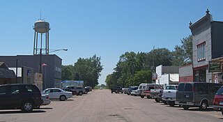
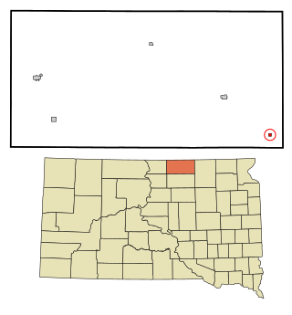
Crooks is a city in Minnehaha County, South Dakota, United States and is a suburb of Sioux Falls. The population was 1,362 at the 2020 census. Crooks was named New Hope until 1904. The town's present name honors W. A. Crooks, a local politician.
Sherman is a town in Minnehaha County, South Dakota, United States. The population was 81 at the 2020 census.
Corona is a town in Roberts County, South Dakota, United States. The population was 69 at the 2020 census.
Rosholt is a town in Roberts County, South Dakota, United States. The population was 379 at the 2020 census.
Tulare is a town in Spink County, South Dakota, United States. The population was 211 at the 2020 census.
New Witten is a town in Tripp County, South Dakota, United States. The population was 54 at the 2020 census.
Lowry is a town in Walworth County, South Dakota, United States. The population was 10 at the 2020 census. The town is home to Lowry Pilgrim Community Church, Swan Creek Harness Shop, J & C Repair, Karst Service and a fire station. Lowry also has an abandoned school, and a post office, which closed to service in the early 1970s.
Lesterville is a town in Yankton County, South Dakota, United States. The population was 115 at the 2020 census.