Chemmappilly

Last updated

Chemmappilly is a place in Thrissur District, Kerala, 23 km from Thrissur. It is in the jurisdiction of Anthikad Police station and the Grama Panchayath is Thanniyam. There is a lower primary school called ALPSchool in the centre. Nearest places are Thriprayar, Nattika, and Peringottukara. This place is on the bank of the river Theevra (Canoli Canal). The postal area is Vadakkummuri-680570. The only Government office is the post office.

Anthikad village in Kerala, India

Anthikad is a village in Thrissur district in the state of Kerala, India. It is in Thrissur Thaluk, Nattika constituency and Anthikad Block. Manalur and Thanyam are the nearest panjayaths. Anthikad is famous for toddy production and paddy fields. Anthikad won `Nelkathir' award for best paddy cultivation in kelara in 2008. Anthikad is the headquarter for the Major Financial enterprise, Peringottukara Namboothiri Yogashkema Sabha Credit & Investment Company Ltd. which is formed in the year 1907.Headquarters of India's biggest gold loan company Manapuram finance limited is also located here.

Thanniyam village in Kerala, India

Thanniyam is a village in Thrissur district in the state of Kerala, India.

Nattika Village in Kerala, India

Nattika is a small village in Thrissur district of Kerala state, South India. It is centrally located about 25 km from Thrissur, Kodungallur, Irinjalakuda, Chavakkad, Kunnamkulam and Guruvayur. Nattika is beside the Arabian Sea. There is a beach in this village called Nattika Beach. Nattika Beach was previously known as Attakuzhi Bandhar Kadapuram. Nattika is on the west coast of Thrissur. Conolly Canal is the eastern border of Nattika. There is a private bus stand in Thriprayar. Nattika is 60 km away from Cochin International Airport and 25 km away from Thrissur Railway Station. Modern transportation and better communication facilities are available in the village. This is an assembly constituency.

Contents

In former days at Sreeraman Chira, the sethubandhanam was done by Sambava community. At that time human sacrifice was observed. The last person killed in Sreeraman chira was Chennan. from the name of Chennan this place got the name "Chennan kol" ("kol" means "paddy field"[ clarification needed ]). Finally "Chennan kol" [1] became Chemmappilly.

Sreeraman Chira

Sreeraman Chira is a fresh water lake which contains 900 hectares of paddy fields situated in Chemmappilly near Triprayar of Thrissur district of Kerala state in India. The lake is linked to Ramayana fame, where Chira kettal ceremony reminiscent of the Sethubandhanam where Hanuman and his army built Rama Setu to reach Sri Lanka and rescue Sita from the Rakshasa King, Ravana.

The name Rama's Bridge or Rama Setu refers to the bridge built by the Vanara army of Lord Rama in Ramayana, with instructions from Nala, which he used to reach Lanka and rescue Sita from the Rakshasa king, Ravana. The Ramayana attributes the building of this bridge to Rama in verse 2-22-76, naming it as Setubandhanam, a name that persists until today.

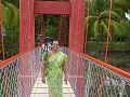
A hanging bridge was constructed to connect Thannyam and Nattika Grama Panchayaths. It was inaugurated by Shri Adoor Prakash on 31 May 2013. Phoenix Library is working at Chemmappilly. The road to Chemmappily touches Peringottukara and Thriprayar East Nada. Aneswaram Shiva temple and a Mosque are here. During the "Grama pradakshinam" of Thriprayar Thevar at the time of Arattupuzha Devamela, Thevan ran away from Aneswaram Siva, without any sound because Thevar borrowed paddy and coconut from Lord Aneswaram Siva.[ clarification needed ]

See also

Sethubandhanam at Sreeraman Chira or Chira kettal is a Hindu ceremony reminiscent of the Sethubandhanam where Hanuman and his army built Rama Setu to reach Sri Lanka and rescue Sita from the Rakshasa King, Ravana. It is annually conducted at Sreeraman Chira, a 900 hectares of paddy fields situated in Chemmappilly near Triprayar of Thrissur district of Kerala state in India.

Nalambalam is a set of four Hindu temples in Kerala. In Malayalam, Nalu means "four" and Ambalam means "temple". These are the temples for the Rama and his brothers of Ramayana.

Images

Related Research Articles

Cherpu town in Kerala, India

Cherpu is a small village in Thrissur district of Kerala state in south India. It is 12 kilometres south of Thrissur town and is on the Thriprayar road. It is dotted by a number of temples and has quite a few rivers flowing by its vicinity.

Thrissur district District in Kerala, India

Thrissur is a revenue district of Kerala situated in the central part of that state. Spanning an area of about 3,032 km2, Thrissur district is home to over 10% of Kerala’s population.

Thriprayar Temple temple in India

Thriprayar Shree Ramaswami Temple is Hindu temple situated in Triprayar in Thrissur district of Kerala state in India. The deity is Lord Rama, the seventh incarnation of Lord Vishnu, with four arms bearing a conch, a disc, a bow and a garland. The temple is situated on the bank of river Theevra. The temple deity is the presiding deity of Arattupuzha Pooram. It is believed that the idol here was worshipped by Lord Krishna, another avatar of Lord Vishnu in Dwarka. Along with Lord Rama, there are shrines for Lord Shiva as Dakshinamoorthy, Lord Ganesha, Lord Sastha and Lord Krishna.

Peralasseri city in Kerala, India

Peralasseri is a census town in Kannur district in the Indian state of Kerala, situated on the Kannur-Kuthuparamba high road 12 km from Kannur town, on the bank of Anjarakandy river.

Triprayar Town in Kerala, India

Thriprayar is a town in Thrissur District of Kerala, India. It is famous for the Thriprayar Temple.it is suburban town of the thrissur city.

Ammathiruvadi Temple

The magnificent ancient Devi temple is situated in Urakam, a serene village, located approximately about 12 km from Thrissur city and almost the same distance from Irinjalakuda town when one travel towards Thrissur.

Ezhumanthuruthu (എഴുമാന്തുരുത്ത്) is a small "thuruthu" i.e. island situated 8 km west of Kaduthuruthy town. It falls in Kottayam district, the city of letters. It is a densely populated place of Kaduthuruthy Gram Panchayat.

Chelakkara Town in Kerala, India

Chelakkara is a small town in Thrissur district of Kerala.

Vylathur village in Kerala, India

Vylathur is a village in Thrissur district in Kerala state in south India, close to Guruvayoor. The commercial town of Kunnamkulam is also a few minutes drive. The post office which serves the place is Nhamanghat.

Ayyappancoil village in Kerala, India

Ayyappancoil, also spelt Ayyappankovil is a village in newly formed Idukki taluk in Idukki district in the Indian state of Kerala. It is highly noted for the newly constructed suspension bridge and the old historic Sastha temple on the banks of Periyar river.

Chazhoor village in Kerala, India

Chazhoor (Chazhur) is a village in Thrissur Taluk of Thrissur district in the state of Kerala, India. Thriprayar (4 km), Thrissur (22 km), and Chavakkad (17 km) are nearby cities. Chazhoor is 4 km away from Snehatheeram beach.

Thuravoor, Angamaly village in Kerala, India

Thuravoor is a Grama Panchayath in Aluva Taluk of Ernakulam District in the South Indian state of Kerala. Thuravoor Grama Panchayath is nearly 5 km from Angamaly Town. The Panchayat covers 12.13 km2 in area. The borders of this panchayat are Mookkannoor and Manjapra Panchayat in the north, Manjapra, Malayattoor-Neeleeswaram Panchayat in the East. Kalady panchayat and Angamaly Municipality in the south, and Karukutty and Mookkannoor Panchayat on the west.

Kallambalam is a town in Thiruvananthapuram district, Kerala. Kallambalam joints Varkala with National Highway 66. It is 41 km north from Thiruvananthapuram, 30 km south of Kollam city, 13 km West of Kilimanoor and 10 km East of Varkala

Kattoor, Thrissur Town in Kerala, India

Kattoor is a small village in Irinjalakuda Block of Thrissur district, Kerala, India.

Aneswaram Siva temple is at Chemmappilly, the western area of Thrissur District. Its main Deity is Shiva. This was owned by a Namboothiri illam. Now it is one of the several temples governed by the Cochin Devaswom Board, an autonomous body constructed by Government of Kerala to manage the temples.Every year Vavu bali is conducted here

References

  1. ഇ.പി.ഗിരീഷ്‌ (December 2013). "വന്ദനം സേതുബന്ധനം". ക്ഷേത്രദർശനം മാസിക Page 33 (A Cochin Devaswam Board Publication) (പത്രലേഖനം) (in Malayalam).

Coordinates: 10°25′34″N76°06′58″E / 10.426°N 76.116°E / 10.426; 76.116

Geographic coordinate system Coordinate system

A geographic coordinate system is a coordinate system that enables every location on Earth to be specified by a set of numbers, letters or symbols. The coordinates are often chosen such that one of the numbers represents a vertical position and two or three of the numbers represent a horizontal position; alternatively, a geographic position may be expressed in a combined three-dimensional Cartesian vector. A common choice of coordinates is latitude, longitude and elevation. To specify a location on a plane requires a map projection.