
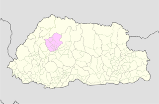
Wangdue Phodrang District is a Thromde and dzongkhag (district) of central Bhutan. This is also the name of the dzong which dominates the district. The name is said to have been given by the Shabdrung Ngawang Namgyal who was searching for the best location for a dzong to prevent incursions from the south. The word "wangdue" means unification of Country, and "Phodrang" means Palace in Dzongkha.

Trashigang District is Bhutan's easternmost dzongkhag (district).

Paro District is a district (dzongkhag), valley, river and town in Bhutan. It is one of the most historic valleys in Bhutan. Both trade goods and invading Tibetans came over the pass at the head of the valley, giving Paro the closest cultural connection with Tibet of any Bhutanese district. The dominant language in Paro is Dzongkha, the national language.

Chukha District is one of the 20 dzongkhag (districts) comprising Bhutan. The major town is Phuentsholing.

Lhuntse District is one of the 20 dzongkhag (districts) comprising Bhutan. It consists of 2506 households. Located in the northeast, Lhuentse is one of the least developed dzhongkhags of Bhutan. There are few roads, the first gas station was opened in September 2005, electricity is not well distributed, and the difficult terrain makes distribution of social welfare problematic. Despite its favorable climate, farming is hindered by the lack of infrastructure.

Mongar District is one of the 20 dzongkhags (districts) comprising Bhutan. Mongar is the fastest-developing dzongkhag in eastern Bhutan. A regional hospital has been constructed and the region is bustling with many economic activities. Mongar is noted for its lemon grass, a plant that can be used to produce an essential oil. It also has a hydroelectric power-plant on the Kuri Chhu river. Mongar is notable for having the longest work time in all the dzongkhags of Bhutan.

PemagatshelDistrict is one of the 20 Dzongkhags (districts) in Bhutan.
Punakha District is one of the 20 dzongkhags (districts) comprising Bhutan. It is bordered by Thimphu, Gasa, and Wangdue Phodrang Districts. The dominant language in the district is Dzongkha, the national language.

Samtse District is one of the 20 dzongkhags (districts) comprising Bhutan. It comprises two subdistricts (dungkhags): Tashicholing and Dophuchen. They are further subdivided into 15 gewogs. The Samtse district covers a total area of 1304 km2.

Trashiyangtse District is one of the twenty dzongkhags (districts) comprising Bhutan. It was created in 1992 when Trashiyangtse district was split off from Trashigang District. Trashiyangtse covers an area of 1,437.9 square kilometres (555.2 sq mi). At an elevation of 1750–1880 m, Trashi yangtse dzongkhag is rich of culture filled with sacred places blessed by Guru Rimpoche and dwelled by Yangtseps, Tshanglas, Bramis from Tawang, Khengpas from Zhemgang and Kurtoeps from Lhuentse.

Tsirang District is one of the 20 dzongkhags (districts) of Bhutan. The administrative center of the district is Damphu.
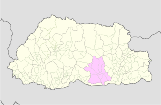
Zhemgang District, is one of the 20 dzongkhags (districts) comprising Bhutan. It is bordered by Sarpang, Trongsa, Bumthang, Mongar and Pemagatshel Districts, and borders Assam in India to the south. The administrative center of the district is Zhemgang.

A gewog, in the past also spelled as geog, is a group of villages in Bhutan. The head of a gewog is called a gup. Gewogs form a geographic administrative unit below dzongkhag districts, and above Dzongkhag Thromde class B and Yenlag Thromde municipalities. Dzongkhag Thromde class A municipalities have their own independent local government body.

Thimphu District is a dzongkhag (district) of Bhutan. Thimphu is also the capital of Bhutan and the largest city in the whole kingdom.
Phuentsholing Gewog is a gewog of Chukha District, Bhutan. The gewog has an area of 139.8 km2 and contains 19 villages and a population of 5,183, as of 2005. Phuentsholing Gewog is part of Phuentsholing Dungkhag, along with Dala, Logchina Gewogs and Shampheling Gewog. It is one of the most populated gewogs in Chukha Dzongkhag.
Nanong Gewog is a Gewog of Pemagatshel District, Bhutan.
Norbugang Gewog is a gewog of Pemagatshel District, Bhutan. Norbugang Gewog is part of Nganglam Dungkhag, along with Dechenling and Nganglam Gewogs.

Orong Gewog is a gewog of Samdrup Jongkhar District, Bhutan. It is situated north of Samdrup Jongkhar town. The Gewog is about 45 km from Samdrup Jongkhar with a 12 km Gewog Center (GC) road bifurcating from the national highway at Shekpashing which connects Samdrup Jongkhar and Trashigang District.
Lumang Gewog is a gewog of Trashigang District, Bhutan. Lumang and Khaling Gewogs comprise Wamrong Dungkhag (sub-district).
Thrimshing Gewog is a gewog of Trashigang District, Bhutan. Thrimshing Gewog, along with Kangpara Gewog, comprises Thrimshing Dungkhag (sub-district).
