
Wangdue Phodrang District is a Thromde and dzongkhag (district) of central Bhutan. This is also the name of the dzong which dominates the district. The name is said to have been given by the Shabdrung Ngawang Namgyal who was searching for the best location for a dzong to prevent incursions from the south. The word "wangdue" means unification of Country, and "Phodrang" means Palace in Dzongkha.

The Kingdom of Bhutan is divided into 20 districts. Bhutan is located between the Tibet Autonomous Region of China and India on the eastern slopes of the Himalayas in South Asia.

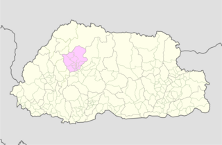
Gasa District or Gasa Dzongkhag is one of the 20 dzongkhags (districts) comprising Bhutan. The capital of Gasa District is Gasa Dzong near Gasa. It is located in the far north of the county and spans the Middle and High regions of the Tibetan Himalayas. The dominant language of the district is Dzongkha, which is the national language. Related languages, Layakha and Lunanakha, are spoken by semi-nomadic communities in the north of the district. The People's Republic of China claims the northern part of Gasa District.

PemagatshelDistrict is one of the 20 Dzongkhags (districts) in Bhutan.
Punakha District is one of the 20 dzongkhags (districts) comprising Bhutan. It is bordered by Thimphu, Gasa, and Wangdue Phodrang Districts. The dominant language in the district is Dzongkha, the national language.

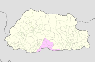
Tsirang District is one of the 20 dzongkhags (districts) of Bhutan. The administrative center of the district is Damphu.

A gewog, in the past also spelled as geog, is a group of villages in Bhutan. The head of a gewog is called a gup. Gewogs form a geographic administrative unit below dzongkhag districts, and above Dzongkhag Thromde class B and Yenlag Thromde municipalities. Dzongkhag Thromde class A municipalities have their own independent local government body.
A dungkhag is a sub-district of a dzongkhag (district) of Bhutan. The head of a dungkhag is a Dungpa. As of 2007, nine of the twenty dzongkhags had from one to three dungkhags, with sixteen dungkhags in total.

Punakha is the administrative centre of Punakha dzongkhag, one of the 20 districts of Bhutan. Punakha was the capital of Bhutan and the seat of government until 1955, when the capital was moved to Thimphu. It is about 72 km away from Thimphu, and it takes about 3 hours by car from the capital. Unlike Thimphu, it is quite warm in winter and hot in summer. It is located at an elevation of 1,200 metres above sea level, and rice is grown as the main crop along the river valleys of two main rivers of Bhutan, the Pho Chu and Mo Chu. Dzongkha is widely spoken in this district.
Metakha Gewog is a gewog of Chukha District, Bhutan. Metakha Gewog was established in 2016, and it is one of the smallest gewogs in Chukka Dzongkhag. The 100-km² gewog contains fifteen villages, 119 households and has a population of 1,036.
Sangbay or Sangbaykha Gewog is a gewog of Haa District, Bhutan. It is one of the western gewogs of the Haa district sharing borders with the Samtse District, India's Sikkim state and China's Chumbi Valley. The latter border has been contested by China, which claims the Doklam region as its territory. In recent years, China has begun to build villages in its claimed area.

Dopshari Gewog is a gewog of Paro District, Bhutan. In 2002, the gewog had an area of 36.7 square kilometres (14.2 sq mi) and contained 24 villages and 299 households.
Khatoed is a gewog of the Gasa dzongkhag (district) in Bhutan. It was formerly known as Goenkaatoe.
Sephu Gewog (Dzongkha: སྲས་ཕུག་, also transliterated as Saephoog Gewog is a gewog of Wangdue Phodrang District, Bhutan.
Umling Gewog is a gewog of Sarpang District, Bhutan.

Chali Gewog is a gewog of Mongar District, Bhutan. In 2002, the gewog contained 263 households and covered an area of 42 square kilometres.
Shumar Gewog is a gewog in Pemagatshel District, Bhutan.
The Local Government Act of Bhutan was enacted on September 11, 2009, by parliament of Bhutan in order to further implement its program of decentralization and devolution of power and authority. It is the most recent reform of the law on Bhutan's administrative divisions: Dzongkhags, Dungkhags, Gewogs, Chiwogs, and Thromdes (municipalities). The Local Government Act of Bhutan has been slightly amended in 2014.
A Thromde is a second-level administrative division in Bhutan. The legal administrative status of thromdes was most recently codified under the Local Government Act of 2009, and the role of thromdes in elections in Bhutan was defined in the Election Act of 2008.

Khamdang Gewog is a gewog of Trashiyangtse District, Bhutan.
