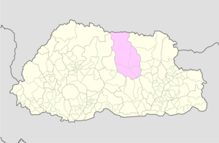
Kurtoed Gewog ཀུར་སྟོད་མཁོལ་མ་ | |
|---|---|
 | |
| Country | |
| District | Lhuntse District |
| Time zone | UTC+6 (BTT) |
Kurtoed Gewog (Dzongkha: ཀུར་སྟོད་) is a gewog (village block) of Lhuntse District, Bhutan. [1] [2] It is inhabited by speakers of the Kurtöp language.
Kurtoed Gewog ཀུར་སྟོད་མཁོལ་མ་ | |
|---|---|
| | |
| Country | |
| District | Lhuntse District |
| Time zone | UTC+6 (BTT) |
Kurtoed Gewog (Dzongkha: ཀུར་སྟོད་) is a gewog (village block) of Lhuntse District, Bhutan. [1] [2] It is inhabited by speakers of the Kurtöp language.

Wangdue Phodrang District is a dzongkhag (district) of central Bhutan. This is also the name of the dzong which dominates the district, and the name of the small market town outside the gates of the dzong—it is the capital of Wangdue Phodrang District). The name is said to have been given by the Shabdrung Ngawang Namgyal who was searching for the best location for a dzong to prevent incursions from the south. The word "wangdue" means unification of Country, and "Phodrang" means Palace in Dzongkha.

Trashigang District is Bhutan's easternmost dzongkhag (district).
Bumthang District is one of the 20 dzongkhag (districts) comprising Bhutan. It is the most historic dzongkhag if the number of ancient temples and sacred sites is counted. Bumthang consists of the four mountain valleys of Ura, Chumey, Tang and Choekhor ("Bumthang"), although occasionally the entire district is referred to as Bumthang Valley.

Chukha District is one of the 20 dzongkhag (districts) comprising Bhutan. The major town is Phuentsholing which is the gateway city along the sole road which connects India to western Bhutan. Chukha is the commercial and the financial capital of Bhutan. With Bhutan's oldest hydropower plant, Chukha hydel, and Tala Hydroelectricity Project, the country's largest power plant, Chukha is the dzongkhag which contributes the most to the GDP of the country. Also located in Chukha district are some of the country's oldest industrial companies like the Bhutan Carbide Chemical Limited (BCCL) and the Bhutan Boards Products Limited (BBPL).

Dagana District is a district located in Bhutan. Most of the district is populated by Dzongkha speakers. However, in the southwest part near the Sarpang District, Nepali is also spoken as a native language.

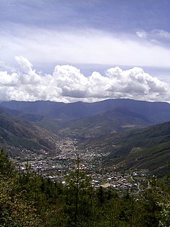
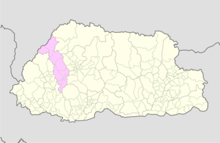
Lhuntse District is one of the 20 dzongkhag (districts) comprising Bhutan. It consists of 2506 households. Located in the northeast, Lhuntse is one of the least developed dzhongkhags of Bhutan. There are few roads, the first gas station was opened in September 2005, electricity is not well distributed, and the difficult terrain makes distribution of social welfare problematic. Despite its favourable climate, farming is hindered by the lack of infrastructure.

Pemagatshel District is one of the 20 dzongkhags (districts) constituting Bhutan.
Punakha District is one of the 20 dzongkhags (districts) comprising Bhutan. It is bordered by Thimphu, Gasa, and Wangdue Phodrang Districts. The dominant language in the district is Dzongkha, the national language.

Samtse District is one of the 20 dzongkhags (districts) comprising Bhutan.
Sarpang District is one of the 20 dzongkhags (districts) comprising Bhutan.

Trashiyangtse District is one of the twenty dzongkhags (districts) comprising Bhutan. It was created in 1992 when Trashiyangtse district was split off from Trashigang District. Trashiyangtse covers an area of 1,437.9 square kilometres (555.2 sq mi). At an elevation of 1750–1880 m, Trashi yangtse dzongkhag is rich of culture filled with sacred places blessed by Guru Rimpoche and dwelled by Yangtseps, Tshanglas, Bramis from Tawang, Khengpas from Zhemgang and Kurtoeps from Lhuentse.

Tsirang District (Dzongkha: རྩི་རང་རྫོང་ཁག་; Wylie: Rtsi-rang rdzong-khag; previously, is one of the 20 dzongkhags of Bhutan. The administrative center of the district is Damphu.
Zhemgang District, is one of the 20 dzongkhags (districts) comprising Bhutan. It is bordered by Sarpang, Trongsa, Bumthang, Mongar and Samdrup Jongkhar Districts, and borders Assam in India to the south. Administrative center of the district is Zhemgang.

A gewog, in the past also spelled as geog, refers to a group of villages in Bhutan. The head of a gewog is called a gup. Gewogs form a geographic administrative unit below dzongkhag districts, and above Dzongkhag Thromde class B and Yenlag Thromde municipalities. Dzongkhag Thromde class A municipalities have their own independent local government body.
Thimphu District is a dzongkhag (district) of Bhutan. Thimphu is also the capital of Bhutan and the largest city in the whole kingdom.

Trongsa District is one of the districts of Bhutan. It is the most central district of Bhutan and the geographic centre of Bhutan is located within it at Trongsa Dzong.
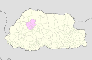
Lingzhi Gewog is a gewog of Thimphu District, Bhutan. Lingzhi Gewog, along with Naro and Soe Gewogs, is part of Lingzhi Dungkhag (sub-district).
Khoma Gewog is a gewog of Lhuntse District, Bhutan.
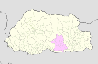
Menbi Gewog is a gewog of Lhuntse District, Bhutan.
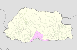
Phongmed Gewog is a gewog of Trashigang District, in the East of Bhutan.
| Central Bhutan Zone | ||
|---|---|---|
| Southern Bhutan Zone | ||
| Western Bhutan Zone | ||
| Eastern Bhutan Zone | ||
| Former Gewogs | ||
| | This Bhutan location article is a stub. You can help Wikipedia by expanding it. |