
Wangdue Phodrang District is a Thromde and dzongkhag (district) of central Bhutan. This is also the name of the dzong which dominates the district. The name is said to have been given by the Shabdrung Ngawang Namgyal who was searching for the best location for a dzong to prevent incursions from the south. The word "wangdue" means unification of Country, and "Phodrang" means Palace in Dzongkha.
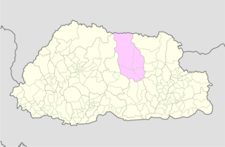
Bumthang District is one of the 20 dzongkhag (districts) comprising Bhutan. It contains numerous temples and Buddhist sacred sites. The district is divided into four gewogs, each corresponding to a major glacial valley: Choekor, Tang, Ura, and Chhume. The latter valley is also called Bumthang, lending its name to the whole district.
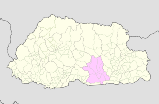
Zhemgang District, is one of the 20 dzongkhags (districts) comprising Bhutan. It is bordered by Sarpang, Trongsa, Bumthang, Mongar and Pemagatshel Districts, and borders Assam in India to the south. The administrative center of the district is Zhemgang.

A gewog, in the past also spelled as geog, is a group of villages in Bhutan. The head of a gewog is called a gup. Gewogs form a geographic administrative unit below dzongkhag districts, and above Dzongkhag Thromde class B and Yenlag Thromde municipalities. Dzongkhag Thromde class A municipalities have their own independent local government body.

Trongsa District is one of the districts of Bhutan. It is the most central district of Bhutan and the geographic centre of Bhutan is located within it at Trongsa Dzong.
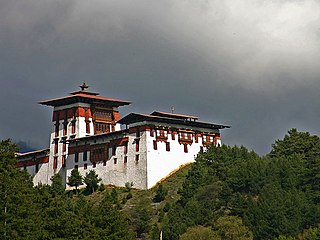
Jakar is a town in the central-eastern region of Bhutan. It is the district capital of Bumthang District and the location of Jakar Dzong, the regional dzong fortress. The name Jakar roughly translates as "white bird" in reference to its foundation myth, according to which a roosting white bird signalled the proper and auspicious location to found a monastery around 1549.

Bumthang Valley is the main inhabited valley in the Bumthang district of Bhutan.

The following outline is provided as an overview of and topical guide to Bhutan:
Dhur or D°ur is a town in western Chhoekhor Gewog, Bumthang District in central Bhutan.

Ura is a town in Ura Gewog in Bumthang District in northeastern Bhutan.
The Kurtöp language is an East Bodish language spoken in Kurtoe Gewog, Lhuntse District, Bhutan. In 1993, there were about 10,000 speakers of Kurtöp.
Chiwogs of Bhutan or chios refer to the 1044 basic electoral precincts of Bhutan. Chiwogs are also former third-level administrative divisions of Bhutan below gewogs. Until 2009, they were the equivalent of municipalities or parishes, containing clusters of villages and hamlets. There are generally 5 or 6 chios in each geo, and in turn several geos in each dzongkha (district). To illustrate, there are 50 chios in Paro District alone. The majority of chios are small rural communities; more densely populated areas tend to be separate thromdes, or municipalities. A Chiwog Disaster Management Plan (CDMP) exists in some chios to form an effective responsive to any local disasters. Often, participants in the CDMP are also trained at a geo level for better coordination.

Choekor Gewog is a gewog of Bumthang District, Bhutan.

Tang Gewog is a gewog of Bumthang District, Bhutan.

Ura Gewog is a gewog of Bumthang District, Bhutan. Ura Gewog consists of ten major villages- Tangsibi, Shingnyeer, Shingkhar, Pangkhar, Somthrang, Beteng, Trabi, Tarshong, Toepa and Chari with total household of 301 and population of 2288, covering an area of around 265 sq. kilometer with some 82% of forest coverage. The Gewog is located in the southeastern part of Bumthang District, 48 km distance from Dzongkhag Offices. It is bordered by Chhokhor and Chhumig gewog to the west, Tang gewog to the north, Zhemgang and Mongar District to the south and Lhuentse District to the east. The altitude of the gewog is around 3100 meters above sea level.
The Local Government Act of Bhutan was enacted on September 11, 2009, by parliament of Bhutan in order to further implement its program of decentralization and devolution of power and authority. It is the most recent reform of the law on Bhutan's administrative divisions: Dzongkhags, Dungkhags, Gewogs, Chiwogs, and Thromdes (municipalities). The Local Government Act of Bhutan has been slightly amended in 2014.
A Thromde is a second-level administrative division in Bhutan. The legal administrative status of thromdes was most recently codified under the Local Government Act of 2009, and the role of thromdes in elections in Bhutan was defined in the Election Act of 2008.

Khamdang Gewog is a gewog of Trashiyangtse District, Bhutan.

The Takpa or Dakpa language, Dakpakha, known in India as Tawang Monpa, also known as Brami in Bhutan, is an East Bodish language spoken in the Tawang district of Arunachal Pradesh, and in northern Trashigang District in eastern Bhutan, mainly in Kyaleng, Phongmed Gewog, Dangpholeng and Lengkhar near Radi Gewog. Van Driem (2001) describes Takpa as the most divergent of Bhutan's East Bodish languages, though it shares many similarities with Bumthang. SIL reports that Takpa may be a dialect of the Brokpa language and that it been influenced by the Dzala language whereas Brokpa has not.
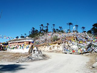
Thrumshing La, also called Thrumshingla Pass and Donga Pass,, is the second-highest mountain pass in Bhutan, connecting its central and eastern regions across the otherwise impregnable Donga range that has separated populations for centuries. It is located on a bend of the Lateral Road at the border of Bumthang District and Mongar District, along the border with Lhuntse District to the east. The Lateral Road bisects Thrumshingla National Park, named after the pass. The World Wildlife Fund also maintains operations in the park.
