| Talog Gewog རྟ་ལོག་ | |
|---|---|
| Gewog | |
 | |
| Country | |
| District | Punakha District |
| Time zone | BTT (UTC+6) |
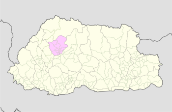
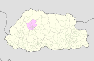
Talog Gewog (Dzongkha: རྟ་ལོག་) is a gewog (village block) of Punakha District, Bhutan. [1] [2]
| Talog Gewog རྟ་ལོག་ | |
|---|---|
| Gewog | |
| | |
| Country | |
| District | Punakha District |
| Time zone | BTT (UTC+6) |
Talog Gewog (Dzongkha: རྟ་ལོག་) is a gewog (village block) of Punakha District, Bhutan. [1] [2]

Wangdue Phodrang District is a dzongkhag (district) of central Bhutan. This is also the name of the dzong which dominates the district, and the name of the small market town outside the gates of the dzong. The name is said to have been given by the Shabdrung Ngawang Namgyal who was searching for the best location for a dzong to prevent incursions from the south. The word "wangdue" means unification of Country, and "Phodrang" means Palace in Dzongkha.

Bhutan comprises twenty districts.

Gasa District or Gasa Dzongkhag is one of the 20 dzongkhags (districts) comprising Bhutan. The northern part of Gasa District is a disputed zone under the control of the People's Republic of China. The capital of Gasa District is Gasa Dzong near Gasa. It is located in the far north of the county and spans the Middle and High regions of the Tibetan Himalayas. The dominant language of the district is Dzongkha, which is the national language. Related languages, Layakha and Lunanakha, are spoken by semi-nomadic communities in the north of the district.
A dzongkhag is an administrative and judicial district of Bhutan. The twenty dzongkhags of Bhutan are further divided into 205 gewogs. Some larger dzongkhags have one or more of an intermediate judicial division, known as dungkhags (sub-districts), which themselves comprise two or more gewogs. The Parliament of Bhutan passed legislation in 2002 and 2007 on the status, structure, and leadership of local governments, including dzongkhags. Its most recent legislation regarding dzongkhags is the Local Government Act of 2009. A dzongkhag is headed by a dzongdag, who is an elected official.

A gewog, in the past also spelled as geog, refers to a group of villages in Bhutan. The head of a gewog is called a gup. Gewogs form a geographic administrative unit below dzongkhag districts, and above Dzongkhag Thromde class B and Yenlag Thromde municipalities. Dzongkhag Thromde class A municipalities have their own independent local government body.
Chiwogs of Bhutan or chios refer to the 1044 basic electoral precincts of Bhutan. Chiwogs are also former third-level administrative divisions of Bhutan below geos. Until 2009, they were the equivalent of municipalities or parishes, containing clusters of villages and hamlets. There are generally 5 or 6 chios in each geo, and in turn several geos in each dzongkha (district). To illustrate, there are 50 chios in Paro District alone. The majority of chios are small rural communities; more densely populated areas tend to be separate thromdes, or municipalities. A Chiwog Disaster Management Plan (CDMP) exists in some chios to form an effective responsive to any local disasters. Often, participants in the CDMP are also trained at a geo level for better coordination.
Toepisa Gewog is a gewog of Punakha District, Bhutan. It used to be part of Thimphu District.
Chhubug Gewog is a gewog of Punakha District, Bhutan.
Dzomi Gewog is a gewog of Punakha District, Bhutan.
Goenshari Gewog is a gewog of Punakha District, Bhutan.
Guma Gewog is a gewog of Punakha District, Bhutan.
Kabisa Gewog is a gewog of Punakha District, Bhutan.
Lingmukha Gewog is a gewog of Punakha District, Bhutan.
Shenga Bjemi Gewog is a gewog of Punakha District, Bhutan.
Toewang Gewog is a gewog of Punakha District, Bhutan.
The Local Government Act of Bhutan was enacted on September 11, 2009, by parliament of Bhutan in order to further implement its program of decentralization and devolution of power and authority. It is the most recent reform of the law on Bhutan's administrative divisions: Dzongkhags, Dungkhags, Gewogs, Chiwogs, and Thromdes (municipalities). The Local Government Act of Bhutan has been slightly amended in 2014.
Barp Gewog is a gewog of Punakha District, Bhutan.
The glaciers of Bhutan, which covered about 10 percent of the total surface area in the 1980s, are an important renewable source of water for Bhutan's rivers. Fed by fresh snow each winter and slow melting in the summer, the glaciers bring millions of litres of fresh water to Bhutan and downriver areas each year. Glacial melt also adds to monsoon-swollen rivers which may be a contributing factor to flooding. Where glacial movement temporary blocks riverflows, downstream areas may be threatened by glacial lake outburst flood ("GLOFs"). Although GLOFs are not a new phenomenon in Bhutan, their frequency has risen in the past three decades. Significant GLOFs occurred in 1957, 1960, 1968 and 1994, devastating lives and property downstream. According to the Bhutan Department of Energy however, the majority of rivers in Bhutan are more susceptible to fluctuation with changing rainfall patterns than to flooding directly attributable to glacier or snow melt.

Laya is a Tibetic variety spoken by indigenous Layaps inhabiting the high mountains of northwest Bhutan in the village of Laya, Gasa District. Speakers also inhabit the northern regions of Thimphu and Punakha Districts. Its speakers are ethnically related to the Tibetans. Most speakers live at an altitude of 3,850 metres (12,630 ft), just below the Tsendagang peak. Laya speakers are also called Bjop by the Bhutanese, sometimes considered a condescending term. There were 1,100 speakers of Laya in 2003.
| Central Bhutan Zone | ||
|---|---|---|
| Southern Bhutan Zone | ||
| Western Bhutan Zone | ||
| Eastern Bhutan Zone | ||
| Former Gewogs | ||
| This Bhutan location article is a stub. You can help Wikipedia by expanding it. |