Clyde River, Nova Scotia

Last updated

Clyde River
Quinns Road, Upper and Lower Clyde, Port Clyde, Oak Lane, Pulp Mill Road and many other small places.
ClydeRiver NS FullFlow.jpg
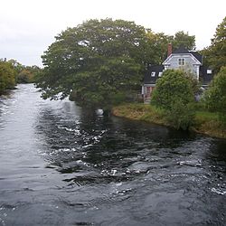
Clyde River shares its name with the river which runs through it
Canada Nova Scotia location map 2.svg
Red pog.svg
Clyde River
Location of Clyde River, Nova Scotia
Coordinates: 43°37′55″N65°28′50″W / 43.631944°N 65.480556°W / 43.631944; -65.480556 [1]
Country Flag of Canada (Pantone).svg  Canada
Province Flag of Nova Scotia.svg  Nova Scotia
County Shelburne
Municipal district Shelburne
Population
 (2006) [2]
  Total1,836
  Change (2001-06)
Decrease2.svg2.7%
Time zone UTC-4 (AST)
  Summer (DST) UTC-3 (ADT)
Postal code(s)
Area code 902
Access Routes
Nova Scotia 103.svg Hwy 103

Nova Scotia Route 309.svg Route 309

Clyde River is a community in the Canadian province of Nova Scotia, located in the Shelburne municipal district of Shelburne County. It borrows its name from the Clyde River which flows through the community, which was in turn adopted from the famous Scottish river. The area was settled by New England Planters about 1667 and later by Loyalists after 1783. Lumbering and farming were the initial industries. [1] In 1847 there were 15 Mi'kmaq families living in the Clyde River area. [3]

See also

Related Research Articles

<span class="mw-page-title-main">Shelburne, Nova Scotia</span> Town in Nova Scotia, Canada

Shelburne is a town located in southwestern Nova Scotia, Canada.

<span class="mw-page-title-main">Municipality of the District of Barrington</span> District municipality in Nova Scotia, Canada

Barrington, officially named the Municipality of the District of Barrington, is a district municipality in western Shelburne County, Nova Scotia, Canada. Statistics Canada classifies the district municipality as a municipal district.

Sandy Point is a community in the Canadian province of Nova Scotia, located in the Shelburne municipal district of Shelburne County.

Cape Sable Island, locally referred to as Cape Island, is a small Canadian island at the southernmost point of the Nova Scotia peninsula. It is sometimes confused with Sable Island. Historically, the Argyle, Nova Scotia region was known as Cape Sable and encompassed a much larger area than simply the island it does today. It extended from Cape Negro through Chebogue.

<span class="mw-page-title-main">Municipality of the District of Shelburne</span> District municipality in Nova Scotia, Canada

District of Shelburne, officially named the Municipality of the District of Shelburne, is a district municipality comprising the eastern section of Shelburne County, Nova Scotia, Canada, but does not include the Towns of Shelburne or Lockeport. Statistics Canada classifies the district municipality as a municipal district. It is home to the Bowers Meadows Wilderness Area.

The Tobeatic Wilderness Area is the largest protected area in the Canadian Maritimes, located in southwestern Nova Scotia. It contains nearly 120,000 hectares of land and spans parts of five counties, Annapolis, Digby, Queens, Shelburne and Yarmouth. Located adjacent to Kejimkujik National Park, it was formerly known as the Tobeatic Wildlife Management Area, and the Tobeatic Game Reserve.

<span class="mw-page-title-main">Clark's Harbour</span> Town in Nova Scotia, Canada

Clark's Harbour is a town on Cape Sable Island in southwestern Nova Scotia, Canada, located in Shelburne County. The main industry is lobster fishing. Owing to this as well as the town's history as a fishing community, the town is noted as the birthplace of the Cape Islander fishing boat.

<span class="mw-page-title-main">Tusket</span>

Tusket is a small fishing community located in Yarmouth County, Nova Scotia on route 308.

Barrington is an unincorporated Canadian rural community of about 4,000 people on the northeast corner of Barrington Bay in Shelburne County, Nova Scotia.

Barrington Head is a locality in the Canadian province of Nova Scotia, located in the Municipality of the District of Barrington of Shelburne County.

<span class="mw-page-title-main">Birchtown, Nova Scotia</span> Community in Nova Scotia, Canada

Birchtown is a community and National Historic Site in the Canadian province of Nova Scotia, located near Shelburne in the Municipal District of Shelburne County. Founded in 1783, the village was the largest settlement of Black Loyalists and the largest free settlement of ethnic Africans in North America in the eighteenth century. The two other significant Black Loyalist communities established in Nova Scotia were Brindley town and Tracadie. Birchtown was named after British Brigadier General Samuel Birch, an official who helped lead the evacuation of Black Loyalists from New York.

Port La Tour is a community in the Canadian province of Nova Scotia, located in the Municipality of the District of Barrington of Shelburne County.

Eel Bay, previously known as Cape Negro, is a community in the Canadian province of Nova Scotia, located in the Municipality of the District of Barrington of Shelburne County. Cape Sable, Nova Scotia By one account, Eel Bay was first settled by the French who migrated from Port Royal in 1620. However other records indicate the habitation and garden of a French Priest at the Hawl Over in Eel Bay as early as 1635, and the 1671 French census records the family of Amand and Elizabeth Lalloue living in Eel Bay.

Port Clyde is a community in the Canadian province of Nova Scotia, located in the Shelburne Municipal District of Shelburne County.

Upper Clyde River is a community of the Municipality of the District of Shelburne in the Canadian province of Nova Scotia.

Carleton Village is a community in the Canadian province of Nova Scotia, located in the Shelburne municipal district of Shelburne County. The community is named after Sir Guy Carleton.

Lower Clyde River is a community in the Shelburne County, Nova Scotia, Canada.

<span class="mw-page-title-main">CFS Shelburne</span>

Canadian Forces Station (CFS) Shelburne is a former Canadian Forces Station that was a shore terminus for the Sound Surveillance System (SOSUS) from 1955 to 1994. It was located in the Municipality of the District of Shelburne, Shelburne County, Nova Scotia.

<span class="mw-page-title-main">Southern Nova Scotia</span> Economic Region in Nova Scotia, Canada

Southern Nova Scotia or the South Shore is a region of Nova Scotia, Canada. The area has no formal identity and is variously defined by geographic, county and other political boundaries. Statistics Canada, defines Southern Nova Scotia as an economic region, composed of Lunenburg County, Queens County, Shelburne County, Yarmouth County, and Digby County. According to Statistics Canada, the region had the highest decrease of population in Canada from 2009 to 2010, with a population decrease of 10.2 residents per thousand. The region also has the second-highest median age in Canada at 47.1 years old.

<span class="mw-page-title-main">Township (Nova Scotia)</span> Former division of Nova Scotia

A township in Nova Scotia, Canada, was an early form of land division and local administration during British colonial settlement in the 18th century. They were created as a means of populating the colony with people loyal to British rule. They were typically rural or wilderness areas of around 100,000 acres (400 km2) that would eventually include several villages or towns. Some townships, but not all, returned a member to the General Assembly of Nova Scotia; others were represented by the members from the county. Townships became obsolete by 1879 by which time towns and counties had become incorporated.

References


43°37′55″N65°28′50″W / 43.63194°N 65.48056°W / 43.63194; -65.48056 (Clyde River, Nova Scotia)