
Mount Galatea is the highest peak of the Kananaskis Range, a subrange of the Canadian Rockies in the province of Alberta. It is located in the upper Spray Lakes Valley of the Kananaskis Country system of provincial parks. The mountain was named after the Royal Navy cruiser HMS Galatea.

Mount Whyte is a mountain in Alberta, Canada located in Banff National Park, near Lake Louise. The mountain can be seen from the Trans-Canada Highway, and offers views of the Valley of the Ten Peaks, including the Chateau Lake Louise. The mountain is also visible from the hiking trail that skirts the northern shore of Lake Agnes.

Mount Engadine is a 2,972-metre (9,751-foot) mountain summit located in the Spray River Valley of Kananaskis Country, in the Canadian Rockies of Alberta, Canada. It was named in 1917 after HMS Engadine, a seaplane tender of the Royal Navy present at the Battle of Jutland during World War I. The mountain is located in the Kananaskis Range in Alberta.

Mount Birdwood is a 3,097-metre (10,161-foot) summit in the Spray Mountains range of the Canadian Rockies in Alberta, Canada. The mountain is situated on the east boundary of Banff National Park in the upper Spray Lakes River Valley.
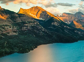
Mount Boswell is a 2,454-metre (8,051-foot) summit located in Waterton Lakes National Park, in the Canadian Rockies of Alberta, Canada. It is situated along the east shore of Waterton Lake, one kilometre north of the Canada–United States border. Its nearest higher peak is Miche Wabun Peak, 5.0 km (3.1 mi) to the southeast.

Eiffel Peak is a 3,077-metre (10,095-foot) mountain summit in Banff National Park in Alberta, Canada. It's part of the Bow Range, which is a sub-range of the Canadian Rockies. The nearest higher peak is Mount Temple, 3.0 km (1.9 mi) to the northeast.

Windtower is a 2,695-metre (8,842-foot) tower-like summit located in the Wind Valley of Kananaskis Country in the Canadian Rockies of Alberta, Canada. Its nearest higher peak is Mount Lougheed, 3.0 km (1.9 mi) to the southeast. Windtower is a conspicuous landmark that can be seen from Highway 1, the Trans-Canada Highway in the Canmore area. Although not of remarkable elevation, the mountain has an imposing, overhanging north face with an appearance similar to peaks in The Bugaboos.

Mount Kidd is a 2,958-metre (9,705-foot) double-summit massif centrally located in Kananaskis Country in the Canadian Rockies of Alberta, Canada. Mount Kidd is situated within Spray Valley Provincial Park, and its nearest higher neighbor is Mount Sparrowhawk, 7.0 km (4.3 mi) to the northwest. Mount Kidd is a landmark that can be seen from Highway 40 in the Kananaskis Village area, and from the Kananaskis Country Golf Course which lies at the eastern base of the mountain.

Mount Nestor is a 2,970-metre (9,740 ft) mountain summit located in Kananaskis Country in the Canadian Rockies of Alberta, Canada. It is named after HMS Nestor, a destroyer sunk in the Battle of Jutland during World War I. Mount Nestor is situated at the south end of the Goat Range along the west shore of Spray Lakes Reservoir. Nestor's east flank is within Spray Valley Provincial Park, while the west aspect is within Banff National Park, with the boundary line between the two parks running roughly north-to-south over its summit. The nearest higher peak is Old Goat Mountain, 2.0 km (1.2 mi) to the north. Mount Nestor can be seen from Alberta Highway 742, the Smith-Dorrien/Spray Trail.

Mount Lougheed is a 3,107-metre (10,194-foot) triple-peak mountain located between Spray Lakes Reservoir and the Wind Valley of Kananaskis Country in the Canadian Rockies of Alberta, Canada. The highest summit is known as Peak 2. Peak 1 to the northwest is 3,080 metres. Peak 3 to the southeast is 3,010 metres. The nearest higher peak is Wind Mountain, 2.0 km (1.2 mi) to the southeast. Mount Lougheed is a conspicuous landmark that can be seen from Highway 1, the Trans-Canada Highway at Dead Man's Flats which is east of Canmore.
Old Goat Mountain is a 3,120-metre (10,240 ft) mountain summit located in Kananaskis Country of Alberta, Canada.

Mount Sparrowhawk is a 3,121-metre (10,240 ft) mountain summit located in Kananaskis Country in the Canadian Rockies of Alberta, Canada. Mount Sparrowhawk's nearest higher peak is Mount Bogart, 3.6 km (2.2 mi) to the southeast. Sparrowhawk's south slope was a candidate to be used as a ski hill for the alpine events at the 1988 Winter Olympics, but nearby Mount Allan's Nakiska was selected instead.

Mount French is a 3,244-metre (10,643-foot) summit in the Spray Mountains range of the Canadian Rockies in Alberta, Canada. The mountain is situated in Peter Lougheed Provincial Park of Kananaskis Country. French is the second highest point in the Spray Mountains Range. Its nearest higher peak, and highest in the Spray Range, is Mount Sir Douglas, 3.0 km (1.9 mi) to the west. Mount French can be seen from Alberta Highway 742, the Smith-Dorrien/Spray Trail.

Mount Turner is a 2,806-metre (9,206-foot) mountain summit located in the upper Spray River Valley of southern Banff National Park, in the Canadian Rockies of Alberta, Canada. Mount Turner in not visible from any road in Banff Park, however, it can be seen from Alberta Highway 742, also known as the Smith-Dorrien/Spray Trail in Kananaskis Country. Mount Turner's nearest higher peak is Cone Mountain, 2.91 km (1.81 mi) to the north.

Mount Shark is a 2,786-metre (9,140-foot) mountain summit located in the Spray Valley of Kananaskis Country at the northern tip of the Spray Mountains range. It is situated on the southern boundary of Banff National Park in the Canadian Rockies of Alberta, Canada. Mount Shark in not visible from any road in Banff Park, however, it can be seen from Alberta Highway 742, also known as the Smith-Dorrien/Spray Trail. Mount Shark's nearest higher peak is Mount Smuts, 3.0 km (1.9 mi) to the southeast.

Mount Smuts is a 2,938-metre (9,639-foot) mountain summit located in the Canadian Rockies of Alberta, Canada. It is set in the Spray Valley near the northern end of the Spray Mountains range. It is situated on the common boundary shared by Peter Lougheed Provincial Park with Banff National Park. Mount Smuts is not visible from any road in Banff Park, however it can be seen from Alberta Highway 742, also known as Smith-Dorrien/Spray Trail in Kananaskis Country. Mount Smuts' nearest higher neighbor is Mount Birdwood, 2.8 km (1.7 mi) to the south-southeast.

Mount Morrison is a 2,765-metre (9,072-foot) mountain summit located in the upper Spray River Valley of southern Banff National Park, in the Canadian Rockies of Alberta, Canada. Mount Morrison in not visible from any road in Banff Park, however, it can be seen from Alberta Highway 742, also known as the Smith-Dorrien/Spray Trail in Kananaskis Country. Mount Morrison's nearest higher peak is Mount Turner, 1.8 km (1.1 mi) to the north.
Mount Murray is a 3,026-metre (9,928-foot) mountain summit in the Spray Mountains range of the Canadian Rockies in Alberta, Canada. The mountain is situated in Peter Lougheed Provincial Park of Kananaskis Country. Its nearest higher peak is Mount French, 2.0 km (1.2 mi) to the south-southwest. Mount Murray can be seen from Alberta Highway 742, the Smith-Dorrien/Spray Trail.
Mount Parrish is a 2,530-metre (8,301-foot) mountain summit located in Alberta, Canada.

Mount Head is a 2,782-metre (9,127-foot) mountain summit located in Alberta, Canada.


