Mount Smuts

Last updated
Mount Smuts
Mount Smuts West Aspect.jpg
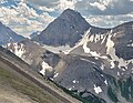
West aspect of Mount Smuts
Highest point
Elevation 2,938 m (9,639 ft) [1] [2]
Prominence 591 m (1,939 ft) [1]
Parent peak Mount Birdwood (3,097 m) [1]
Isolation 2.8 km (1.7 mi) [3]
Listing Mountains of Alberta
Coordinates 50°48′28″N115°23′13″W / 50.80778°N 115.38694°W / 50.80778; -115.38694 [4]
Geography
Canada Alberta relief location map - transverse mercator proj.svg
Red triangle with thick white border.svg
Mount Smuts
Location in Alberta
Canada relief map 2.svg
Red triangle with thick white border.svg
Mount Smuts
Mount Smuts (Canada)
Mount Smuts
Interactive map of Mount Smuts
Country Canada
Province Alberta
Parent range Spray Mountains
Canadian Rockies-
Topo map NTS   82J14 Spray Lakes Reservoir [4]
Geology
Rock age Cambrian
Rock type Limestone
Climbing
First ascent 1926 M. Crosby, M. Kennard, H. S. Crosby, C. A. Willard, Rudolph Aemmer [1]
Easiest route Scramble [2]

Mount Smuts is a 2,938-metre (9,639-foot) mountain summit located in the Canadian Rockies of Alberta, Canada. It is set in the Spray Valley near the northern end of the Spray Mountains range. It is situated on the common boundary shared by Peter Lougheed Provincial Park with Banff National Park. Mount Smuts is not visible from any road in Banff Park, however it can be seen from Alberta Highway 742, also known as Smith-Dorrien/Spray Trail in Kananaskis Country. Mount Smuts' nearest higher neighbor is Mount Birdwood, 2.8 km (1.7 mi) to the south-southeast. [1]

Contents

History

Mount Smuts was named by the Interprovincial Boundary Commission in 1918 for General (later Field Marshal) Jan Smuts (1870–1950), a noted South African and British Imperial statesman and mountaineer. [5] During World War I, he led the armies of South Africa against Germany, capturing German South-West Africa and commanding the British Army in East Africa in 1916-1917. [6] [7]

The mountain's toponym was officially adopted in 1924 by the Geographical Names Board of Canada. [4]

The first ascent of the peak was made in 1926 by M. Crosby, M. Kennard, H. S. Crosby, C. A. Willard, with guide Rudolph Aemmer. [7]

Geology

Mount Smuts is composed of sedimentary rock laid down during the Precambrian to Jurassic periods. [8] Formed in shallow seas, this sedimentary rock was pushed east and over the top of younger rock during the Laramide orogeny. [9]

Climate

Based on the Köppen climate classification, Mount Smuts is located in a subarctic climate zone with cold, snowy winters, and mild summers. [10] Winter temperatures can drop below −20 °C with wind chill factors below −30 °C. In terms of favorable weather, July through September are the best months to climb. Precipitation runoff from the mountain drains west into Spray River, or east to Smuts Creek, both of which empty into Spray Lakes Reservoir.

Climbing

Mount Smuts is a difficult and exposed scramble on limestone slabs via the south ridge, and very few parties successfully summit each year. [2] Rope is recommended for anything less than ideal conditions.

See also

References

  1. 1 2 3 4 5 "Mount Smuts". Bivouac.com. Retrieved 2018-12-31.
  2. 1 2 3 Alan Kane (1999). "Mount Smuts". Scrambles in the Canadian Rockies . Rocky Mountain Books. pp. 110–111. ISBN   0-921102-67-4.
  3. "Mount Smuts, Alberta". Peakbagger.com. Retrieved 2021-02-24.
  4. 1 2 3 "Mount Smuts". Geographical Names Data Base . Natural Resources Canada . Retrieved 2018-12-31.
  5. Imperial ecology: environmental order in the British Empire, 1895–1945, Peder Anker Publisher: Harvard University Press, 2001 ISBN   0-674-00595-3
  6. Place-names of Alberta. Ottawa: Geographic Board of Canada. 1928. p. 117.
  7. 1 2 "Mount Smuts". cdnrockiesdatabases.ca. Retrieved 2019-10-08.
  8. Belyea, Helen R. (1960). The Story of the Mountains in Banff National Park (PDF). parkscanadahistory.com (Report). Ottawa: Geological Survey of Canada. Archived (PDF) from the original on 2015-10-02. Retrieved 2019-09-13.
  9. Gadd, Ben (2008). Geology of the Rocky Mountains and Columbias.
  10. Peel, M. C.; Finlayson, B. L.; McMahon, T. A. (2007). "Updated world map of the Köppen−Geiger climate classification". Hydrol. Earth Syst. Sci. 11 (5): 1633–1644. Bibcode:2007HESS...11.1633P. doi: 10.5194/hess-11-1633-2007 . ISSN   1027-5606.