
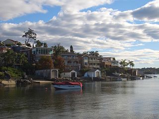
Como is a suburb in southern Sydney, located on the southern banks of the Georges River, in the state of New South Wales, Australia. It is located 27 kilometres (17 mi) south of the Sydney central business district in the local government area of the Sutherland Shire. The postcode is 2226, which it shares with neighboring suburbs Jannali, Bonnet Bay, and Como West. The postal locality (suburb) of Como West was originally created in 1939 from within the greater Como locality and is bounded to the west by the Woronora River. The shoreline across Como features Bonnet Bay, Scylla Bay and Carina Bay.

Waterfall is a small suburb in southern Sydney, in the state of New South Wales, Australia. It is 40 kilometres south of the Sydney central business district in the Sutherland Shire. It is the southernmost suburb of Sydney in the eastern corridor, bordering the Illawarra region.

Lucas Heights is a suburb in southern Sydney, in the state of New South Wales, Australia. It is near to the Royal National Park.

Oatley is a suburb in Southern Sydney in the state of New South Wales, Australia. It is located 18 kilometres south of the Sydney central business district and is part of the St George area. Oatley lies in the local government area of Georges River Council. It lies on the northern side of the tidal estuary of the Georges River and its foreshore includes part of Oatley Bay and Lime Kiln Bay, and all of Neverfail Bay, Gungah Bay and Jewfish Bay.

The Eastern Suburbs & Illawarra Line is a commuter railway line in the eastern and southern suburbs of Sydney and is a part of the Sydney Trains network. The line was constructed in the 1880s to Wollongong to take advantage of agricultural and mining potentials in the Illawarra area. In March 1926, it became the first railway in New South Wales to run electric train services.

The Sutherland Shire is a local government area in the southern region of Sydney, in the state of New South Wales, Australia. The Sutherland Shire comprises an area of 370 square kilometres (140 sq mi) and as at the 2016 census had an estimated population of 218,464. Sutherland Shire is colloquially known as "The Shire" and has featured in several reality television series.

The St George region of Sydney is part of the southern suburbs of Sydney, in the state of New South Wales, Australia. The area includes all the suburbs in the local government area of Georges River Council and the part of Bayside Council which was Rockdale City prior to 2016. The eastern boundary of the district is Lady Robinson Beach on Botany Bay. The name "St George" derives from the cadastral Parish of St George, and the area was later covered by the St George County Council, the electricity supplier for the councils in this region.

The South Coast Railway is a commuter and goods railway line from Sydney to Wollongong and Bomaderry in New South Wales, Australia. Beginning at the Illawarra Junction, the line services the Illawarra and South Coast regions of New South Wales.

Miranda railway station is located on the Cronulla line, serving the Sydney suburb of Miranda. It is served by Sydney Trains T4 line services.

Illawong is a suburb in southern Sydney, in the state of New South Wales, Australia. Illawong is located 27 kilometres south of the Sydney Central Business District, in the local government area of the Sutherland Shire in the area commonly called Menai. The post code is 2234, which is also assigned to the contiguous suburbs of Menai, Bangor Barden Ridge and Alfords Point.

Barden Ridge is a suburb in southern Sydney, in the state of New South Wales, Australia. Barden Ridge is located 29 kilometres south of the Sydney central business district in the local government area of the Sutherland Shire. Barden Ridge is colloquially known to locals as 'The Ridge'.

Woronora Heights is a suburb in southern Sydney, in the state of New South Wales, Australia. Woronora Heights is located 29 kilometres south of the Sydney central business district, in the local government area of the Sutherland Shire. Woronora is a separate suburb, to the north. Most streets in Woronora Heights are named after birds.
Sylvania is a suburb in southern Sydney, New South Wales, Australia, 22 kilometres south of the Sydney central business district in the Sutherland Shire. It is well known for its large waterfront properties and restaurants.

Mortdale is a suburb located in southern Sydney, in the state of New South Wales, Australia. Mortdale is located 20 kilometres south of the Sydney central business district and is part of the St George area. Mortdale is situated in the local government area of Georges River Council. Mortdale extends south to Lime Kiln Bay, on the Georges River. Mortdale Heights is a locality in the western corner of the suburb.
Loftus is a suburb, in southern Sydney, in the state of New South Wales, Australia. Loftus is 29 kilometres south of the Sydney central business district, in the local government area of the Sutherland Shire.

Engadine is a suburb in southern Sydney, in the state of New South Wales, Australia. Engadine is located 33 kilometres (21 mi) south of the Sydney central business district, in the local government area of the Sutherland Shire.

Sutherland railway station is located on the Illawarra line, serving the Sydney suburb of Sutherland. It is served by Sydney Trains T4 line services and NSW TrainLink South Coast line services.
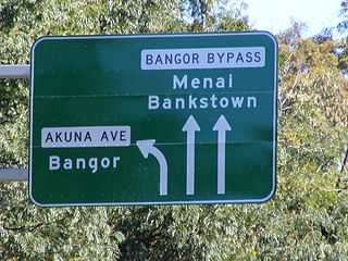
The Bangor Bypass is a road in New South Wales, Australia, between New Illawarra Road and River Road, bypassing Bangor and Menai. Completed in February 2005, it replaced Menai Road as the main road between A6 and River Road, alleviating traffic on Menai Road and increasing travel speed through Bangor and Menai. It also acts as a western extension of River Road and Woronora Bridge, which was completed four years earlier in 2001. A section of New Illawarra Road north of the bypass was also completed as part of the project, linking the bypass directly to Alfords Point Road.
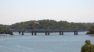
The Como railway bridge carries the Illawarra railway line across the Georges River between the Sydney suburbs of Oatley and Como.