Alfords Point, New South Wales

Last updated

Alfords Point
Sydney,  New South Wales
Alfords Point Bridge.JPG
Alfords Point Bridge over Georges River
Alfords Point, New South Wales
Population3,109 (2016 census) [1]
Postcode(s) 2234
Elevation98 m (322 ft)
Location28 km (17 mi) SW of Sydney CBD
LGA(s) Sutherland Shire
State electorate(s) Miranda
Federal division(s) Hughes
Suburbs around Alfords Point:
Picnic Point Revesby Heights Padstow Heights
Holsworthy Alfords Point Lugarno
Menai Illawong Illawong

Alfords Point is a suburb in southern Sydney, in the state of New South Wales, Australia. Alfords Point is 28 kilometres south of the Sydney central business district, within the local government area of the Sutherland Shire. Alfords Point shares the postcode of 2234 with neighbouring suburbs of Menai, Bangor and Illawong.

Contents

Alfords Point is on the southern bank of the Georges River. The suburb is nearly completely surrounded by bushland from the Georges River nature Reserve and with Alfords Point Road within its eastern border running south to north onto the Alfords Point Road Bridge across the Georges River towards Padstow. Brushwood Drive is the only road to enter and exit Alfords Point.

History

Jane Alford, widow of John Alford Senior owned 50 acres (200,000 m2) of land near here in 1828. Alford was originally the name given to an area of public reserve on the bank of the Georges River. [2]

When the Sutherland Shire was officially formed in 1906, the western boundary extended to what is today called Menai (then called Bangor). In 1922, a proclamation was made to allow for an adjustment of the shire boundaries and include the areas which are now Illawong and Alfords Point. The area was formerly attached to the Municipality of Hurstville. [3] Modern Alfords Point began to develop alongside the Menai Town Centre initiative in the late 1970s-1980s with large plots of bushland divided for housing development.

The Alfords Point Bridge was built across the Georges River connecting the Sutherland Shire with Canterbury-Bankstown. This connected the suburbs of Alfords Point and Padstow Heights. The first bridge opened on 7 September 1973, which only accommodated three lanes. The second bridge was built next to it, opening on 22 August 2008, making it three lanes north and three lanes south.

Alfords Point residents have been victim to bushfires, perhaps the most infamous being those of the 1994 Eastern seaboard fires which claimed many homes in the area, particularly those directly neighbouring the Georges River National Park. Other recent bushfires in the area occurred in Summer 1997–98 and Summer 2001–2002, however, damage to property was limited due to improved bush prevention as a result of the 1993–94 disaster.

Demographics

According to the 2016 census of Population, there were 3,109 people in Alfords Point. 76.1% of people were born in Australia. 76.9% of people only spoke English at home. Other languages spoken at home included Greek 7.4% and Arabic 4.6%. The most common responses for religious affiliation were Catholic 32%, Orthodox 16.1%, Anglican 14.6% and No Religion 13.1%. [1]

Commercial area

Alfords Point has a small group of shops on Brushwood Drive adjacent to Alfords Point Public School. Shops include a hair salon, pharmacy, convenience store, Charcoal Chicken & Pizza take-away and the Menai Dance Centre.

Sport and recreation

Alfords Point contains two sporting ovals, one named Casuarina Road Oval positioned on Casuarina Road and the other named Narina Park positioned on Coachwood Crescent, which are used for soccer and cricket in local competitions. Narina Park also hosts the Alfords Point Community Centre, which can be hired out from Sutherland Shire Council. Natural bushland is abundant in this area, as Alfords Point is positioned on the shores of the Georges River and National Park, with many walking tracks and firetrails popular amongst locals in summer.

Education

Alfords Point Primary school K-6 is a community-oriented school that often hosts community events and functions. [4] Alfords Point Pre-School Kindergarten, an early learning centre, is located opposite the shops. [5]

Street names

The street theme of Alfords Point is types of flora; trees and shrubs. Examples include: Brushwood Drive, Lavender Place, Eucalyptus Street. [6]

Notable residents

Related Research Articles

<span class="mw-page-title-main">Bangor, New South Wales</span> Suburb of Sydney, New South Wales, Australia

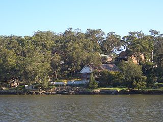
Bangor is a suburb in southern Sydney, in the state of New South Wales, Australia. Bangor is located 28 kilometres south of the Sydney central business district, in the local government area of the Sutherland Shire in the area commonly called Menai. Bangor sits south of the Georges River and to the west of the Woronora River.

<span class="mw-page-title-main">Caringbah</span> Suburb of Sydney, New South Wales, Australia

Caringbah is a suburb in Southern Sydney, in the state of New South Wales, Australia. Caringbah is 24 kilometres (15 mi) south of the Sydney central business district in the local government area of Sutherland Shire.

<span class="mw-page-title-main">A6 (Sydney)</span>

The A6 is a route designation of a major metropolitan arterial route through suburban Sydney, linking Cumberland Highway at Carlingford and Princes Highway at Heathcote, via Lidcombe and Bankstown. This name covers a few consecutive roads and is widely known to most drivers, but the entire allocation is also known – and signposted – by the names of its constituent parts: Marsden Road, Stewart Street, Kissing Point Road, Silverwater Road, St Hilliers Road, Boorea Street, Olympic Drive, Joseph Street, Rookwood Road, Stacey Street, Fairford Road, Davies Road, Alfords Point Road, New Illawarra Road and Heathcote Road.

<span class="mw-page-title-main">Sutherland Shire</span> Local government area in New South Wales, Australia

Sutherland Shire is a local government area in the southern region of Sydney, in the state of New South Wales, Australia. Sutherland Shire comprises an area of 370 square kilometres (140 sq mi) and as at the 2016 census had an estimated population of 218,464. Sutherland Shire is colloquially known as "The Shire" and has featured in several reality television series.

<span class="mw-page-title-main">Menai, New South Wales</span> Suburb of Sydney, New South Wales, Australia

Menai is a suburb in southern Sydney, in the state of New South Wales, Australia 29 kilometres south of the Sydney central business district in the local government area of the Sutherland Shire.

<span class="mw-page-title-main">Padstow, New South Wales</span> Suburb of City of Canterbury-Bankstown, New South Wales, Australia

Padstow, a suburb of local government area City of Canterbury-Bankstown, is located 21 kilometres south-west of the Sydney central business district, in the state of New South Wales, Australia, and is a part of the South-western Sydney region. Padstow is a mostly residential suburb bounded on the north by Bankstown and on the east by Salt Pan Creek, which is a stream feeding into the Georges River. The M5 South Western Motorway traverses the northern end of the suburb, which is also the location of a number of light industrial facilities.

<span class="mw-page-title-main">Grays Point, New South Wales</span> Suburb of Sydney, New South Wales, Australia

Grays Point is a small suburb in Southern Sydney, in the state of New South Wales, Australia 29 kilometres south of the Sydney central business district, in the local government area of the Sutherland Shire.

<span class="mw-page-title-main">Illawong</span> Suburb of Sydney, New South Wales, Australia

Illawong is a suburb in southern Sydney, in the state of New South Wales, Australia. Illawong is located 27 kilometres south of the Sydney Central Business District, in the local government area of the Sutherland Shire in the area commonly called Menai. The post code is 2234, which is also assigned to the contiguous suburbs of Menai, Bangor Barden Ridge and Alfords Point.

<span class="mw-page-title-main">Barden Ridge, New South Wales</span> Suburb of Sydney, New South Wales, Australia

Barden Ridge is a suburb in southern Sydney, in the state of New South Wales, Australia. Barden Ridge is located 29 kilometres south of the Sydney central business district in the local government area of the Sutherland Shire. Barden Ridge is colloquially known to locals as 'The Ridge'.

<span class="mw-page-title-main">Woronora</span> Suburb of Sydney, New South Wales, Australia

Woronora is a suburb in southern Sydney, in the state of New South Wales, Australia. Woronora is located 27 kilometres south of the Sydney central business district, in the local government area of the Sutherland Shire. Woronora Heights is a separate suburb, to the south-west.

<span class="mw-page-title-main">Sylvania, New South Wales</span> Suburb of Sydney, New South Wales, Australia

Sylvania is a suburb in southern Sydney, New South Wales, Australia, 22 kilometres south of the Sydney central business district in the Sutherland Shire. It is well known for its large waterfront properties and restaurants.

<span class="mw-page-title-main">Sandy Point, New South Wales</span> Suburb of Sydney, New South Wales, Australia

Sandy Point is a suburb in south-western Sydney, in the state of New South Wales, Australia 28 km south of the Sydney central business district, in the local government area of the Sutherland Shire.

<span class="mw-page-title-main">Oyster Bay, New South Wales</span> Suburb of Sydney, New South Wales, Australia

Oyster Bay is a suburb in Southern Sydney, in the state of New South Wales, Australia. It is located 26 kilometres south of the Sydney central business district in the local government area of the Sutherland Shire.

<span class="mw-page-title-main">Padstow Heights</span> Suburb of Sydney, New South Wales, Australia

Padstow Heights, a suburb of local government area of the City of Canterbury-Bankstown, located 22 kilometres south-west of the Sydney central business district, in the state of New South Wales, Australia. It is a part of the South-western Sydney region. Padstow is a separate suburb to the north and One Tree Point is a locality within Padstow Heights.

<span class="mw-page-title-main">Kangaroo Point, New South Wales</span> Suburb of Sydney, New South Wales, Australia

Kangaroo Point is a tiny suburb in southern Sydney, in the state of New South Wales, Australia. It is 22 kilometres south of the Sydney central business district in the local government area of the Sutherland Shire.

<span class="mw-page-title-main">Gymea Bay, New South Wales</span> Suburb of Sydney, New South Wales, Australia

The locality and suburb of Gymea Bay are located in southern Sydney, in the state of New South Wales, Australia. Gymea Bay is 27 kilometres (17 mi) south of the Sydney central business district, in the local government area of the Sutherland Shire. The postcode is 2227, which it shares with the adjacent suburb of Gymea. The Gymea Bay locality takes its name from the adjoining Gymea Bay, a small bay on the north side of the Port Hacking estuary).

<span class="mw-page-title-main">Woronora River</span> River in New South Wales

The Woronora River is a perennial river of the Sydney Basin, located in the Sutherland Shire local government area of Greater Metropolitan Sydney, approximately 22 kilometres (14 mi) south of the Sydney central business district, in New South Wales, Australia.

<span class="mw-page-title-main">Bangor Bypass</span>

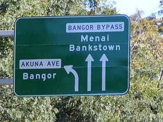
Bangor Bypass is a road in New South Wales, Australia, between New Illawarra Road and River Road, bypassing Bangor and Menai. Completed in February 2005, it replaced Menai Road as the main road between A6 and River Road, alleviating traffic on Menai Road and increasing travel speed through Bangor and Menai. It also acts as a western extension of River Road and Woronora Bridge, which was completed four years earlier in 2001. A section of New Illawarra Road north of the bypass was also completed as part of the project, linking the bypass directly to Alfords Point Road.

<span class="mw-page-title-main">Alfords Point Bridge</span> Bridge in New South Wales, Australia

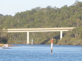
Alfords Point Bridge is a twin 445-metre-long (1,460 ft) concrete and steel box girder road bridge that carries Alford Point Road as state route A6 across the lower Georges River between Padstow Heights in the City of Canterbury-Bankstown and Alfords Point in the Sutherland Shire in Sydney, New South Wales, Australia.

<span class="mw-page-title-main">Lugarno, New South Wales</span> Suburb of Sydney, New South Wales, Australia

Lugarno is a suburb situated in the St George area of southern Sydney, in the state of New South Wales, Australia. It is located in the local government area of the Georges River Council, 23 kilometres south of the Sydney central business district.

References

  1. 1 2 Australian Bureau of Statistics (27 June 2017). "Alfords Point (State Suburb)". 2016 Census QuickStats. Retrieved 25 January 2018. OOjs UI icon edit-ltr-progressive.svg
  2. Sutherland Shire place names Archived 18 September 2006 at the Wayback Machine
  3. "History of Sutherland Shire Council: Fact Sheet 1" (PDF). Archived from the original (PDF) on 10 July 2005. Retrieved 3 August 2008.
  4. Alfords Point Public School
  5. Alfords Point Pre-School Kindergarten
  6. Sutherland Shire street name origins
  7. Steve Waugh sells Alfords Point home for $1.9 million Domain 4 July 2015

33°59′05″S151°01′17″E / 33.98480°S 151.02142°E / -33.98480; 151.02142