
Mendon is a town in Worcester County, Massachusetts, United States. The population was 6,228 at the 2020 census. Mendon is part of the Blackstone River Valley National Heritage Corridor, an early center of the industrial revolution in the United States. Mendon celebrated its 350th Anniversary on May 15, 2017.

Uxbridge is a town in Worcester County, Massachusetts first colonized in 1662 and incorporated in 1727. It was originally part of the town of Mendon, and named for the Earl of Uxbridge. The town is located 36 mi (58 km) southwest of Boston and 15 mi (24 km) south-southeast of Worcester, at the midpoint of the Blackstone Valley National Historic Park. The historical society notes that Uxbridge is the "Heart of The Blackstone Valley" and is also known as "the Cradle of the Industrial Revolution". Uxbridge was a prominent Textile center in the American Industrial Revolution. Two Quakers served as national leaders in the American anti-slavery movement. Uxbridge "weaves a tapestry of early America".

Route 146, sometimes called the Worcester-Providence Turnpike, is a limited-access road in the U.S. state of Massachusetts, maintained by the Massachusetts Department of Transportation (MassDOT). Spanning approximately 21 miles (34 km) along a south–north axis, it is a continuation of Route 146 in Rhode Island, which splits from I-95 in Providence. The southern terminus within Massachusetts exists in Millville, where the expressway enters the state from North Smithfield, Rhode Island. Among several local roads, Route 146 intersects with the Massachusetts Turnpike (I-90) in Millbury and I-290 in Worcester before arriving at its northern terminus at the intersection of several surface streets in downtown Worcester. Most of the route is a freeway, except for a short section near the boundary between Millbury and Sutton where there is driveway access and at-grade crossings.

The Blackstone Valley or Blackstone River Valley is a region of Massachusetts and Rhode Island. It was a major factor in the American Industrial Revolution. It makes up part of the Blackstone River Valley National Heritage Corridor and National Historical Park.
Lydia Taft was the first woman known to legally vote in colonial America. This occurred at a town meeting in the New England town of Uxbridge in Massachusetts Colony, on October 30, 1756.

John Willard Capron was an American military officer in the infantry, state legislator, and textile manufacturer.
Bezaleel Taft Sr. was an American Revolutionary War soldier, Captain and American legislator from Uxbridge, Massachusetts.
Luke Taft was an industrial pioneer in the manufacture of woolens in 19th century New England.

Moses Taft 2nd was born at Uxbridge, Massachusetts. He was significant as an early American Industrialist and financier in the historic Blackstone Valley, and a member of the famous Taft family.
Robert Taft Jr. (1674–1748), also known as Robert Taft II, was a Massachusetts politician. He was born in Braintree, Massachusetts Bay Colony. He died at age 74 at Uxbridge, Worcester County, Massachusetts.
Linwood is a village with its own post office in the towns of Northbridge and Uxbridge, Massachusetts.

North Uxbridge is a village and a post office in the town (township) of Uxbridge in Worcester County, Massachusetts, United States. The postal zip code is 01538. It is classified as a community or populated place located at latitude 42.088 and longitude -71.641 and the elevation is 266 feet (81 m). North Uxbridge appears on the Uxbridge U.S. Geological Survey Map. Worcester County is in the Eastern time zone and observes DST. North Uxbridge is located about 36 miles WSW of Boston, and 15 miles SE of Worcester. The town meeting in 1885 set aside North Uxbridge as a "special district", since its population had exceeded 1000 people. North Uxbridge appeared to be a separate Census tract in the 1960 census with a population of 1882. In 2013, an Uxbridge DIY show, The Garage, with Steve Butler, went worldwide from Steve's garage in North Uxbridge.

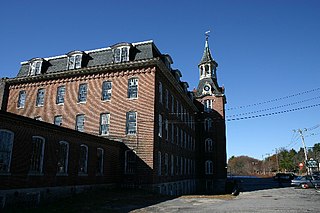
Wheelockville is a village in the town (township) of Uxbridge, Massachusetts, United States. Part of the village centering on Mendon and Henry streets is listed on the National Register of Historic Places as the Wheelockville Historic District. Wheelockville appears on the Blackstone U.S. Geological Survey Map. The Village receives municipal services from Uxbridge, for fire, police, EMS, School district, public works, and other services. Worcester's Judicial District includes Uxbridge District Court. The geography of Wheelockville includes several other distinct mill villages, including: Hecla and Elmdale.

Ironstone is an historic village,, in the township of Uxbridge, Massachusetts, United States. It derived its name from plentiful bog iron found here which helped Uxbridge to become a center for three iron forges in the town's earliest settlement. South Uxbridge has historic sites, picturesque weddings, hospitality, industrial and distribution centers, and the new Uxbridge High School. This community borders North Smithfield, and Burrillville, Rhode Island, and Millville, Massachusetts. South Uxbridge receives municipal services from Uxbridge, for fire, police, EMS, School district, public works, and other services. There is a South Uxbridge fire station of the Uxbridge fire department. Worcester's Judicial District includes Uxbridge District Court. Ironstone appears on the Blackstone U.S. Geological Survey Map. Worcester County is in the Eastern time zone and observes DST.

The Friends Meetinghouse is an historic Friends Meeting House of the Religious Society of Friends (Quakers) located at the junction of Routes 146A and 98 in Uxbridge, Massachusetts. On January 24, 1974, it was added to the National Register of Historic Places.

The Moses Farnum House is an historic house located on Route 146A. in Uxbridge, Massachusetts. On October 7, 1983, it was added to the National Register of Historic Places.

The E. Albee House is an historic house located at 217 Chapin Street, in Uxbridge, Massachusetts. Probably built in the mid-18th century, it is a well-preserved example of rural vernacular period architecture. On October 7, 1983, it was added to the National Register of Historic Places.

West Hill Dam Reserve is a United States Army Corps of Engineers flood control project with a recreational park and wildlife management area located at Uxbridge, Massachusetts. The West Hill Dam Project was completed in 1960. It is located on the West River, one of the branches of the Blackstone River which flows from Worcester, MA to Providence, RI. The West River originates in Grafton, Massachusetts, at Cider Mill Pond and Silver Lake, near Upton, Massachusetts, and the Upton State Forest. The dam is unusual in that it isn't filled unless there is a flood. West Hill Dam was built after devastating floods during the 1950s; it is intended to protect the Blackstone Valley from future destructive flooding. The cities and towns downriver from Uxbridge, including Millville, Blackstone, Woonsocket, North Smithfield, Cumberland, Lincoln, Central Falls, Pawtucket and Providence, Rhode Island, suffered extensive flooding from the Blackstone during Hurricane Diane in 1955. Hurricane Donna tested this new dam in 1960 as the eyewall passed over. The West Hill Dam is located in the Blackstone River Valley National Heritage Corridor near the Blackstone River and Canal Heritage State Park. Park rangers provide visitor assistance and offer scheduled interpretative programs. Fishing, hunting, and wildlife viewing opportunities are available year-round. The park has a recreation area, 34 picnic sites, one playground, a swimming area and five miles of hiking trails. However, access to the park from West Hill Road is currently blocked as of 2021 because of landowner disagreements. West Hill Dam is also the field office for the Charles River Natural Valley Storage Area. It consists of scattered wetlands in the upper and middle Charles River watershed, between the towns of Bellingham and Needham. The wetlands provide flood storage area, fisheries, wildlife management, and recreation. The Charles River is the well-known watercourse that flows into Boston Harbor.
The Taft family of the United States has historic origins in Massachusetts; its members have served Ohio, Massachusetts, Vermont, Rhode Island, Utah, and the United States in various positions such as U.S. Representative (two), Governor of Ohio, Governor of Rhode Island, U.S. Senator (three), U.S. Secretary of Agriculture, U.S. Attorney General, U.S. Secretary of War (two), President of the United States, and Chief Justice of the United States.
The history of Uxbridge, Massachusetts, founded in 1727, may be divided into its prehistory, its colonial history and its modern industrial history. Uxbridge is located on the Massachusetts-Rhode Island state line, and became a center of the earliest industrialized region in the United States.


