Tropical storm (39–73 mph, 63–118 km/h)
Category 1 (74–95 mph, 119–153 km/h)
Category 2 (96–110 mph, 154–177 km/h)
Category 3 (111–129 mph, 178–208 km/h)
Category 4 (130–156 mph, 209–251 km/h)
Category 5 (≥157 mph, ≥252 km/h)
Unknown
Towards the middle of February 2005, a monsoonal trough of low pressure developed near the island nation of Tuvalu and extended eastwards to the north of the Samoan Islands. [1] During February 10, this area of low pressure spawned two systems, which were classified as the eight and ninth tropical disturbances of the 2004-05 season by the Fiji Meteorological Service (FMS). [1] The first of these tropical disturbances was classified as 09F, while it was located about 330 km (205 mi) to the northeast of Apia, Samoa and later developed into Severe Tropical Cyclone Nancy. [1] The second of these disturbances was 08F which was classified as a tropical disturbance while it was located about 650 km (405 mi) to the northeast of Nadi, Fiji. [1]
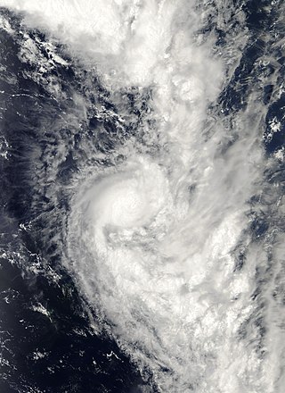
A tropical wave formed on February 10. The tropical wave, then spawned two areas of low pressure, one of which became Tropical Depression 08F. At 1300 UTC, the tropical depression was located 490 miles north west of Apia. By 1500, the depression organized into a tropical storm with 40 mph wind and was named Olaf. At the time of formation, the tropical storm was nearly stationary. The low wind shear and warm water temperatures allowed Olaf to undergo rapid intensification. In a 12‑hour period, Olaf quickly became a Category 1 cyclone with 80 mph (130 km/h) winds in a 10-minute average speed. On February 15, the barometric pressure fell to 930 mbar as Olaf reached Category 4 status. After reaching Category 4 status, Olaf then moved on a south-southeasterly course at 7 mph (11 km/h). [2]
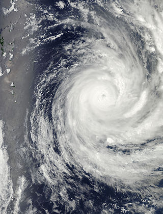
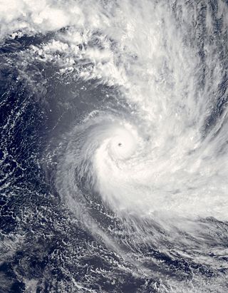
Cyclone Olaf then tuned east and moving 100 miles (160 km) east of Western Samoa. On February 16, satellite imagery depicted a well-defined eye as Olaf strengthened into a Category 5 cyclone. Olaf reached a peak intensity of 165 mph with a barometric pressure of 915 millibars. It is possible Olaf could have a lower pressure but official track reports have Olaf at 915 mbar. At the time of peak intensity, the center of the storm was only 70 miles (110 km) northeast of American Samoa and 90 miles (140 km) northwest of Pago Pago. At the same time, Cyclone Olaf underwent a minor Fujiwhara effect with Cyclone Nancy before resuming its southeasterly course. Moving at 10 mph (16 km/h), the cyclone maintained Category 5 status as the eye passed 15 miles east of Ta'u, American Samoa. During that time, a weather station reported a 931 barometric pressure reading. [2]
On February 18, an approaching upper-level trough to the south, and strong wind shear caused Olaf to weaken as the storm rapidly moved southeastward. As Olaf moved into the New Zealand area of responsibility, the main circulation separated from the center and Olaf quickly became extratropical 18 hours later. The extratropical remnants of Olaf, quickly re-intensified into a powerful extratropical storm on February 23. The extratropical storm persisted for two days before dissipating near Pitcairn Island [2]
Preparations

Forecasts predicted Olaf to move near and over Samoa and American Samoa in 24–48 hours and hitting the southern Cook Islands as a Category 4 cyclone. [3] In American Samoa, schools and businesses were closed and warnings were broadcasting over television and radio. Forecasters predicted that Olaf will bring storm surge and inland flooding and strong winds. In Niue, the cyclone was carefully monitored by forecasters, fearing a repeat of the destruction wrought by Cyclone Heta a year ago. French Polynesia was also under a cyclone warning. Forecasters further issued Watches and warnings for the rest of the Cook Islands. [4]
The next day, Olaf diverted course forcing authorities to order evacuations. In Tutuila, 70 emergency shelters were opened and 1,000 people evacuated low-lying areas. The approach of the cyclone, shut down the local airport, cancelling numerous flights. In Tau, most of the residences evacuated to storm shelters built on higher ground. The evaluation in the Manu'a group islands, totaled up to 2,000. [5]
Impact
A destructive cyclone, Olaf caused severe damage in both Samoa and American Samoa. Because of well executed warnings and evacuations, there were no deaths. However, 2 people were reported missing and assumed dead, when their boat sank during the storm.
Samoa and American Samoa

Although the eye of Olaf never made landfall, several weather stations reported sustained winds of 75–125 mph (121–201 km/h). The winds damaged powerlines and closed an airport. Olaf also produced storm surge damage along the coast. [2] Offshore, fishing fleet was caught off guard by the storm. One of the boats, sank 150 miles (240 km) off the coast of Samoa, however the crew was rescued. [6] 21 other fishermen were also rescued. [2] Olaf then brushed past the American Samoa, bringing 125 mph (201 km/h) winds. Because of Olaf strength, there was severe damage across American Samoa. In the Manua Islands, the storm destroyed several seaside homes, ruined crops and left thousands without power. In Tau, 80–90 percent of the infrastructure was destroyed by the storm. [2] Offshore, three people were rescued after their boat sank near Pago Pago. [7]
Cook Islands
Olaf then struck the Cook Islands which were already reeling form the impact of Cyclones Meena and Nancy earlier. In Rarotonga, Olaf skirted the western side of the island. That placed the island in the strongest part of the storm, which resulted in extensive damage to homes and businesses. According to press reports, nearly 30–40 percent of the population was left without electricity and 60% of the structures sustained damage. [2]
Aftermath
Olaf damaged several water stations in the Manua Islands causing a water shortage. Because of the damage, President George W. Bush declared those islands disaster areas. The declaration allowed residents and local governments in the American Samoa to receive federal aid. The Federal Emergency Management Agency provided much aid to the residents of the American Samoa. [8] The Initial Response Resources were sent to the American Samoa and its surrounding islands and was distributed by the United States Coast Guard and the government of the American Samoa on February 21, 2005. [9] Despite the devastation in the Manua Islands, it could have been worse if Olaf hit American Samoa directly. [2] In the Cook Islands, the Australian and New Zealand governments provided over A$30,000 (2005) in relief assistance. [10] On February 22, 2005, the Government of New Zealand, provided materials and workmen to help with the cleanup effort. The French government and the United Nations also assisted in the relief effort by sending soldiers from Tahiti and providing more aid to the stricken residents. [11]
Because of the extensive damage in Samoa and the Cook Islands, Olaf was retired in May of 2006, and was replaced with Osai.
See also
Related Research Articles

Severe Tropical Cyclone Heta was a Category 5 tropical cyclone that caused moderate damage to the islands of Tonga, Niue, and American Samoa during late December 2003 and early January 2004. Heta formed on December 25, 2003; it reached a maximum intensity of 260 km/h (160 mph) and an estimated pressure of 915 hPa before dissipating on January 11, 2004. It was the first named tropical cyclone to form during the 2003–04 South Pacific cyclone season.

Severe Tropical Cyclone Percy was an extremely powerful tropical cyclone, which was the third and last Category 5 cyclone to form in the 2004–05 South Pacific cyclone season. The seventh named storm and the fourth and final severe tropical cyclone to form during the 2004–05 South Pacific cyclone season. Percy originated as a tropical disturbance on February 23. Over next few days, the system organized while moving east southeastward, before intensifying into a Category 1 tropical cyclone on the Australian region scale on February 26. The system quickly intensified, reaching Category 4 status later that day. On the next day, Percy was steered southward by a blocking ridge of high pressure, while stretched out the structure of the storm into an elliptical shape, weakening it back to Category 3 status. Afterward, the storm rapidly reintensified, reaching its peak intensity as a Category 5 tropical cyclone on March 2. Afterward, Percy encountered increasing wind shear and weakened once again, turning southeastward on the next day. On March 5, Percy transitioned into an extratropical storm, before dissipating soon afterward.

The 2005–06 South Pacific cyclone season was an event in the annual cycle of tropical cyclone formation. It began on November 1, 2005, and ended on April 30, 2006. These dates conventionally delimit the period of each year when most tropical cyclones form in the southern Pacific Ocean east of 160°E. Additionally, the regional tropical cyclone operational plan defines a tropical cyclone year separately from a tropical cyclone season, and the "tropical cyclone year" runs from July 1, 2005, to June 30, 2006.

The 2004–05 South Pacific cyclone season was an above-average season in which tropical cyclones formed within the South Pacific Ocean to the east of 160°E. The season officially ran from November 1, 2004 to April 30, 2005, however a tropical cyclone could form at any time between July 1, 2004 and June 30, 2005 and would count towards the season total. The season got off to an early start, when Tropical Depression 01F developed near the Solomon Islands on October 28, three days before the official start of the season. The final disturbance of the season dissipated as the season was drawing to a close on May 1. The season was above-average in terms of activity, with 9 tropical cyclones and 5 severe tropical cyclones forming during the season. The season featured Cyclone Percy, the most intense of the season in terms of pressure.

The 2002–03 South Pacific cyclone season was the most active and longest tropical cyclone season since 1997–98, with ten tropical cyclones occurring within the South Pacific basin between 160°E and 120°W. The season started earlier than normal, with two systems developing before the official start of the season on November 1, 2002, while the final system dissipated on June 9, 2003, after the season had officially ended on April 30. During the season, tropical cyclones were officially monitored by the Regional Specialized Meteorological Centre (RSMC) in Nadi, Fiji and the Tropical Cyclone Warning Centres in Brisbane, Australia and Wellington, New Zealand. The United States Armed Forces through the Joint Typhoon Warning Center (JTWC), also monitored the basin and issued unofficial warnings for American interests. RSMC Nadi attaches a number and an F suffix to tropical disturbances that occur within the basin, while the JTWC designates significant tropical cyclones with a number and a P suffix. RSMC Nadi, TCWC Wellington and TCWC Brisbane all use the Australian Tropical Cyclone Intensity Scale and estimate windspeeds over a ten-minute period, while the JTWC estimates sustained winds over a one-minute period, which are subsequently compared to the Saffir–Simpson Hurricane Scale (SSHS).
Tropical Cyclone Urmil was a short lived storm of January 2006 that explosively intensified to reach its peak intensity as a high-end Category 2 cyclone on the Australian Scale, just 12 hours after being named. Forming out of a tropical disturbance early on January 14, Urmil quickly intensified before weakening just as quickly. The intensification was a result of the main convective banding feature wrapping around the center of circulation. However, the combination of high wind shear and the rapid movement of the cyclone caused convection to become separated from the center. By January 15, the storm transitioned into an extratropical cyclone shortly before dissipating. Urmil had only minor effects on land; scattered vegetation damage was reported in Tonga.

The 2009–10 South Pacific cyclone season began on December 3, 2009 with the formation of Tropical Disturbance 01F, 32 days after the cyclone season had officially begun on November 1, 2009. The season ended on April 30, 2010. These dates conventionally delimit the period of each year when most tropical cyclones form in the southern Pacific Ocean east of 160°E. Additionally, the regional tropical cyclone operational plan defines a tropical cyclone year separately from a tropical cyclone season; the "tropical cyclone year" began on July 1, 2009 and ended on June 30, 2010. Tropical cyclones between 160°E and 120°W and north of 25°S are monitored by the Fiji Meteorological Service. Those that move south of 25°S are monitored by the Tropical Cyclone Warning Centre in Wellington, New Zealand. The first tropical disturbance of the season formed on December 3, about 1015 km (700 mi) to the north of Suva, Fiji and later intensified into Tropical Cyclone Mick. The last system, 15F, dissipated on April 5 of the following year.

Severe Tropical Cyclone Nancy was the second in a series of four severe tropical cyclones to impact the Cook Islands during February 2005. Forming out of an area of low pressure on February 10, Nancy quickly organized into a small, but intense, cyclone. By February 14, the storm explosively intensified into a Category 4 severe tropical cyclone with winds peaking at 175 km/h (109 mph) 10-minute winds) and a minimum barometric pressure of 935 hPa (mbar). Over the following day, increasing wind shear rapidly weakened the cyclone and by February 17, it transitioned into an extratropical cyclone shortly before being absorbed by Cyclone Olaf.

Tropical Cyclone Cilla was a tropical cyclone that brought minor damage to several islands in the South Pacific in January 2003. The fifth cyclone of the 2002–03 South Pacific cyclone season, Cyclone Cilla developed from a monsoon trough on January 26 northwest of Fiji. Initially, Cilla moved east, and due to decreased wind shear, Cilla was able to intensify. On January 28, Cilla reached its peak intensity of 75 km/h (45 mph). After slightly weakening, Cilla briefly re-intensified the next day. However, Cilla transitioned into an extratropical cyclone on January 30. Along its path, Cilla dropped heavy rainfall over islands it passed. During its formative stages, the low dropped heavy rain over Fiji, which had already been affected by Cyclone Ami two weeks prior. Damage in Tonga was mostly limited to vegetation and fruit trees; infrastructural damage was also relatively minor. Cilla also brought moderate rain to American Samoa.

The 1989–90 South Pacific cyclone season was a below-average season with only five tropical cyclones occurring within the South Pacific to the east of 160°E. The season officially ran from November 1, 1989, to April 30, 1990, with the first disturbance of the season forming on November 8 and the last disturbance dissipating on March 19. This is the period of the year when most tropical cyclones form within the South Pacific Ocean.

Severe Tropical Cyclone Wilma was a powerful tropical cyclone that affected the Samoan Islands, Tonga and New Zealand. Forming out of a trough of low pressure on 19 January 2011 to the northwest of Fiji, Cyclone Wilma initially tracked eastward towards the Samoan Islands. On 22 January, the system took a sharp southward turn, bringing its centre directly over American Samoa the following day. After turning towards the southwest and accelerating, Wilma steadily intensified into a severe tropical cyclone before striking Tonga. The storm reached its peak intensity on 26 January as a Category 4 cyclone with winds of 185 km/h (115 mph) and a barometric pressure of 930 mbar. Gradually re-curving towards the southeast, Wilma weakened quickly as it moved over cooler sea surface temperatures; by 28 January, it was downgraded to a tropical cyclone. Later that day, the storm brushed the North Island of New Zealand before transitioning into an extratropical cyclone.

The 1994–95 South Pacific cyclone season was one of the least active South Pacific tropical cyclone seasons on record, with only four tropical cyclones officially occurring within the South Pacific Ocean basin between 160°E and 120°W. The season ran from November 1, 1994, until April 30, 1995, with the first disturbance of the season developing on November 12 and the last disturbance leaving the base on March 5. The most intense tropical cyclone during the season was Tropical Cyclone Violet, which briefly existed within the basin. After the season, the name William was retired from the tropical cyclone naming lists.
Severe Tropical Cyclone Evan was considered to be the worst tropical cyclone to affect the island nation of Samoa since Cyclone Val in 1991 and was the strongest storm to impact the main South Pacific islands until Winston in 2016. The system was first noted on December 9, 2012, as a weak tropical depression about 700 km (435 mi) to the northeast of Suva, Fiji. Over the next couple of days, the depression gradually developed further before it was named Evan on December 12, as it had fully developed into a tropical cyclone. During that day the system moved toward the Samoan Islands and gradually intensified, before the system slowed and severely affected the Samoan Islands during the next day with wind gusts of up to 210 km/h (130 mph).

The 2016–17 South Pacific cyclone season was the least active South Pacific cyclone season since the 2011–12 season, with only four tropical cyclones occurring within the South Pacific Ocean to the east of 160°E. Two of the four systems developed into severe tropical cyclones on the Australian tropical cyclone intensity scale. The season officially ran from November 1, 2016 until April 30, 2017. However, May featured two post-season systems: Donna and Ella, of which the former was the strongest post-season South Pacific tropical cyclone ever recorded in that month. Overall, 22 tropical disturbances were monitored by a combination of the Fiji Meteorological Service (FMS), Australian Bureau of Meteorology (BoM) and New Zealand's MetService.

The 2019–20 South Pacific cyclone season was a slightly above-average season in which tropical cyclones formed within the South Pacific Ocean to the east of 160°E. The season officially ran from November 1, 2019, to April 30, 2020, however a tropical cyclone could form at any time between July 1, 2019, and June 30, 2020, and would count towards the season total. The season began on November 22 with the formation of Tropical Cyclone Rita, which would later become a severe tropical cyclone. The season has been near-average in terms of activity, with 8 tropical cyclones and 4 severe tropical cyclones forming during the season. The season featured Cyclone Harold, the first Category 5 severe tropical cyclone in the basin since Cyclone Gita, and one of the strongest since Cyclone Winston. During the season, tropical cyclones are officially monitored by the Fiji Meteorological Service (FMS), Australian Bureau of Meteorology (BOM) and New Zealand's MetService. The United States Armed Forces through the Joint Typhoon Warning Center (JTWC) also monitors the basin and issue unofficial warnings for American interests. The FMS attaches a number and an F suffix to tropical disturbances that form in or move into the basin while the JTWC designates significant tropical cyclones with a number and a P suffix. The FMS, BoM and MetService all use the Australian Tropical Cyclone Intensity Scale and estimate wind speeds over a period of ten minutes, while the JTWC estimated sustained winds over a 1-minute period, which are subsequently compared to the Saffir–Simpson hurricane wind scale (SSHWS).
The 2020–21 South Pacific cyclone season was an average season where most tropical cyclones formed within the South Pacific Ocean to the east of 160°E. The season officially started on November 1, 2020, and officially ended on April 30, 2021, however a tropical cyclone could form at any time between July 1, 2020, and June 30, 2021, and would count towards the season total. During the season, tropical cyclones will be officially monitored by the Fiji Meteorological Service (FMS), Australian Bureau of Meteorology (BoM), New Zealand's MetService. The United States Armed Forces through the Joint Typhoon Warning Center (JTWC) will also monitor the basin and issue unofficial warnings for American interests. RSMC Nadi attaches a number and an F suffix to tropical disturbances that form in or move into the basin while the JTWC designates significant tropical cyclones with a number and a P suffix. RSMC Nadi, TCWC Wellington and TCWC Brisbane all use the Australian Tropical Cyclone Intensity Scale and estimate windspeeds over a period of ten minutes, while the JTWC estimated sustained winds over a 1-minute period, which are subsequently compared to the Saffir–Simpson hurricane wind scale (SSHWS).

Severe Tropical Cyclone Tusi was a tropical cyclone which affected the island nations of Tuvalu, Tokelau, Western Samoa, American Samoa, Niue and the Southern Cook Islands during January 1987. The precursor tropical depression to Cyclone Tusi developed on January 13, within a trough of low pressure near the island nation of Tuvalu. Over the next few days the system gradually developed further before it was named Tusi during January 16, after it had become equivalent to a modern-day category 1 tropical cyclone on the Australian tropical cyclone intensity scale. After being named the system gradually intensified as it moved southeastwards along the trough, between the islands of Fakaofo and Swains during January 17. Tusi's eye subsequently passed near or over American Samoa's Manu'a Islands early the next day, as the system peaked in intensity with 10-minute sustained wind speeds of 150 km/h (90 mph). The system subsequently posed a threat to the Southern Cook Islands, however this threat gradually diminished as Tusi moved southwards and approached 25S during January 20.
Severe Tropical Cyclone Meena was the first of four tropical cyclones to impact the Cook Islands during February 2005. The system was first identified within a trough of low pressure, about 620 km (385 mi) to the northwest of Pago Pago in American Samoa.

Severe Tropical Cyclone Amos was a strong tropical cyclone that affected the Fijian and Samoan Islands as well as Wallis and Futuna. Amos was first noted as Tropical Disturbance 17F during April 13, 2016 to the northwest of Fiji. The system subsequently moved south-eastwards towards the Fijian Islands, before it passed near or over Vanua Levu during April 16. After passing over Fiji, the system gradually developed further as it moved north-eastwards towards the Samoan Islands. The system was subsequently named Amos during April 20, after it had developed into a tropical cyclone and started to move north-westwards towards the island nation of Tuvalu.

Severe Tropical Cyclone Tino was a tropical cyclone which itself and an associated convergence zone caused significant damage across ten island nations in the South Pacific Ocean during January 2020. First noted as a tropical disturbance during January 11, to the southwest of Honiara in the Solomon Islands, the system gradually developed over the next few days as it moved eastwards in between the Solomon Islands and Vanuatu prior to being named Tino as it approached Fiji during January 16. Continuing to track south-eastward, Tino continued strengthening as it passed near Fiji, bringing copious amounts of rainfall to the area. Whilst losing latitude, the system continued to strengthen and peaked as a category 3 tropical cyclone on January 17, with signs of an eye forming. Shortly after peak intensity, Tino was impacted by high wind shear and decreasing sea surface temperatures, triggering a weakening trend. Tino moved out of the tropics shortly thereafter and became an extratropical cyclone during January 19.
References
- 1 2 3 4 Tropical Cyclo.ne Summary 2004 – 2005 Season (PDF) (Report). Fiji Meteorological Service. Archived from the original (PDF) on February 25, 2009. Retrieved December 29, 2020.
- 1 2 3 4 5 6 7 8 Olaf Report
- ↑ AFAP Warning 1 Archived 2006-02-15 at the Wayback Machine
- ↑ AFAP Warning 2 Archived 2006-02-15 at the Wayback Machine
- ↑ AFAP Warning 3 Archived 2006-02-15 at the Wayback Machine
- ↑ "Cyclone Olaf slams into Samoa". The Sydney Morning Herald . 2005-02-17. Archived from the original on 2013-02-17.
- ↑ nbcnews.com
- ↑ FEMA Disaster Declaration Archived 2007-09-11 at the Wayback Machine
- ↑ DOI report on the Olaf Archived 2007-04-04 at the Wayback Machine
- ↑ Cyclone Olaf Update February 28, 2005
- ↑ "Cinews report on Olaf". Archived from the original on 2007-10-08. Retrieved 2007-04-30.
External links
 Cyclone Olaf near peak intensity on February 16 |
Tropical cyclones of the 2004–05 South Pacific cyclone season | ||
|---|---|---|
 | ||
| Pre-2000s | |
|---|---|
| 2000s | |
| 2010s | |
| 2020s | |
| Other systems | |
| 1970s | |
|---|---|
| 1980s | |
| 1990s | |
| 2000s | |
| 2010s | |
| 2020s | |