Cyclone Thelma

Last updated

Map key
  Tropical depression (≤38 mph, ≤62 km/h)
  Tropical storm (39–73 mph, 63–118 km/h)
  Category 1 (74–95 mph, 119–153 km/h)
  Category 2 (96–110 mph, 154–177 km/h)
  Category 3 (111–129 mph, 178–208 km/h)
  Category 4 (130–156 mph, 209–251 km/h)
  Category 5 (≥157 mph, ≥252 km/h)
  Unknown
Storm type
Disc Plain black.svg Tropical cyclone
Solid black.svg Subtropical cyclone
ArrowUp.svg Extratropical cyclone, remnant low, tropical disturbance, or monsoon depression

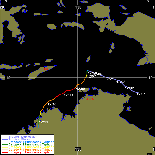
A developing low in the Timor Sea in early December was named Thelma at 2 p.m. Australian Central Standard Time (0430 UTC) on 6 December, located about 350 km (220 mi) north of Darwin. The new cyclone drifted slowly south while rapidly intensifying. Thelma's intensity increased from a Category 2 to a Category 4 during 7 December. Thelma turned towards the southwest and reached Category 5 intensity on the Australian scale just north of Bathurst Island at about 9 a.m. CST on 8 December (2330 UTC 7 December). The cyclone attained a minimum central pressure of 920 hPa, and maximum wind gusts of 320 km/h (200 mph) at 8 p.m. CST (1030 UTC) on the 8 December, only two days after being named. Cyclone Thelma's rate of intensification was close to twice the average rate of most cyclones. [4] [5]

Thelma continued moving steadily southwest at about 10 km/h (6.2 mph) before turning southwards, passing about 50 km (31 mi) from Troughton Island. The cyclone weakened to a Category 3 while crossing the Kimberley coast northwest of Kuri Bay early on 11 December. The cyclone weakened rapidly while over land. Thelma was downgraded below cyclone strength late on 11 December while moving in a more southerly track. The ex-cyclone moved through the west Kimberley and Pilbara on 12 December and 13 December. On the morning of 14 December, the low crossed the Pilbara coast north of Wallal, 240 km (150 mi) east northeast of Port Hedland. It then moved southward through Pilbara and dissipated. [4] [5]

Preparations

All residents of major communities, including Darwin, and offshore installations directly affected by the cyclone were either evacuated or were sheltered in secure accommodation. The port of Darwin was closed during the cyclone, schools were closed for one day and public cyclone shelters were opened on the night of 8 December for people who felt insecure in their place of residence. [6] Emergency officials evacuated about 120 people in the tiny community of Kalumburu, but about 180 people were left behind. Most of those sheltered in an old monastery which had 60 cm (24 in) thick stone walls. [2]

Impact

Overall, the damage caused by Cyclone Thelma was relatively light, compared with the cyclone's severe intensity. However, Thelma still had a significant impact on people's activities near the Tiwi Islands and the Kimberley coast.

In the Tiwi Islands, the most significant impact was disruption to communications and power supplies. The telephone service throughout the Tiwi Islands was shut down for over 24 hours. The radio and television reception was interrupted by heavy rain and lightning, and the power supply in Pirlangimpi (Garden Point) was cut by fallen trees. Around Bathurst Island and northwest Melville Island, there was extensive damage to vegetation in exposed areas. Minor coastal erosion occurred in Milikapiti, where waves rose up to 4 metres (13 feet) above water level. In Pirlangimpi, many large trees were uprooted and several houses were slightly damaged. In Nguiu, Bathurst Island Township, some trees were blown down but there was no significant damage. [6]

In Darwin, there was minor damage to houses and minor disruption to power supplies, caused by falling trees. A record 425 mm (16.7 in) of rain was recorded within 24 hours at Howard Springs, and a 48-hour total of 432 mm (17.0 in) was recorded at Darwin Airport from 8 December to 10 December. The rain caused local flooding in the rural areas around Darwin, blocking off some areas. [6]

In the Kimberley region, there was minor damage to some buildings at Kalumburu and water level in the river rose to within 50 metres (160 feet) of the town. The BHP facilities at Troughton Island were affected by very destructive winds and heavy rainfall from the cyclone's core, damaging the runway and buildings. Average wind speeds of 139 km/h (86 mph) and a maximum gust of 174 km/h (108 mph) were recorded before communications were lost. Only minor damage was received at the pearling facilities at Vansittart Bay and Kuri Bay, mainly to floating pontoons. [6] A number of places reported daily rainfall totals in excess of 100 mm (3.9 in) including 223 mm (8.8 in) in Kalumburu on 11 December, and 174 mm (6.9 in) in Ellendake on 13 December. McGowan Island, to the north of Kalumburu received 490 mm (19 in) of rain between 9 December and 13 December. Parts of east Pilbara also reported heavy rains over several days. Marble Bar recorded 239 mm (9.4 in) and Newman recorded 175 mm (6.9 in) in a two-day period. [5]

Retirement

The name Thelma was removed from the official list of tropical cyclone names set out by the Tropical Cyclone Warning Centre in Darwin. [7] It was replaced with the name Tasha. [8]

See also

Related Research Articles

<span class="mw-page-title-main">Cyclone Ingrid</span> 2005 Australian region cyclone

Severe Tropical Cyclone Ingrid was a powerful tropical cyclone which struck northern Australia during the 2004–05 Australian region cyclone season. Its minimum pressure was 924 mbar (hPa).

<span class="mw-page-title-main">Cyclone Steve</span> Category 3 Australian region cyclone in 2000

Tropical Cyclone Steve was a tropical cyclone that affected northern Australia from 27 February 2000 until 11 March 2000. Cyclone Steve was noted for its longevity and traversal of northern and western Australia. It impacted on regions of northern Queensland, the Northern Territory and Western Australia before clearing to the south of the continent. Steve is the first known Australian cyclone to make four distinct landfalls in the country.

<span class="mw-page-title-main">Cyclone Vance</span> Category 5 Australian region cyclone in 2003

Severe Tropical Cyclone Vance was a tropical cyclone that struck Western Australia during the active 1998–99 Australian region cyclone season, and was also one of six tropical cyclones to form off the coast of Australia during that season. When making landfall the Learmonth Meteorological Office recorded the highest Australian wind gust of 267 km/h (166 mph). The previous highest gust was 259 km/h (161 mph) at nearby Mardie during Cyclone Trixie. This record was surpassed in 2010 after a world record wind-gust of 408 km/h (254 mph) at Barrow Island during Cyclone Olivia in 1996 was declared official by the World Meteorological Organisation.

<span class="mw-page-title-main">1999–2000 Australian region cyclone season</span>

The 1999–2000 Australian region cyclone season was a slightly above average tropical cyclone season. It ran from 1 November 1999 to 30 April 2000. The regional tropical cyclone operational plan also defines a "tropical cyclone year" separately from a "tropical cyclone season", with the "tropical cyclone year" for this season lasting from 1 July 1999 to 30 June 2000.

<span class="mw-page-title-main">2004–05 Australian region cyclone season</span> Tropical cyclone season

The 2004–05 Australian region cyclone season was a slightly below average tropical cyclone season. It began on 1 November 2004 and ended on 30 April 2005. The regional tropical cyclone operational plan also defines a tropical cyclone year separately from a tropical cyclone season, which runs from 1 July 2004 to 30 June 2005.

<span class="mw-page-title-main">1996–97 Australian region cyclone season</span>

The 1996–97 Australian region cyclone season was an above average tropical cyclone season. It ran from 1 November 1996 to 30 April 1997. The regional tropical cyclone operational plan also defines a tropical cyclone year separately from a tropical cyclone season, and the "tropical cyclone year" ran from 1 July 1996 to 30 June 1997.

<span class="mw-page-title-main">1995–96 Australian region cyclone season</span>

The 1995–96 Australian region cyclone season was an active Australian cyclone season, with Western Australia experiencing a record number of landfalling intense storms in the Pilbara region. The season produced a total of 19 tropical cyclones, of which 14 developed into named storms and 9 reached severe tropical cyclone status. The strongest of the season was Severe Tropical Cyclone Olivia, which also produced the highest recorded wind gust on record of 408 km/h (253 mph). Though several systems impacted land, the general sparsity of population centres in Australia limits the scale of damage. One person was confirmed to have been killed and cumulative losses were estimated at A$77 million (US$58.5 million).

<span class="mw-page-title-main">2009–10 Australian region cyclone season</span> Tropical cyclone season

The 2009–10 Australian region cyclone season was a below average tropical cyclone season, with eight tropical cyclones forming compared to an average of 12. The season began on 1 November 2009 and ran through until it end on 30 April 2010. The Australian region is defined as being to south of the equator, between the 90th meridian east and 160th meridian east. Tropical cyclones in this area are monitored by five Tropical Cyclone Warning Centres (TCWC's): Jakarta, Port Moresby, Perth, Darwin, and Brisbane, each of which have the power to name a tropical cyclone. The TCWC's in Perth, Darwin, and Brisbane are run by the Australian Bureau of Meteorology, who designate significant tropical lows with a number and the U suffix. The Joint Typhoon Warning Center also issues unofficial warnings for the region, designating significant tropical cyclones with the "S" suffix when they form west of 135°E, and the "P" suffix when they form east of 135°E.

<span class="mw-page-title-main">2010–11 Australian region cyclone season</span> Tropical cyclone season

The 2010–11 Australian region cyclone season was a near average tropical cyclone season, with eleven tropical cyclones forming compared to an average of 12. The season was also the costliest recorded in the Australian region basin, with a total of $3.62 billion in damages, mostly from the destructive Cyclone Yasi. The season began on 1 November 2010 and ended on 30 April 2011, although the first tropical cyclone formed on 28 October. The Australian region is defined as being to the south of the equator, between the 90th meridian east and 160th meridian east. Tropical cyclones in this area are monitored by five Tropical Cyclone Warning Centres (TCWC's): Jakarta, Port Moresby, Perth, Darwin, and Brisbane, each of which have the power to name a tropical cyclone. The TCWC's in Perth, Darwin, and Brisbane are run by the Bureau of Meteorology, who designate significant tropical lows with a number and the U suffix. The Joint Typhoon Warning Center also issues unofficial warnings for the region, designating significant tropical cyclones with the "S" suffix when they form west of 135°E, and the "P" suffix when they form east of 135°E.

<span class="mw-page-title-main">Cyclone Laurence</span>

Severe Tropical Cyclone Laurence of December 2009 was the first Category 5 tropical cyclone to make landfall in Australia since Cyclone George in 2007.

<span class="mw-page-title-main">Cyclone Clare</span> Category 3 Australian region cyclone in 2006

Severe Tropical Cyclone Clare was a moderately strong cyclone that struck Western Australia in January 2006. The storm formed as an area of low pressure in the Arafura Sea, and moved westward. After receiving the name Clare on 7 January, the system ultimately peaked at Category 3 intensity on the Australian tropical cyclone scale. It moved ashore on the coast of Pilbara and proceeded inland, dissipating on 10 January. Clare produced winds of 142 km/h (88 mph) at Karratha and triggered widespread torrential rainfall that led to flooding. Following its usage, the name Clare was retired by the Bureau of Meteorology, and will never be used again for a tropical cyclone in the area.

<span class="mw-page-title-main">Cyclone Fay</span> Category 5 Australian region cyclone in 2004

Severe Tropical Cyclone Fay was an intense late-season tropical cyclone which struck Western Australia during the 2003–04 Australian region cyclone season. Forming from an area of low pressure on 12 March, Fay was the only Category 5 cyclone during the season. The system had a minimum pressure of 910 mbar and maximum sustained winds of 210 km/h (130 mph). Moving towards the southwest and eventually towards the south, Fay gradually strengthened as it paralleled the northwestern coast of Australia, and made landfall on the Pilbara coast on the morning of 27 March as a Category 4 cyclone.

<span class="mw-page-title-main">2016–17 Australian region cyclone season</span> Tropical cyclone season

The 2016–17 Australian region cyclone season, despite a very high number of tropical lows, was a slightly below-average season in terms of activity, with nine tropical cyclones, three of which intensified further into severe tropical cyclones; though it was much more active than the previous season. The season was the first to have a severe tropical cyclone since the 2014–15 season. It was the period of the year when most tropical cyclones form in the Southern Indian Ocean and Pacific Oceans between 90°E and 160°E. The season officially ran from 1 November 2016 to 30 April 2017, however, a tropical cyclone could form at any time between 1 July 2016 and 30 June 2017 and would count towards the season total. The first named storm, Yvette, developed during 21 December, and the final named storm, Greg, left the region on 3 May as a remnant low. This season was also the second-costliest tropical cyclone season on record in the Australian region basin, behind only the 2010–11 season, with a total of AUD$3.7 billion in damages incurred by the various storms, mostly from Cyclone Debbie.

<span class="mw-page-title-main">1991–92 Australian region cyclone season</span>

The 1991–92 Australian region cyclone season saw several intense storms. It was also an event in the ongoing cycle of tropical cyclone formation. It ran from 1 November 1991 to 30 April 1992. The regional tropical cyclone operational plan also defines a tropical cyclone year separately from a tropical cyclone season, and the "tropical cyclone year" ran from 1 July 1991 to 30 June 1992.

<span class="mw-page-title-main">Cyclone Monty</span>

Severe Tropical Cyclone Monty was a powerful category 4 tropical cyclone that formed during late February 2004. Monty was the 6th tropical cyclone and the 3rd Severe tropical cyclone of the 2003-04 Australian region cyclone season. Monty made landfall in a large, sparsely populated region of the Pilbara, Western Australia. Due to the low population, damages inland were not high, although there was major flooding and many roads were impassable because they were flooded or washed away by water. Monty set record high amounts of flooding in some parts of Western Australia.

<span class="mw-page-title-main">Cyclone Ilona</span> Category 2 Australian region cyclone

Severe Tropical Cyclone Ilona caused moderate damage across the Pilbara region of Western Australia in mid-December 1988. The system originated from a monsoon trough that coalesced into a tropical low over the Timor Sea on 12 December. The system initially moved southwest, before moving on a more westerly course. Steady intensification occurred and Ilona reached its peak strength on 17 December as a low-end severe tropical cyclone. A southward turn directed the cyclone toward Western Australia, and it made landfall near Mardie Station. The system subsequently degraded over land and dissipated on 19 December.

<span class="mw-page-title-main">Cyclone Kelvin</span> Category 3 Australia cyclone in 2018

Severe Tropical Cyclone Kelvin was a strong tropical cyclone that impacted Western Australia in February 2018, causing moderate damage. The system was first identified as a weak tropical low on the morning of 11 February over the Northern Territory's Tiwi Islands by the Australian Bureau of Meteorology (BoM). The low moved southwestwards over land and emerged over the Indian Ocean near Broome on 16 February. The storm intensified into a Category 1 tropical cyclone on the following day, becoming the sixth named storm of the 2017–18 Australian region cyclone season. Kelvin subsequently moved slowly eastwards and began to rapidly intensify in the hours prior to landfall. On 18 February, the storm crossed the coast along Eighty Mile Beach as a Category 3 severe tropical cyclone on the Australian scale, and a high-end Category 1 hurricane-equivalent cyclone on the Saffir–Simpson scale. Despite being over land, Kelvin weakened at a slow rate over the next few days, and was downgraded to a tropical low on 19 February. The remnant low of the system drifted over the Outback before being last noted by BoM on 21 February.

<span class="mw-page-title-main">Cyclone Heidi</span> Tropical cyclone in 2012

Severe Tropical Cyclone Heidi was a small and moderately-powerful tropical cyclone that struck Western Australia in January 2012. The seventh tropical low, third tropical cyclone, and second severe tropical cyclone of the 2011–12 Australian region cyclone season, Heidi developed from a tropical low that formed to the south of Indonesia on 9 January, before strengthening into a Category 1 tropical cyclone on the following day. Tracking southward towards the Pilbara coast in a favourable environment, Heidi rapidly intensified and attained Category 3 severe tropical cyclone status on 11 January. After making landfall at peak intensity later that day with estimated winds of 150 km/h (95 mph), Heidi rapidly weakened, dissipating over Western Australia by 13 January.

<span class="mw-page-title-main">Cyclone Damien</span> Category 2 Cyclone in 2020

Severe Tropical Cyclone Damien was the strongest cyclone to make landfall in the Western Australian coast since Cyclone Christine in 2013 and the second-strongest cyclone in the 2019–20 Australian region cyclone season after Cyclone Ferdinand. The fifth tropical low, and the third named storm of the 2019–20 Australian region cyclone season, Damien originated from a monsoon trough over Kimberley.

<span class="mw-page-title-main">Cyclone Carlos</span>

Severe Tropical Cyclone Carlos was a strong tropical cyclone that made landfall in Australia and resulted in $12.3 million USD in damages. Carlos was first spotted on February 14 near Batchelor and it intensified to a Category 3 cyclone on February 22. The storm affected Australia for most of its life.

References

  1. Bureau of Meteorology. "Bureau - Severe Tropical Cyclone Thelma". Bureau of Meteorology. Retrieved 1 August 2006.
  2. 1 2 Gary Padgett (1999). "MONTHLY GLOBAL TROPICAL CYCLONE SUMMARY - DECEMBER, 1998". Archived from the original on 16 March 2006. Retrieved 1 August 2006.
  3. Camden Smith (11 October 1999). "Cyclone: Skull found in bush". Northern Territory News.
  4. 1 2 Bureau of Meteorology. "Track of 'Thelma'". Bureau of Meteorology. Retrieved 1 August 2006.
  5. 1 2 3 Bureau of Meteorology. "Bom - SIGNIFICANT WEATHER - DECEMBER 1998". Bureau of Meteorology. Retrieved 1 August 2006.
  6. 1 2 3 4 Bureau of Meteorology. "Damage from 'Thelma'". Bureau of Meteorology. Retrieved 1 August 2006.
  7. Hurricane Alley (2005). "Retired Tropical Cyclone Names". Hurricane Alley Inc. Archived from the original on 19 June 2006. Retrieved 26 August 2006.
  8. Bureau of Meteorology (2005). "TROPICAL CYCLONE NAMES". Bureau of Meteorology. Archived from the original on 15 June 2006. Retrieved 16 June 2006.
Severe Tropical Cyclone Thelma
Thelma 1998-12-10 0502Z.png
Cyclone Thelma near peak intensity