The 1999–2000 Australian region cyclone season was a slightly above average tropical cyclone season. It ran from 1 November 1999 to 30 April 2000. The regional tropical cyclone operational plan also defines a "tropical cyclone year" separately from a "tropical cyclone season", with the "tropical cyclone year" for this season lasting from 1 July 1999 to 30 June 2000.

The 2007–08 Australian region cyclone season was a slightly below-average tropical cyclone season. The season began with an early start, with the formation of the first tropical cyclone on 29 July, which was only recognized as a tropical cyclone during post-season analysis. This was the second time that a tropical cyclone had formed during July. The other one was Cyclone Lindsay in the 1996–1997 season. The next tropical cyclone that formed was Cyclone Guba, which formed on 13 November with TCWC Port Moresby assigning the name Guba on 14 November, which was the first named storm within TCWC Port Moresby's area of responsibility since Cyclone Epi in June 2003. Guba was also the first cyclone to occur in the Queensland region in November since 1977.

The 2006–07 Australian region cyclone season was a below average tropical cyclone season. It began on 1 November 2006 and ended on 30 April 2007; however, Tropical Cyclone Pierre formed on 17 May, after the official end date. The regional tropical cyclone operational plan also defines a tropical cyclone year separately from a tropical cyclone season, which runs from 1 July 2006 to 30 June 2007.

The 2005–06 Australian region cyclone season was an above average tropical cyclone season. It began on 1 November 2005 and ended on 30 April 2006. The regional tropical cyclone operational plan also defines a tropical cyclone year separately from a tropical cyclone season, which runs from 1 July 2005 to 30 June 2006.

The 2003–04 Australian region cyclone season was a slightly below average tropical cyclone season. It began on 1 November 2003 and ended on 30 April 2004. The regional tropical cyclone operational plan also defines a tropical cyclone year separately from a tropical cyclone season, which runs from 1 July 2003 to 30 June 2004.

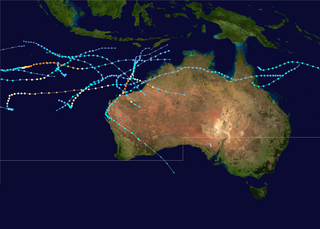
The 2002–03 Australian region cyclone season included Cyclone Inigo, which tied with Cyclone Gwenda in 1999 as the most intense tropical cyclone on record in the Australian basin. It began on 1 November 2002 and ended on 30 April 2003. The regional tropical cyclone operational plan also defines a tropical cyclone year separately from a tropical cyclone season, which runs from 1 July 2002 to 30 June 2003. These dates conventionally delimit the period of each year when most tropical cyclones form in the Australian region, which is defined as in the southern hemisphere between 90°E and 180°E. The season's ten tropical depressions existed within these dates, with the first, designated as Tropical Cyclone 07S, entering the basin on 27 December 2002. The last system, Cyclone Epi, dissipated on 6 June 2003. Tropical cyclones in this area were monitored by four Tropical Cyclone Warning Centres (TCWCs): the Australian Bureau of Meteorology (BOM) in Perth, Darwin, and Brisbane and one in Port Moresby, Papua New Guinea.

The 2001–02 Australian region cyclone season was a slightly below average tropical cyclone season. It officially started on 1 November 2001, and ended on 30 April 2002. However, the formation of Tropical Cyclone Alex on 26 October 2001 marked an earlier beginning to the season, and the season extended past the official end of the season when Tropical Cyclone Upia formed on 25 May 2002. The regional tropical cyclone operational plan also defines a "tropical cyclone year" separately from a "tropical cyclone season"; the "tropical cyclone year" began on 1 July 2001 and ended on 30 June 2002. The scope of the Australian region is limited to all areas south of the equator, east of 90°E and west of 160°E. This area includes Australia, Papua New Guinea, western parts of the Solomon Islands, East Timor and southern parts of Indonesia.

The 2008–09 Australian region cyclone season was a near average tropical cyclone season. It officially started on 1 November 2008, and officially ended on 30 April 2009. This season was also the first time that the BoM implemented a "tropical cyclone year." The regional tropical cyclone operational plan defines a "tropical cyclone year" separately from a "tropical cyclone season"; the "tropical cyclone year" began on 1 July 2008 and ended on 30 June 2009.

The 1996–97 Australian region cyclone season was an above average tropical cyclone season. It ran from 1 November 1996 to 30 April 1997. The regional tropical cyclone operational plan also defines a tropical cyclone year separately from a tropical cyclone season, and the "tropical cyclone year" ran from 1 July 1996 to 30 June 1997.

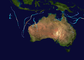
The 2009–10 Australian region cyclone season was a below average tropical cyclone season, with eight tropical cyclones forming compared to an average of 12. The season began on 1 November 2009 and ran through until it end on 30 April 2010. The Australian region is defined as being to south of the equator, between the 90th meridian east and 160th meridian east. Tropical cyclones in this area are monitored by five Tropical Cyclone Warning Centres (TCWC's): Jakarta, Port Moresby, Perth, Darwin, and Brisbane, each of which have the power to name a tropical cyclone. The TCWC's in Perth, Darwin, and Brisbane are run by the Australian Bureau of Meteorology, who designate significant tropical lows with a number and the U suffix. The Joint Typhoon Warning Center also issues unofficial warnings for the region, designating significant tropical cyclones with the "S" suffix when they form west of 135°E, and the "P" suffix when they form east of 135°E.

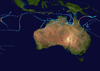
The 2010–11 Australian region cyclone season was a near average tropical cyclone season, with eleven tropical cyclones forming compared to an average of 12. The season was also the costliest recorded in the Australian region basin, with a total of $3.62 billion in damages, mostly from the destructive Cyclone Yasi. The season began on 1 November 2010 and ended on 30 April 2011, although the first tropical cyclone formed on 28 October. The Australian region is defined as being to the south of the equator, between the 90th meridian east and 160th meridian east. Tropical cyclones in this area are monitored by five Tropical Cyclone Warning Centres (TCWC's): Jakarta, Port Moresby, Perth, Darwin, and Brisbane, each of which have the power to name a tropical cyclone. The TCWC's in Perth, Darwin, and Brisbane are run by the Bureau of Meteorology, who designate significant tropical lows with a number and the U suffix. The Joint Typhoon Warning Center also issues unofficial warnings for the region, designating significant tropical cyclones with the "S" suffix when they form west of 135°E, and the "P" suffix when they form east of 135°E.
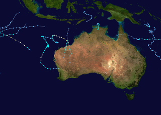
The 2011–12 Australian region cyclone season was a below average tropical cyclone season, with 7 cyclones forming rather than the usual 11. It began on 1 November 2011, and ended on 14 May 2012. The regional tropical cyclone operational plan defines a "tropical cyclone year" separately from a "tropical cyclone season"; the "tropical cyclone year" began on 1 July 2011 and ended on 30 June 2012.

The 1990–91 Australian region cyclone season was a slightly below average cyclone season, with ten tropical cyclones occurring within the region between 90°E and 160°E. The season officially ran from November 1, 1990, to April 30, 1991, with the first disturbance of the season forming on 10 December and the last disturbance moving out of the region during 11 May. Six people were killed by Cyclone Joy when it made landfall on Australia. During the season, tropical cyclones were monitored by the Australian Bureau of Meteorology, who ran Tropical Cyclone Warning Centers (TCWC) in Perth, Darwin, and Brisbane. The United States Joint Typhoon Warning Center (JTWC) and Papua New Guinea National Weather Service also monitored systems within the basin during the season. The JTWC designated systems with a number and either a S or a P suffix depending on which side of 135E. The Bureau of Meteorology and Papua New Guinea national Weather Service both used the Australian Tropical Cyclone Intensity Scale, and estimated windspeeds over a ten-minute period, while the JTWC estimated sustained winds over a one-minute period and are comparable to the Saffir–Simpson Hurricane Scale.
The 2012–13 Australian region cyclone season was a slightly below average tropical cyclone season event in the ongoing cycle of tropical cyclone formation. It officially started on 1 November 2012, and officially ended on 30 April 2013, despite Cyclone Zane being an active system at the time. The regional tropical cyclone operational plan defines a "tropical cyclone year" separately from a "tropical cyclone season"; the "tropical cyclone year" began on 1 July 2012 and ended on 30 June 2013.
The 2013–14 Australian region cyclone season was a slightly below-average tropical cyclone season, with 10 tropical cyclones occurring within the Australian region. It officially started on 1 November 2013, and ended on 30 April 2014. The regional tropical cyclone operational plan defines a "tropical cyclone year" separately from a "tropical cyclone season"; the "tropical cyclone year" began on 1 July 2013 and ended on 30 June 2014.

The 2016–17 Australian region cyclone season, despite a very high number of tropical lows, was a slightly below-average season in terms of activity, with nine tropical cyclones, three of which intensified further into severe tropical cyclones; though it was much more active than the previous season. The season was the first to have a severe tropical cyclone since the 2014–15 season. It was the period of the year when most tropical cyclones form in the Southern Indian Ocean and Pacific Oceans between 90°E and 160°E. The season officially ran from 1 November 2016 to 30 April 2017, however, a tropical cyclone could form at any time between 1 July 2016 and 30 June 2017 and would count towards the season total. The first named storm, Yvette, developed during 21 December, and the final named storm, Greg, left the region on 3 May as a remnant low. This season was also the second-costliest tropical cyclone season on record in the Australian region basin, behind only the 2010–11 season, with a total of AUD$3.7 billion in damages incurred by the various storms, mostly from Cyclone Debbie.

The 1994–95 Australian region cyclone season was a below average Australian cyclone season. It was also an event in the ongoing cycle of tropical cyclone formation. It ran from 1 November 1994 to 30 April 1995. The regional tropical cyclone operational plan also defines a tropical cyclone year separately from a tropical cyclone season, and the "tropical cyclone year" ran from 1 July 1994 to 30 June 1995.

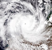
Severe Tropical Cyclone John was an intense tropical cyclone that rapidly deepened offshore before devastating areas of Western Australia. The system was the second cyclone and first severe tropical cyclone of the active 1999–00 Australian region cyclone season. Cyclone John developed from a monsoon trough positioned northwest of Australia on 9 December 1999. As it moved to the west and later south as the result of a subtropical ridge under favourable conditions, the cyclone was able to rapidly intensify. John reached peak intensity on 14 December as a Category 5 cyclone on the Australian cyclone scale, the highest rating possible. Cyclone John later began interacting with a mid–latitude trough, which slightly weakened the cyclone prior to making landfall near Whim Creek early on 15 December. Increasingly unfavourable conditions further inland resulted in the cyclone's rapid weakening, before it dissipated during the next day.

Severe Tropical Cyclone Heidi was a small and strong tropical cyclone that struck Western Australia in January 2012. The seventh tropical low, third tropical cyclone, and second severe tropical cyclone of the 2011–12 Australian region cyclone season, Heidi developed from a tropical low that formed to the south of Indonesia on 9 January, before strengthening into a Category 1 tropical cyclone on the following day. Tracking southward towards the Pilbara coast in a favourable environment, Heidi rapidly intensified and attained Category 3 severe tropical cyclone status on 11 January. After making landfall at peak intensity later that day with estimated winds of 150 km/h (95 mph), Heidi rapidly weakened, dissipating over Western Australia by 13 January.

Severe Tropical Cyclone Carlos was a strong tropical cyclone that made landfall in Australia and resulted in $12.3 million USD in damages. Carlos was first spotted on 14 February near Batchelor and intensified to a Category 3 cyclone on 22 February. The storm affected Australia for most of its life.


