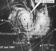
 Satellite image of Cyclone Dinah on 27 January | |
| Meteorological history | |
|---|---|
| Formed | 22 January 1967 |
| Dissipated | 3 February 1967 |
| Category 4 severe tropical cyclone | |
| 10-minute sustained (BOM) | |
| Highest winds | 195 km/h (120 mph) |
| Lowest pressure | 944.8 hPa (mbar);27.90 inHg |
| Category 2-equivalent tropical cyclone | |
| 1-minute sustained (SSHWS/JTWC) | |
| Highest winds | 155 km/h (100 mph) |
| Overall effects | |
| Fatalities | 1 total |
| Missing | 1 |
| Damage | Severe |
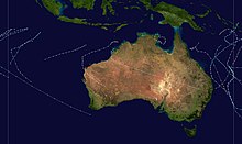
| Areas affected | Queensland,New South Wales,New Zealand |
Part of the 1966–67 South Pacific and Australian region cyclone seasons | |
Severe Tropical Cyclone Dinah was an intense tropical cyclone that impacted the southern coasts of Queensland and New South Wales,causing floods and landslides in 1967. It was regarded by an official in the Bureau of Meteorology's Brisbane Tropical Cyclone Warning Centre as the strongest storm to approach the southern coasts of Queensland since reliable records began. Forming on January 22 in the South Pacific basin,nearly 620 kilometers to the southeast of Honiara in the Solomon Islands,the disturbance that would eventually be Dinah remained disorganized until the next day when the system started to organize under the warm waters of the Coral Sea. On January 24,the disturbance was upgraded to a tropical cyclone by the BoM and was named Dinah,being the fifth storm in the records of the meteorology center of Australia in the 1966–67 Australian region cyclone season. Environmental conditions favoured Dinah to further intensify,becoming a severe tropical cyclone on January 27 while recurving south-southwestwards. On the next day,it passed through the Great Barrier Reef as a Category 4 severe tropical cyclone before passing through Fraser Island on January 29,where the Sandy Cape Lighthouse recorded a minimum barometric pressure of 944.8 hPa on Dinah,being the lowest known pressure of the system. It then battered the whole island before turning south-southeastwards,away from the coast of Queensland. Weakening took place while slowing down,passing near Lord Howe Island as a Category 2 tropical cyclone before undergoing extratropical transition on January 31. Dinah became extratropical on the night of that day before accelerating eastward,approaching New Zealand. The system then turned southeastward for the final time before passing through the North Island. It reemerged on the Southern Pacific Ocean on February 3,where it dissipated.
Contents
- Meteorological history
- Preparations and impact
- Queensland and New South Wales
- New Zealand
- Retirement
- See also
- References
- External links
According to a study,Dinah caused the largest waves being observed in the southern part of Queensland in centuries. The system also inflicted extensive damage on Heron Island during its passage to the southern part of the state,starting with the flooding of massive north-easterly swellings and a day later with heavy winds. Although Dinah remained offshore,its outer rainbands caused heavy rains and gusty winds that uprooted trees,starting from Rockhampton Region to Grafton in New South Wales. Some residential institutions lost their roofs due to the wind,while banana and sugarcane crops were destroyed and inundated by floodwaters. Severe erosions were reported in Emu Park and Maryborough-Bundaberg areas. Massive rainfall amounts were recorded in some parts of Queensland,New South Wales and New Zealand's North Island as the extratropical remnant. Storm surges were also seen on Sunshine Coast,Queensland. Tourists on Lord Howe Island were stranded by the storm,while many residents had to be rescued on different beaches due to large swells. A man in North Island in New Zealand was feared drowned due to Dinah,while another was missing due to his car being submerged in floods. The damage was described as severe,but the numerical amounts were unknown.