Cyclone George

Last updated

Map key
  Tropical depression (≤38 mph, ≤62 km/h)
  Tropical storm (39–73 mph, 63–118 km/h)
  Category 1 (74–95 mph, 119–153 km/h)
  Category 2 (96–110 mph, 154–177 km/h)
  Category 3 (111–129 mph, 178–208 km/h)
  Category 4 (130–156 mph, 209–251 km/h)
  Category 5 (≥157 mph, ≥252 km/h)
  Unknown
Storm type
Disc Plain black.svg Tropical cyclone
Solid black.svg Subtropical cyclone
ArrowUp.svg Extratropical cyclone, remnant low, tropical disturbance, or monsoon depression

On 24 February 2007, an area of low pressure began consolidating over the Arafura Sea. By 26 February, the Bureau of Meteorology (BOM) warning centre in Darwin classified the system as a tropical low with its centre situated 230 km (140 mi) northwest of Nhulunbuy. Over the following days, the system meandered around the Top End region and showed signs of gradual organisation. Initial forecasts depicted the low as moving gradually eastward and becoming a significant cyclone over the Gulf of Carpentaria; however, after approaching Milingimbi Island on 1 March, the system doubled back to the west in response to a subtropical ridge over central Australia. [1] [2] Though overland, the cyclone remained well-organized (a typical occurrence for tropical lows over Top End). Deep convection blossomed on 2 March, as the system approached the Joseph Bonaparte Gulf. [1] Owing to favourable upper-level outflow and decreasing wind shear, the Joint Typhoon Warning Center (JTWC) issued a Tropical Cyclone Formation Alert for the system that day. [2] The agency estimated the formation of a tropical depression, assigning it the identifier 17S, by 00:00  UTC (9:30 a.m. ACST) on 3 March while it was still over land. [3] Hours later, the low emerged over the Gulf and acquired gale-force winds while situated 75 km (47 mi) south-southeast of Gunbalanya. [1] In light of this, the Darwin warning centre initiated advisories on Tropical Cyclone George, [4] marking the first time since Cyclone Fay, in 2004, that the Darwin office named a storm. [1]

George quickly intensified once offshore, with a very small banding eye of approximately 8 km (5.0 mi) in diameter appearing on SSMI satellite imagery, [2] [5] and gained winds of 95 km/h (60 mph) by 18:00 UTC (3:00 a.m. AWST on 4 March). [1] The system subsequently made landfall in the Kimberley region of Western Australia at that intensity hours later. [4] Substantial structural degradation took place over land, with the eye feature dissipating, [2] and the BOM estimated the system to have briefly weakened to a tropical low before emerging over the extreme eastern Indian Ocean late on 4 March. [4] Once offshore, George regained tropical cyclone strength as it moved steadily west away from Australia. Intensification was slow due to a lack of outflow and increased wind shear. [1] Over the following few days, most forecast models indicated that George would gradually turn to the south as it rounded the subtropical ridge and possibly strike areas between Exmouth and Onslow by 9 March. The models continued to indicate this scenario through 6 March, resulting in a high-confidence forecast from the Perth warning centre. [6]

Cyclone George at landfall on 8 March, 2007 George 2007-03-08 1715Z.jpg
Cyclone George at landfall on 8 March, 2007

However, on 7 March George took an abrupt, nearly 90 degree left turn through a weakness in the ridge and began moving almost due south. [1] This turn caught meteorologists almost entirely off-guard, with only the United Kingdom Met Office ensemble model depicting this scenario. Post-storm reviews of the forecasting failure pointed toward four factors that may have influenced George at the time but were not initialised by the models: the extratropical transition of Cyclone Humba well upstream over the Indian Ocean, a Fujiwhara interaction with Cyclone Jacob to the northwest, the Beta drift effect, and poorly represented monsoonal flow. Of these factors, the monsoonal flow was determined to have been the main cause in the poor track forecast as models did not capture the degree of influence of these winds on the cyclone. [6] This resulted in the forecast track for George having the greatest error of any cyclone in the Western Australian region in at least five years. The average error of 477 km (296 mi) at 48 hours was comparable to the average accuracy of forecasts in the 1980s. [4]

Coinciding with George's turn south was a notable improvement of environmental factors. Wind shear, previously inhibiting organisation, began to decrease while a nearby upper-level low enhanced the system's outflow. [1] The favourable condition allowed for an increase in both strength and size, with both the BOM and JTWC estimating the cyclone to have attained hurricane-force winds by 12:00 UTC (8:00 pm. AWST) on 7 March. [3] [4] [nb 1] By early on 8 March, George featured an area of gale-force winds spanning nearly 400 km (250 mi) across, significantly larger than average. [4] A large cloud-filled eye soon developed before a sudden period of rapid intensification ensued. [2] [5] During this phase, the cyclone's eye steadily contracted to a minimum diameter of roughly 22 km (14 mi). [5] Between 09:00 and 10:00 UTC (5:00–6:00 pm. AWST) on 8 March, George passed directly over Bedout Island. [1] As the eyewall moved over the island, a record-breaking ten-minute sustained wind speed of 194 km/h (121 mph) was measured, until it was surpassed by Cyclone Ilsa in 2023. [7] Based on the extreme winds measured on Bedout and additional intensification thereafter, George was estimated to have reached its peak intensity at 12:00 UTC (8:00 pm. AWST) with winds of 205 km/h (125 mph) and an estimated barometric pressure of 902  mbar (hPa; 26.64  inHg). [4] Automated Dvorak classifications from the Cooperative Institute for Meteorological Satellite Studies at University of Wisconsin–Madison peaked at 6.8, equivalent to a high-end Category 4 on the Saffir–Simpson hurricane wind scale, as the storm moved ashore. [8]

At 10 p.m on 8 March, Cyclone George made landfall 50 kilometres (31 mi) north-east of Port Hedland. [9] When it made landfall, it was still at its peak intensity. [9] Damaging wind gusts of 154 kilometres per hour (96 mph) were recorded at Port Hedland Airport weather station just before 11 pm. [10] The anemometer failed shortly afterwards. [10] At 00:12 on 9 March, an air pressure reading of 962.7 hectopascals (28.43 inHg) was recorded at Port Hedland Airport; this was lowest recorded at the airport during the passage of the cyclone. [10] George weakened slowly while over land and it was downgraded to a Category 3 late on 9 March. The next day, the Tropical Cyclone Warning Centre in Perth issued its final warning for the system. George's remnants continued drifting southeastward and then southward over the next 3 days, before dissipating on 13 March, in southern Australia.

Preparations

Cyclone George resulted in numerous schools and ports in Port Hedland being closed down to deal with the severe cyclone. [11] Mining and Oil & Gas companies had to ultimately close to also deal with the threat of the imminent cyclone. People were additionally evacuated from low lying levels near the sea, and moved either to higher ground, or further inland to Cyclone Shelters. [12]

Impact

Northern Territory

Effects from the precursor low to George in Northern Territory

As a developing tropical low, George produced prolonged heavy, in some cases record-breaking, rain across much of Northern Territory in late February through early March. [13] The most prolific rains took place as the system strengthened and began moving away from the region. In a five-day span, numerous areas saw more than a month's worth of precipitation. [14] Several towns and cities saw single-day rainfall records for March shattered by the system most notably Jabiru Airport with 393.4 mm (15.49 in) falling on 1 March, more than three times the previous highest. Other places that broke daily records include Adelaide River, Black Point, Channel Island, Elizabeth Valley, Howard Springs, Mango Farm, Gunbalanya, Territory Wildlife Farm, Thorak Cemetery, and Walker Creek. The tremendous rains also resulted in many areas seeing their wettest March on record. [13]

Widespread flooding resulted from the rains in the region, with some areas becoming isolated by 2 March. [15] Extensive damage was incurred by region's roadways, with losses reaching $12 million. Officials referred to the effects of the flooding as the worst in 40 years. [16] Portions of the Kakadu and Arnhem highways were shut down, with the latter expected to remain so for a week. [15] Throughout the Top End region, a collective 101 bridges and roads were closed due to flooding. [17] Workers at the Ranger Uranium Mine in Jabiru were forced to camp out at the mine as floodwaters overtook the area. [15] The mine's pit was inundated and forced to shut down for nine days while processing had to be suspended for two weeks. The resulting loss in production cost Energy Resources of Australia 300  tonnes (330  tons) of uranium. According to resource analysts, the negative impacts of the flood in addition to lingering effects from Cyclone Monica in 2006 would result in a two percent decrease in the global supply of uranium by 2008. [18] Economic losses sustained by the Energy Resources of Australia were estimated to reach $200 million. [19] At least one house nearby was submerged. [15]

Just south of Jabiru, 35 people were airlifted from the Gagudju Lodge in Cooinda. [20] Helicopters were used to drop food to personnel stranded at outstations in the Kakadu National Park. [15] Severe storms in the park spawned a rare tornado near the Mary River Ranger Station. The 300 m (980 ft) wide twister levelled trees and destroyed caravans along a 3 km (1.9 mi) path. In some cases, trees were even debarked. [21] Based on the damage, the tornado was estimated to have had winds between 230 and 270 km/h (140 and 170 mph). [1] Severe thunderstorms battered Darwin on 3 March with frequent lightning, torrential rain, and destructive wind gusts up to 120 km/h (75 mph). Downed trees and power lines left 10,000 residents without electricity and flooded roadways isolated some in suburban areas. [22] [23] Flight delays were common at Darwin International Airport, while two had to be cancelled. [22] Four people in Adelaide River required rescue from their home. Debris from flooding in the town left main street and a nearby bridge impassible. [24]

The most severe flooding took place in Gunbalanya which saw roughly 930 mm (37 in) of rain in less than a week. [25] Evacuation of 90 people from 47 homes in the town took place on 3 March as rising waters from the local billabong became contaminated with sewage. [24] [26] Residents initially attempted to protect their homes with sandbags but waters rose too fast and over-topped the barrier. [27] Waters reached halfway up homes in the lowest lying areas, with high tide expected to reach 7.2 m (24 ft) on 4 March. [26] Waters began subsiding in the town by 6 March, though low-lying areas remained partially submerged. [28] More than 60 homes sustained flood-related damage. [25] The local school and its library sustained extensive damage, with the latter being damaged beyond repair. [28] An estimated 350 of the 1,400 cattle kept in paddocks near the community were swept away during the flood; [29] at least 70 were known to have drowned by 7 March. [30]

Western Australia

Severe Tropical Cyclone George
George 2007-03-08 1150Z.jpg
Cyclone George making landfall on Western Australia at peak intensity on 8 March
Most intense Australian cyclones
RankCycloneYearMin. pressure
1 Gwenda 1999 900  hPa (26.58  inHg)
Inigo 2003
3 George 2007 902 hPa (26.64 inHg)
4 Orson 1989 905 hPa (26.72 inHg)
Marcus 2018
6 Theodore 1994 910 hPa (26.87 inHg)
Vance 1999
Fay 2004
Glenda 2006
Source: Australian Bureau of Meteorology [31]

Cyclone George was the most powerful cyclone to hit Port Hedland since Cyclone Joan in 1975. [9] The cyclone's peak intensity of 902 hPa (26.64 inHg) with wind gusts of up to 285 kilometres per hour (177 mph) was estimated following Dvorak analysis of satellite imagery. [32]

Power and telephone lines were down in Port Hedland, many roofs and fences were torn down and trees were uprooted. [33] At least one house was destroyed. [34] The Pilbara region was declared a disaster zone, and the Australian Defence Force was on standby to provide extra help. [35] At around 10 p.m on 8 March, the Bureau of Meteorology's Port Hedland weather radar was damaged by the cyclone and was offline for nearly a day. [10] Tropical Cyclone Jacob struck almost the same area as George only three days later, although it was not as damaging or deadly as George. It did however cause some minor flooding. [36]

Three people were killed and twenty-eight others were injured as a result of the severe cyclone. One death and the majority of the people injured occurred at a Fortescue Metals Group camp, [37] about 100 km (62.13 mi) south of Port Hedland. [38] Strong winds and flooding delayed the rescue efforts for most of the day. [35] However, all injured workers were airlifted to the hospital in Port Hedland after the cyclone passed. [38] The deaths occurred when strong winds knocked over temporary accommodation shelters known as dongas. The second death occurred at Indee station, located between Port Hedland and the mining camp. [35] The man died from severe internal injuries while escaping from his wrecked donga, trying to seek help at the main station homestead. [39] A third death occurred when a man who was transferred to a Perth hospital on 11 March died due to the injuries received when the cyclone hit at the Fortescue camp. [40]

Aftermath

Northern Territory

Starting on 7 March, the Gunbalanya Health Clinic began warning residents of a possible melioidosis outbreak resulting from the floods. They urged residents to wear shoes and wash their hands before eating to avoid infection. [41] More than a dozen people contracted the disease over the following weeks, with two dying as a result. Three others were hospitalised in the Royal Darwin Hospital. [42] Reconstruction of roads in and around Darwin began by 9 March; however, portions of the Arnhem Highway remained under water. The Department of Planning and Infrastructure stated that a 15 m (49 ft) bridge would have to be constructed over the West Alligator River where a culvert collapsed. [43] The $1.2 million bridge was completed on 5 April and allowed Arnhem Highway to completely re-open. [44] Repair work on roads continued for more than a month, with additional rains in the following weeks creating additional potholes. [16] A week after the floods, there was some concern over a delay in aid from the government; however, authorities assured that supplies would be provided in a timely manner once need assessments were complete. [45] The Salvation Army began collecting supplies for the 90 people rendered homeless by 13 March with additional requests for assistance made to the Australian Red Cross. [46] Shipments of supplies to Gunbalanya began on 20 March, with a total of 14 flights scheduled over two days. The airlifts brought more than $200,000 worth of goods, consisting of mattresses, blankets, sheets, refrigerators, washing machines, and stoves, to the community. [47]

Western Australia

Cyclone George weakening inland over Western Australia on 9 March George 09 mar 2007 0525Z.jpg
Cyclone George weakening inland over Western Australia on 9 March

On 9 March, Prime Minister John Howard announced that persons injured by the storm or those whom lost their home would be eligible for funding through the Australian Government Disaster Recovery Payment program. The initiative ultimately provided 530 people with a collective $630,000 in aid. [48]

After Cyclone George struck the Pilbara coast, a relief fund was set up to help the victims of the storm. Mining companies, business, and residents all donated money to assist with the cause, and within 48 hours the town of Port Hedland was able to raise just over $520,000 [49] BHP also helped recover Port Hedland by giving the local government $1 million each year which will fund for a large part of an enhancement scheme with the Western Australian State Government to improve the town's appearance. Schools in South Hedland remained closed due to safety concerns about the damage caused by cyclones George and Jacob until 19 March, after the local community joined in a massive clean-up. [50]

In commemoration of the deaths that took place, the Fortescue Metals Group commissioned the McNally Newton Landscape Architects to construct a memorial in South Hedland. Acclaimed sculptor Ron Gomboc designed a 12 m (39 ft) twisted, steel monument for the project. The memorial was opened in March 2009, two years after the storm. [51]

Lawsuits

The Australian Workers' Union (AWU) launched a scathing attack on the Fortescue Metals Group, saying they were disgraced that no evacuation took place before the cyclone hit. The AWU were also concerned about the buildings at the campsite as they were only built to withstand a Category 2 cyclone. Almost all of the buildings located at the camp site were destroyed. [40] Fortescue and its subsidiary the Pilbara Infrastructure (TPI) were charged with a combined 18 counts of failing to provide or maintain a safe workplace over Cyclone George and appeared in Perth Magistrates Court. [52] The Magistrate dismissed all charges and when that decision was appealed to the Supreme Court of Western Australia the appeal was also dismissed, with Justice Stephen Hall finding that Fortescue had met their duty to provide a safe workplace by engaging "qualified and experienced experts" to manage the dongas. [53] Both courts had heard that the company contracted to build the dongas, NT Link, had given assurances to Fortescue that the dongas had been constructed to industry standards when it had not. [52] NT Link was granted immunity from prosecution in exchange for its testimony against Fortescue. [54]

See also

Notes

  1. Hurricane-force winds are equivalent to 119 km/h (74 mph) or greater.

Related Research Articles

<span class="mw-page-title-main">Cyclone Thelma</span>

Severe Tropical Cyclone Thelma was a tropical cyclone that affected northern Australia from 6 December 1998 until 12 December 1998. Cyclone Thelma was one of the most intense tropical cyclones to be observed off the coast of Australia. Thelma formed in the Arafura Sea north of the Northern Territory while intensifying rapidly into a Category 5 cyclone, passing very near the Tiwi Islands and posing a severe threat to Darwin, but passed by at a distance of 200 km (120 mi). It then moved across the Timor Sea before hitting the north Kimberley coast. Thelma was the first known Category 5 cyclone to be observed in the Timor Sea, and was also the most intense cyclone to threaten Darwin since Cyclone Tracy on Christmas Eve in 1974. Ten months after the storm's passage, the skull of an 81-year-old man, who was believed to have been swept away by flood waters, was discovered.

<span class="mw-page-title-main">Cyclone Steve</span> Category 3 Australian region cyclone in 2000

Tropical Cyclone Steve was a tropical cyclone that affected northern Australia from 27 February 2000 until 11 March 2000. Cyclone Steve was noted for its longevity and traversal of northern and western Australia. It impacted on regions of northern Queensland, the Northern Territory and Western Australia before clearing to the south of the continent. Steve is the first known Australian cyclone to make four distinct landfalls in the country.

<span class="mw-page-title-main">1999–2000 Australian region cyclone season</span>

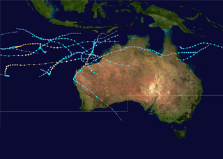
The 1999–2000 Australian region cyclone season was a slightly above average tropical cyclone season. It ran from 1 November 1999 to 30 April 2000. The regional tropical cyclone operational plan also defines a "tropical cyclone year" separately from a "tropical cyclone season", with the "tropical cyclone year" for this season lasting from 1 July 1999 to 30 June 2000.

<span class="mw-page-title-main">2006–07 Australian region cyclone season</span> Tropical cyclone season

The 2006–07 Australian region cyclone season was a below average tropical cyclone season. It began on 1 November 2006 and ended on 30 April 2007; however, Tropical Cyclone Pierre formed on 17 May, after the official end date. The regional tropical cyclone operational plan also defines a tropical cyclone year separately from a tropical cyclone season, which runs from 1 July 2006 to 30 June 2007.

<span class="mw-page-title-main">2008–09 Australian region cyclone season</span> Tropical cyclone season

The 2008–09 Australian region cyclone season was a near average tropical cyclone season. It officially started on 1 November 2008, and officially ended on 30 April 2009. This season was also the first time that the BoM implemented a "tropical cyclone year." The regional tropical cyclone operational plan defines a "tropical cyclone year" separately from a "tropical cyclone season"; the "tropical cyclone year" began on 1 July 2008 and ended on 30 June 2009.

<span class="mw-page-title-main">1995–96 Australian region cyclone season</span>

The 1995–96 Australian region cyclone season was an active Australian cyclone season, with Western Australia experiencing a record number of landfalling intense storms in the Pilbara region. The season produced a total of 19 tropical cyclones, of which 14 developed into named storms and 9 reached severe tropical cyclone status. The strongest of the season was Severe Tropical Cyclone Olivia, which also produced the highest recorded wind gust on record of 408 km/h (253 mph). Though several systems impacted land, the general sparsity of population centres in Australia limits the scale of damage. One person was confirmed to have been killed and cumulative losses were estimated at A$77 million (US$58.5 million).

<span class="mw-page-title-main">2010–11 Australian region cyclone season</span> Tropical cyclone season

The 2010–11 Australian region cyclone season was a near average tropical cyclone season, with eleven tropical cyclones forming compared to an average of 12. The season was also the costliest recorded in the Australian region basin, with a total of $3.62 billion in damages, mostly from the destructive Cyclone Yasi. The season began on 1 November 2010 and ended on 30 April 2011, although the first tropical cyclone formed on 28 October. The Australian region is defined as being to the south of the equator, between the 90th meridian east and 160th meridian east. Tropical cyclones in this area are monitored by five Tropical Cyclone Warning Centres (TCWC's): Jakarta, Port Moresby, Perth, Darwin, and Brisbane, each of which have the power to name a tropical cyclone. The TCWC's in Perth, Darwin, and Brisbane are run by the Bureau of Meteorology, who designate significant tropical lows with a number and the U suffix. The Joint Typhoon Warning Center also issues unofficial warnings for the region, designating significant tropical cyclones with the "S" suffix when they form west of 135°E, and the "P" suffix when they form east of 135°E.

<span class="mw-page-title-main">Cyclone Gwenda</span> Category 5 Australian region cyclone in 1999

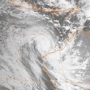
Severe Tropical Cyclone Gwenda is tied with Cyclone Inigo as the most intense Australian tropical cyclone on record, with a barometric pressure of 900 hPa (mbar) and was the most intense storm worldwide in 1999. Forming out of a tropical disturbance over the Arafura Sea on 2 April 1999, the precursor to Gwenda tracked slowly westward and gradually became more organised. On 4 April, the system developed into a Category 1 cyclone and was named Gwenda. It began to undergo explosive intensification the following day, and in a 30-hour span ending early on 7 April, the storm's maximum 10-minute sustained wind speed increased from 75 to 225 km/h and its barometric pressure decreased to 900 hPa (mbar). The Joint Typhoon Warning Center reported that the storm had peaked as a high-end Category 4 equivalent on the Saffir–Simpson hurricane scale.

<span class="mw-page-title-main">Cyclone Olivia</span> Category 4 region cyclone in 1996

Severe Tropical Cyclone Olivia was a powerful cyclone, the 13th named storm of the 1995–96 Australian region cyclone season, which formed on 3 April 1996 to the north of Australia's Northern Territory. The storm moved generally to the southwest, gradually intensifying off Western Australia. On 8 April, Olivia intensified into a severe tropical cyclone and subsequently turned more to the south, steered by a passing trough. On the morning of 10 April, passing over Barrow Island off the Western Australian northwest coast, Olivia produced the strongest non-tornadic winds ever recorded, with peak gusts of 408 kilometres per hour (254 mph). On the same day the cyclone made landfall on the Pilbara coast, about 75 kilometres (47 mi) north-northwest of Pannawonica. The storm quickly weakened over land, dissipating over the Great Australian Bight on 12 April.

<span class="mw-page-title-main">Cyclone Clare</span> Category 3 Australian region cyclone in 2006

Severe Tropical Cyclone Clare was a moderately strong cyclone that struck Western Australia in January 2006. The storm formed as an area of low pressure in the Arafura Sea, and moved westward. After receiving the name Clare on 7 January, the system ultimately peaked at Category 3 intensity on the Australian tropical cyclone scale. It moved ashore on the coast of the Pilbara and proceeded inland, dissipating on 10 January. Clare produced winds of 142 km/h (88 mph) at Karratha and triggered widespread torrential rainfall that led to flooding. Following its usage, the name Clare was retired by the Bureau of Meteorology, and will never be used again for a tropical cyclone in the area.

<span class="mw-page-title-main">Cyclone Joan</span> Category 5 Australian region cyclone in 1975

Severe Tropical Cyclone Joan was an intense tropical cyclone that ravaged areas of Western Australia. Forming out of a tropical low on 30 November 1975, Joan gradually intensified as it tracked towards the west. After attaining Category 5 intensity on 5 December, the storm abruptly began to track southward and accelerated. The following day, the cyclone reached its peak intensity with winds of 215 km/h (130 mph) and a barometric pressure of 915 hPa (27.02 inHg). Joan only weakened slightly before making landfall in the vicinity of Mundabullagana. The cyclone rapidly weakened after landfall before dissipating over Western Australia on 12 December.

<span class="mw-page-title-main">Cyclone John</span> Category 5 Australian region cyclone in 1999

Severe Tropical Cyclone John was an intense tropical cyclone that rapidly deepened offshore before devastating areas of Western Australia. The system was the second cyclone and first severe tropical cyclone of the active 1999–00 Australian region cyclone season. Cyclone John developed from a monsoon trough positioned northwest of Australia on 9 December 1999. As it moved to the west and later south as the result of a subtropical ridge under favourable conditions, the cyclone was able to rapidly intensify. John reached peak intensity on 14 December as a Category 5 cyclone on the Australian cyclone scale, the highest rating possible. Cyclone John later began interacting with a mid–latitude trough, which slightly weakened the cyclone prior to making landfall near Whim Creek early on 15 December. Increasingly unfavourable conditions further inland resulted in the cyclone's rapid weakening, before it dissipated during the next day.

<span class="mw-page-title-main">Cyclone Rusty</span> Category 4 Australian region cyclone in 2013

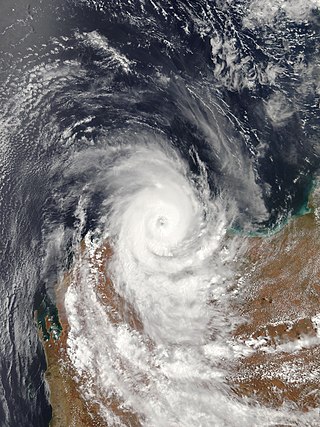
Severe Tropical Cyclone Rusty was a strong, slow-moving tropical cyclone that produced record duration gale-force winds in Port Hedland, Western Australia in late February 2013. Originating as an area of low pressure on 22 February well to the northwest of the Kimberley region of Western Australia, the precursor to Rusty steadily developed within a favourable environment. Gradually decreasing surface pressures in the region signaled intensification and the low was classified as Tropical Cyclone Rusty on 23 February. Although a large, sprawling system, near-record high sea surface temperatures enabled Rusty to quickly deepen. Becoming essentially stationary on 25 February, the system acquired hurricane-force winds as its core improved in structure. The cyclone achieved its peak intensity two days later with maximum ten-minute sustained winds of 165 km/h (105 mph) and a barometric pressure of 944 hPa. Thereafter, interaction with land caused its core to collapse before the system made landfall near Pardoo Station. Rusty weakened below cyclone strength on 28 February. Its remnants persisted over Western Australia for several more days before being absorbed into an extratropical cyclone on 5 March.

<span class="mw-page-title-main">Cyclone Lua</span> Category 3 Australian region tropical cyclone in 2012

Severe Tropical Cyclone Lua affected a sparsely populated region of Western Australia during mid-March 2012. Originating in a broad low pressure area that formed northwest of Australia by 8 March, the storm was plagued by inhibiting wind shear for the duration of its formative stages. However, it gradually organised, and received the name Lua on 13 March. The cyclone meandered for the first several days of its existence, caught between weak and competing steering currents. After the cyclone drifted northwestward, a building ridge of high pressure to the north drove Lua southeastward toward the Pilbara region. Ultimately intensifying into an upper-end Category 3 severe tropical cyclone with maximum sustained 10-minute winds of 155 km/h (96 mph), Lua made landfall near the remote community of Pardoo, about 150 km (93 mi) east of Port Hedland. It steadily weakened as it progressed south over interior Western Australia, diminishing below tropical cyclone status on 18 March.

<span class="mw-page-title-main">Cyclone Christine</span>

Severe Tropical Cyclone Christine was the third tropical cyclone and the second severe tropical cyclone of the 2013–14 Australian region cyclone season. It made landfall on Western Australia's Pilbara coast nearly halfway between the major towns of Karratha and Port Hedland as a category 4 cyclone on midnight of 31 December 2013.

<span class="mw-page-title-main">Cyclone Bobby</span> Category 4 Australian region tropical cyclone in 1995

Severe Tropical Cyclone Bobby set numerous monthly rainfall records in parts of the Goldfields-Esperance regions of Western Australia, dropping up to 400 mm (16 in) of rain in February 1995. The fourth named storm of the 1994–95 Australian region cyclone season, Bobby developed as a tropical low embedded within a monsoon trough situated north of the Northern Territory coastline on 19 February. The storm gradually drifted southwestward and later southward under low wind shear, strengthening enough to be assigned the name Bobby by the Australian Bureau of Meteorology (BoM). The storm rapidly deepened as it approached the coast of Western Australia, and attained its peak intensity of 925 mbar at 0900 UTC on 24 February with 10-minute maximum sustained winds of 195 km/h (120 mph). After making landfall as a somewhat weaker cyclone near Onslow, the remnants of Bobby drifted southeastward, gradually weakening, before dissipating over the southern reaches of Western Australia.

<span class="mw-page-title-main">Cyclone Ilona</span> Category 2 Australian region cyclone

Severe Tropical Cyclone Ilona caused moderate damage across the Pilbara region of Western Australia in mid-December 1988. The system originated from a monsoon trough that coalesced into a tropical low over the Timor Sea on 12 December. The system initially moved southwest, before moving on a more westerly course. Steady intensification occurred and Ilona reached its peak strength on 17 December as a low-end severe tropical cyclone. A southward turn directed the cyclone toward Western Australia, and it made landfall near Mardie Station. The system subsequently degraded over land and dissipated on 19 December.

<span class="mw-page-title-main">Cyclone Veronica</span>

Severe Tropical Cyclone Veronica was a large and powerful tropical cyclone which brought major impacts to the Pilbara region of Western Australia during March 2019. The nineteenth tropical low, eighth tropical cyclone and fifth severe tropical cyclone on the 2018–19 Australian region cyclone season, Veronica first appeared as a tropical low near East Timor on 18 March 2019. The system was slow to develop initially while tracking southwestwards through the Timor Sea, but began to consolidate the following day. The storm was upgraded by the Australian Bureau of Meteorology (BOM) to a Category 1 tropical cyclone on the Australian scale at 18:00 UTC on 19 March, by which time a steady development trend had begun. Upon attaining Category 2 status at 06:00 UTC on 20 March, Veronica underwent a period of explosive intensification. The system became a severe tropical cyclone six hours later, and Category 4 just six hours after that. Veronica reached peak intensity at 06:00 UTC the following day as a high-end Category 4 severe tropical cyclone, with ten-minute sustained winds estimated at 195 km/h (120 mph), and a central barometric pressure of 938 hPa. The United States' Joint Typhoon Warning Center estimated that the system was generating one-minute sustained winds of 230 km/h (145 mph), equivalent to a mid-range Category 4 major hurricane on the Saffir-Simpson hurricane wind scale. Veronica proceeded to weaken very gradually over the following few days as it turned towards Western Australia's Pilbara coastline. The system weakened to Category 3 while located just off the Pilbara coast, where it became almost stationary for 24 hours. Veronica began to weaken more quickly as it accelerated westwards on 25 March, tracking parallel to the coast. The system was downgraded below tropical cyclone intensity on 26 March, and after making landfall on North West Cape later that day, the system began to track away from the Australian mainland. Ex-Tropical Cyclone Veronica dissipated on 31 March over the eastern Indian Ocean.

<span class="mw-page-title-main">Cyclone Heidi</span> Tropical cyclone in 2012

Severe Tropical Cyclone Heidi was a small and moderately-powerful tropical cyclone that struck Western Australia in January 2012. The seventh tropical low, third tropical cyclone, and second severe tropical cyclone of the 2011–12 Australian region cyclone season, Heidi developed from a tropical low that formed to the south of Indonesia on 9 January, before strengthening into a Category 1 tropical cyclone on the following day. Tracking southward towards the Pilbara coast in a favourable environment, Heidi rapidly intensified and attained Category 3 severe tropical cyclone status on 11 January. After making landfall at peak intensity later that day with estimated winds of 150 km/h (95 mph), Heidi rapidly weakened, dissipating over Western Australia by 13 January.

<span class="mw-page-title-main">Cyclone Damien</span> Category 2 Cyclone in 2020

Severe Tropical Cyclone Damien was the strongest cyclone to make landfall on the Western Australian coast since Cyclone Christine in 2013 and the second-strongest cyclone in the 2019–20 Australian region cyclone season after Cyclone Ferdinand. The fifth tropical low, and the third named storm of the 2019–20 Australian region cyclone season, Damien originated from a monsoon trough over Kimberley.

References

  1. 1 2 3 4 5 6 7 8 9 10 Gary Padgett; Kevin Boyle; Simon Clarke (26 May 2007). "Monthly Global Tropical Cyclone Summary: March 2007" (Report). Australia Severe Weather. Retrieved 1 January 2015.
  2. 1 2 3 4 5 "Tropical Cyclone George Joint Typhoon Warning Center Advisories". Joint Typhoon Warning Center. Australia Severe Weather. 9 March 2007. Retrieved 1 January 2015.
  3. 1 2 "Cyclone 17S (George) Best Track". Joint Typhoon Warning Center. United States Navy. 2008. Archived from the original (.TXT) on 4 March 2016. Retrieved 1 January 2015.
  4. 1 2 3 4 5 6 7 Meteorological Aspects of Severe Tropical Cyclone George's Impact on the Pilbara (PDF). Perth Tropical Cyclone Warning Centre (Report). Bureau of Meteorology. 12 October 2007. Retrieved 2 January 2015.
  5. 1 2 3 "Australian Tropical Cyclone Database: Past Tropical Cyclone Tracks" (.CSV). Bureau of Meteorology. 8 January 2015. Retrieved 8 January 2015.
  6. 1 2 Jim Davidson (5 November 2007). Challenging Aspects of Severe Tropical Cyclone George's Track Forecasts (PDF). Bureau of Meteorology (Report). World Meteorological Organization. Retrieved 2 January 2015.
  7. Bureau of Meteorology, Western Australia [@BOM_WA] (13 April 2023). "#CycloneIlsa has set a new preliminary Australian ten-minute sustained wind speed record of 218km/h at Bedout Island! Cyclone George was the previous record holder with 194km/h back in 2007 at the very same location!" (Tweet). Archived from the original on 13 April 2023 via Twitter.
  8. "Tropical Cyclone 17S Automated Dvorak Classifications" (.TXT). Cooperative Institute for Meteorological Satellite Studies. University of Wisconsin–Madison. 9 March 2007. Retrieved 4 January 2015.
  9. 1 2 3 "Severe Tropical Cyclone George". Previous Cyclones. Bureau of Meteorology. Retrieved 26 November 2011.
  10. 1 2 3 4 "Meteorological Aspects of Severe Tropical Cyclone George's Impact on the Pilbara" (PDF). Bureau of Meteorology. Retrieved 27 November 2011.
  11. WA towns brace for cyclone [ permanent dead link ], The Australian
  12. Cyclone disrupts WA oil, gas Archived 14 March 2007 at the Wayback Machine News.com.au
  13. 1 2 "Widespread flooding in the Top End while hot and wet in the south – Northern Territory in March 2007". Northern Territory Climate Services Centre. Bureau of Meteorology. 3 April 2007. Retrieved 4 January 2015.
  14. Julia Kogan (8 March 2007). "Month rain in five days". Darwin Palmerston Sun. p. 2.(subscription required)
  15. 1 2 3 4 5 Greg McClean (2 March 2007). "Miners stranded as floodwaters rise". Northern Territory News. p. 5.(subscription required)
  16. 1 2 "Storms leave $12m road bill". Northern Territory News. 17 April 2007. p. 2.(subscription required)
  17. "101 roads, bridges closed". Northern Territory News. 10 March 2007. p. 5.(subscription required)
  18. Michael Vaughan (3 April 2007). "ERA's output hit by flooding". Australian Financial Review. p. 17.(subscription required)
  19. Heavy rains play havoc with ERA output Sydney Morning Herald 3 April 2007
  20. Rainfall causes flooding in Oenpelli ABC News 2 March 2007
  21. "Tornado formed 3 weeks ago in Kakadu". Australian Broadcasting Corporation. 20 March 2007. Retrieved 10 January 2015.
  22. 1 2 Rebekah Cavanagh (3 March 2007). "Power out, rains cut roads". Northern Territory News. p. 7.(subscription required)
  23. "Storms douse Darwin, cut roads". Australian Broadcasting Corporation. 3 March 2007.(subscription required)
  24. 1 2 "Woman and children rescued from NT flood waters". Darwin, Australia. Australian Associated Press. 3 March 2007.(subscription required)
  25. 1 2 Northern Territory Disaster Risk Assessment (PDF) (Report). Government of Australia. 2013. p. 14. Archived from the original (PDF) on 5 January 2015. Retrieved 4 January 2015.
  26. 1 2 "Oenpelli braces for high tide". Sunday Territorian. 4 March 2007. p. 5.(subscription required)
  27. Rebekah Cavanagh (7 March 2007). "Family loses all in storm". Northern Territory News. p. 5.(subscription required)
  28. 1 2 Rebekah Cavanagh (6 March 2007). "Trail of damage in wake of late Wet". Northern Territory News. p. 4.(subscription required)
  29. "Oenpelli residents feared for their lives during flooding". Australian Broadcasting Corporation. 6 March 2007.(subscription required)
  30. "Cattle go missing in heavy floods". Northern Territory News. 7 March 2007. p. 5.(subscription required)
  31. "Australian Tropical Cyclone Database" (CSV). Australian Bureau of Meteorology. 30 June 2023. Retrieved 30 June 2023. A guide on how to read the database is available here.
  32. "Meteorological Aspects of Severe Tropical Cyclone George's Impact on the Pilbara" (PDF). Bureau of Meteorology. 2007. p. 4. Retrieved 27 November 2011.
  33. Cyclone George Geelong Advertiser 9 March 2007
  34. "Three reported dead after WA cyclone". ABC News. 2007. Archived from the original on 12 March 2007. Retrieved 26 November 2011.
  35. 1 2 3 Deadly cyclone's fury not spent [ permanent dead link ] The Daily Telegraph [ dead link ]
  36. Tropical Cyclone Jacob Impacts, Bureau of Meteorology, 5 March 2007.
  37. PM pledges extra funding for cyclone George victims [ permanent dead link ], ABC News Online, 9 March 2007.
  38. 1 2 At least two dead in George's wake [ permanent dead link ], The Golden Mail
  39. WA police launch probe into third cyclone death, ABC News Online, 15 March 2007.
  40. 1 2 Police to investigate cyclone deaths Archived 13 March 2007 at the Wayback Machine , ABC News Online, 11 March 2007.
  41. "Health warning for flooded oenpelli". Australian Broadcasting Corporation. 7 March 2007. Retrieved 4 January 2015.
  42. "NT flood disease kills 2". Australian Broadcasting Corporation. 17 March 2007.(subscription required)
  43. "NT floods bring $5m clean-up bill". Australian Broadcasting Corporation. 9 March 2007.(subscription required)
  44. "Highway re-opened". Northern Territory News. 5 April 2007. p. 3.(subscription required)
  45. "Govt denies delay in transporting emergency goods to oenpelli". Australian Broadcasting Corporation. 9 March 2007. Retrieved 4 January 2015.
  46. "Salvos work to assist in Oenpelli floods aftermath". Australian Broadcasting Corporation. 13 March 2007.(subscription required)
  47. "Flood relief airlifted into remote NT community". Australian Broadcasting Corporation. 20 March 2007.(subscription required)
  48. "Tropical Cyclone George 2007". Disaster Assist. Government of Australia. 4 November 2014. Archived from the original on 11 January 2015. Retrieved 10 January 2015.
  49. Money pours into cyclone George relief fund ABC News 16 March 2007.
  50. BHP Billiton offers funds advancement for cyclone-hit Port Hedland Archived 23 September 2007 at the Wayback Machine , ABC News, 19 March 2007.
  51. "Cyclone George Memorial Dedicated" (PDF). Emerge Associates. March 2009. Archived from the original (PDF) on 11 January 2015. Retrieved 10 January 2015.
  52. 1 2 'No peace' for family after Fortescue cleared of cyclone deaths, WA Today, 18 February 2011.
  53. Worksafe cyclone appeal dismissed Archived 21 February 2014 at the Wayback Machine , Nine MSN, 23 March 2013.
  54. DLA Piper successfully defends Fortescue Metals Group against Cyclone George charges DLA Piper 10 May 2012.