It has been suggested that this article be merged into 2016–17 Australian region cyclone season . (Discuss) Proposed since January 2025. |
Tropical storm (39–73 mph, 63–118 km/h)
Category 1 (74–95 mph, 119–153 km/h)
Category 2 (96–110 mph, 154–177 km/h)
Category 3 (111–129 mph, 178–208 km/h)
Category 4 (130–156 mph, 209–251 km/h)
Category 5 (≥157 mph, ≥252 km/h)
Unknown
On 5 April 2017, the Australian Bureau of Meteorology began monitoring a developing tropical low located in the northeast Indian Ocean, approximately 710 km (440 mi) east of Christmas Island. [1] The system had been tracking in a generally westwards direction during the previous few days as a weak area of low pressure, but had not been significant enough to warrant the issuance of tropical cyclone warnings. [2] The tropical low tracked south-westwards throughout the day of 5 April, before adopting a course to the south-southwest during the night. [1] On the morning of 6 April, sustained gale-force winds developed on the western side of the system. [1] [4] Despite the existence of these cyclone-strength winds, [5] [6] the Bureau of Meteorology still classified the storm as a tropical low because they did not extend more than halfway around the system. [7]
The storm continued its trend of steady intensification, and was upgraded to a Category 1 cyclone on the Australian tropical cyclone intensity scale by 12:00 UTC on 6 April. [1] The storm was assigned the name Ernie – the seventh tropical cyclone and sixth named storm of the 2016-17 Australian region cyclone season. [8] This intensification to Category 1 status marked the beginning of a period of explosive intensification lasting about 24–30 hours, which concluded with Ernie being upgraded to a Category 5 severe tropical cyclone at about 12:00 UTC on 7 April. [1] Upon strengthening to Category 5 intensity, the cyclone had 10-minute sustained winds of 205 km/h (127 mph), gusting to 285 km/h (177 mph). [9] Aided by favourable environmental conditions, including sea surface temperatures of 29–30 °C (84–86 °F), the cyclone maintained its Category 5 intensity for more than 12 hours, while still tracking to the south-southwest. [1] [9] Ernie continued to intensify gradually during this time, peaking with 10-minute sustained winds of 220 km/h (140 mph), gusts to 315 km/h (196 mph), and a central pressure of 922 hPa (27.23 inHg). [1] Its maximum one-minute sustained wind speed of 260 km/h (160 mph) at this time made the storm the equivalent of a lower-end Category 5 major hurricane on the Saffir–Simpson Hurricane Wind Scale (SSHWS). [2] [3]

Soon afterwards, the system turned to the west-southwest and encountered an unfavorable environment of increased wind shear, dryer air, and cooler sea surface temperatures, [1] [4] which caused Ernie to weaken. The storm was downgraded to Category 3 status by 12:00 UTC on 8 April, about one day after it reached Category 5 intensity. [1] Ernie's decline in strength was paused, though, when the system began to re-intensify a few hours later, on the morning of 9 April, local time. The renewed period of strengthening proved short-lived and meager, however, as Ernie began weakening again on the afternoon of the same day, before it could reattain Category 4 status. [1] The cyclone was downgraded below severe tropical cyclone status to Category 2 intensity by 12:00 UTC on 9 April, and then further to Category 1 intensity by 00:00 UTC on the following day. [1] Ernie weakened below tropical cyclone intensity by 06:00 UTC on 10 April, ending its short but significant 90-hour existence as a cyclone. [1] Gales persisted in the southern quadrants of the system for a number of hours despite its declassification, due to the steep pressure gradient caused by a high pressure ridge to the south. [1] Ex-Tropical Cyclone Ernie continued to track to the west-southwest, and later in a more southerly direction until the remnants of the system dissipated four days later.[ citation needed ]
Rapid intensification
Severe Tropical Cyclone Ernie was a particularly noteworthy cyclone due to its extremely rapid rate of intensification. On the morning of 6 April, when gale-force winds were present on the western side of the developing tropical low, the storm was predicted to remain relatively weak, and reach only a marginal Category 2 intensity by the early hours of 8 April local time. [4] [10] After that time, it was forecast to weaken gradually while tracking to the west-southwest. As time progressed, the system attained Category 2 intensity while located 720 km (450 mi) southeast of Christmas Island, and Ernie's maximum predicted strength was raised to Category 3. [4]
Soon, in defiance of even this raised intensity forecast, environmental conditions became near perfect for Ernie to intensify extremely rapidly, and to a high degree. The storm intensified to a Category 4 severe tropical cyclone by 06:00 UTC on 7 April, then reached Category 5 status at about 12:00 UTC. [1] [4] From this point on, the cyclone continued to strengthen further, however at a much less frenetic pace. [1] [9] Overall, Severe Tropical Cyclone Ernie intensified from a tropical low to a Category 5 severe tropical cyclone in just 24–30 hours. The Bureau of Meteorology labelled this period of explosive intensification as ‘extraordinary’ in the cyclone's severe weather report. [1]
Impacts
Throughout its existence, Ernie tracked generally southwards as it intensified, and then generally to the west-southwest as it weakened. [1] This track led the system to be located a considerable distance away from all land areas, including well to the northwest of Western Australia, well to the east of Christmas Island and the Cocos (Keeling) Islands, and well to the south of Indonesia. [1] Consequently, Ernie did not cause any known impacts on land in terms of property damage, heavy rain or strong winds and was not retired from the list of names used by the BOM. [1]
See also
- Weather of 2016 and 2017
- Tropical cyclones in 2016 and 2017
- Cyclone Gillian – intensified rapidly from Category 3 to Category 5 on the Australian scale in 24 hours in March 2014, in a similar area to Ernie
- Cyclone Gwenda – intensified explosively northwest of Australia in April 1999, with a 10-minute sustained wind increase of 150 km/h (93 mph) and pressure decrease of 90 hPa (mbar; 2.66 inHg) in 30 hours
- Cyclone Hellen – intensified explosively in the Mozambique Channel in March 2014 at a rate Metéo-France referred to as 'astounding' [11]
- Cyclone Ita – intensified explosively while approaching the Far North Queensland coast from Papua New Guinea in 2014
- Hurricane Patricia – the second strongest tropical cyclone worldwide with a pressure of 872 hPa (mbar; 25.75 inHg), intensified explosively in the eastern Pacific Ocean from a tropical storm to a Category 5 major hurricane on the Saffir–Simpson scale in 24 hours during October 2015
- Hurricane Wilma – the strongest Atlantic hurricane on record, intensified explosively in the Caribbean Sea from a Category 1 hurricane to a Category 5 major hurricane on the Saffir–Simpson scale in 24 hours during October 2005
- Typhoon Noru – a typhoon that explosively intensified from Category 1 to Category 5 in the Philippine Sea before slightly weakened and made landfall in the Philippines.
- Hurricane Jova – a major hurricane that became one of the fastest intensifying hurricanes on recorded in the Eastern Pacific basin during September 2023.
- Typhoon Forrest - a super typhoon that rapidly intensified and became one of the strongest tropical cyclones on record by minimum pressure. Forrest also holds the record for the fastest rapid intensification period.
Related Research Articles

The 1942 Atlantic hurricane season was one of seven seasons to feature multiple hurricane landfalls in Texas. The season officially lasted from June 16, 1942, to October 31, 1942. These dates conventionally delimit the period of each year when most tropical cyclones form in the Atlantic basin. A total of 11 tropical storms from 1943 are listed in the Atlantic hurricane database, with two additional tropical depressions. The first system of the year, a tropical depression, developed over the central Gulf of Mexico on June 3, while the last system, the Belize hurricane, dissipated over the Yucatán Peninsula on November 11. After the depression dissipated on June 3, the season remained dormant until the next system developed two months later. In mid-August, a hurricane struck Texas, causing about $790,000 (1942 USD) in damage.
The 1927 Atlantic hurricane season was a relatively inactive season, with eight tropical storms, four of which became hurricanes. One of these became a major hurricane – Category 3 or higher on the modern day Saffir–Simpson scale. The first system, a tropical depression, developed on August 13, while the final cyclone, a tropical storm, merged with a cold front on November 21. No hurricane made landfall in the United States, in contrast to the four that struck the U.S. in the previous season.

The 1912 Atlantic hurricane season was an average hurricane season that featured the first recorded November major hurricane. There were eleven tropical cyclones, seven of which became tropical storms; four of those strengthened into hurricanes, and one reached major hurricane intensity. The season's first cyclone developed on April 4, while the final dissipated on November 21. The season's most intense and most devastating tropical cyclone was the final storm, known as the Jamaica hurricane. It produced heavy rainfall on Jamaica, leading to at least 100 fatalities and about $1.5 million (1912 USD) in damage. The storm was also blamed for five deaths in Cuba.
The 1902 Atlantic hurricane season featured five known tropical cyclones, three of which made landfall in the United States. The first system was initially observed in the northwestern Caribbean on June 12. The last system dissipated on November 6 while located well southeast of Newfoundland. These dates fall within the period with the most tropical cyclone activity in the Atlantic. None of the systems existed simultaneously.

The 1979 Pacific hurricane season was an inactive North Pacific hurricane season, featuring 10 named storms, 6 hurricanes, and 4 major hurricanes. All tropical cyclone activity this season was confined to the Eastern Pacific, east of 140°W. For the first time since 1977, no tropical cyclones formed in, or entered into the Central Pacific, between 140°W and the International Date Line.

The 1976 Pacific hurricane season was a very deadly and costly season. Hurricanes Kathleen, Liza, and Madeline were the most notable storms this year. Hurricane Kathleen caused death and destruction in California and Arizona due to flooding. Hurricane Liza was the deadliest storm of the season when it killed over 600 people in Mexico. Hurricane Madeline is notable for being one of the most intense Pacific hurricanes at landfall.

The 1978 Pacific hurricane season was the first Pacific hurricane season to use both masculine and feminine names for tropical cyclones. It also began the modern practice of utilizing naming lists every six years. Despite lacking an El Niño, a common driver of enhanced activity in the East and Central Pacific basins, the 1978 season was active. It featured 19 named storms, 14 hurricanes, and 7 major hurricanes, the latter of which are Category 3 or stronger cyclones on the Saffir–Simpson scale. Within the confines of the Central Pacific basin, located between the International Date Line and 140°W, 13 tropical cyclones or their remnants were observed by forecasters at the Central Pacific Hurricane Center, a record number of occurrences at the time. Seasonal activity began on May 30 and ended on October 21, within the limits of a traditional hurricane season which begins on May 15 in the East Pacific and June 1 in the Central Pacific. The season ends on November 30 in both basins. These dates conventionally delimit the period during each year when most tropical cyclones form.

The September 1948 Florida hurricane(Air Weather Service designation: Easy) was the most intense tropical cyclone to make landfall in the state since the 1935 Labor Day hurricane. The fourth hurricane and third major hurricane of the season, this storm developed from a tropical wave over the Caribbean Sea on September 18. Early the next day, the system strengthened into a hurricane while moving westward passing close to Grand Cayman, Cayman Islands. Thereafter, it curved northwestward and continued to deepen. By September 20, the system turned northward and later that day made landfall in Zapata Peninsula, Cuba as a Category 3 hurricane on the modern day Saffir–Simpson hurricane wind scale. Another landfall occurred in Cuba early the next day to the south of Güines. Severe destruction was reported on the island, with winds up to 90 mph (140 km/h) observed in Havana. Over 700 buildings were destroyed. Ten deaths occurred and damage totaled at least $2 million (1948 USD), while other sources estimate "several million dollars."

Typhoon Rose, known in the Philippines as Typhoon Uring, was the most violent and intense tropical cyclone to strike Hong Kong since Typhoon Wanda in 1962. The 21st named storm of the 1971 Pacific typhoon season, Rose developed from an area of disturbed weather while west of Guam on August 9. Moving west-northwestward, the storm briefly became a typhoon on the following day. After weakening to a tropical storm on August 11, Rose re-intensified into a typhoon several hours later. The system then curved westward and reached a primary peak intensity with winds of 205 km/h (127 mph) on August 13. Later that day, the typhoon made landfall near Palanan, Isabela in the Philippines. Rose weakened significantly while crossing the island of Luzon and was a minimal typhoon upon reaching the South China Sea on August 14.

The 2001 Atlantic hurricane season was an above-average Atlantic hurricane season in which fifteen named storms formed. The season officially began on June 1 and ended on November 30, dates that conventionally delimit the period of each year when most tropical cyclones form in the Atlantic basin. The season's first tropical cyclone, Tropical Storm Allison, formed on June 5 while the season's final system, Hurricane Olga, dissipated on December 6.

The 1981–82 Australian region cyclone season was an average season. It officially started on 1 November 1981, and officially ended on 30 April 1982.

The 1978–79 Australian region cyclone season was the only season in which a reconnaissance aircraft flew into a tropical cyclone. Operationally, Australia's Bureau of Meteorology (BOM) tracked eleven tropical cyclones, while two additional systems were later added to the United States's Joint Typhoon Warning Center (JTWC) best track. Prior to 1985, the Australian region basin was defined as in the southern hemisphere between 80°E and 160°E, with the modern day season boundaries ranging from 1 November to 30 April of the following year. The first storm, an unnamed system, developed on 19 November 1978. The final cyclone, Kevin, dissipated by 12 May 1979. Tropical cyclones in this area were monitored by three Tropical Cyclone Warning Centres (TCWCs): the BOM in Perth, Darwin, and Brisbane.

The 2010 Atlantic hurricane season was an event in the annual tropical cyclone season in the north Atlantic Ocean. It was one of the most active Atlantic hurricane seasons since record keeping began in 1851 as 19 named storms formed. The season officially began on June 1, 2010, and ended on November 30, 2010, dates that conventionally delimit the period of each year when most tropical cyclones develop in the Atlantic basin. The first storm to form was Hurricane Alex, on June 25; and the last to dissipate was Hurricane Tomas, on November 7.
The 2011 Atlantic hurricane season was an event in the annual hurricane season in the north Atlantic Ocean. It was well above average, with 19 tropical storms forming. Even so, it was the first season on record in which the first eight storms failed to attain hurricane strength. The season officially began on June 1, 2011, and ended on November 30, 2011, dates that conventionally delimit the period of each year when most tropical cyclones develop in the Atlantic basin. The season's first storm, Tropical Storm Arlene did not form until June 28. The final storm to develop, Tropical Storm Sean, dissipated on November 11.

The 2016–17 Australian region cyclone season, despite a very high number of tropical lows, was a slightly below-average season in terms of activity, with nine tropical cyclones, three of which intensified further into severe tropical cyclones; though it was much more active than the previous season. The season was the first to have a severe tropical cyclone since the 2014–15 season. It was the period of the year when most tropical cyclones form in the Southern Indian Ocean and Pacific Oceans between 90°E and 160°E. The season officially ran from 1 November 2016 to 30 April 2017, however, a tropical cyclone could form at any time between 1 July 2016 and 30 June 2017 and would count towards the season total. The first named storm, Yvette, developed during 21 December, and the final named storm, Greg, left the region on 3 May as a remnant low. This season was also the second-costliest tropical cyclone season on record in the Australian region basin, behind only the 2010–11 season, with a total of AUD$3.7 billion in damages incurred by the various storms, mostly from Cyclone Debbie.

The 2012 Pacific hurricane season was an above-average year in which seventeen named storms formed. The hurricane season officially began on May 15 in the east Pacific—defined as the region east of 140°W—and on June 1 in the central Pacific—defined as the region west of 140°W to the International Date Line—and ended on November 30 in both regions. These dates conventionally delimit the period during each year when most tropical cyclones form in the northeastern Pacific Ocean. This year, the first storm of the season, Tropical Storm Aletta, formed on May 14, and the last, Tropical Storm Rosa, dissipated on November 3.

The 2012 Atlantic hurricane season was an event in the annual hurricane season in the north Atlantic Ocean. For the third year in a row there were 19 named storms. The season officially began on June 1, 2012, and ended on November 30, 2012, dates that conventionally delimit the period of each year when most tropical cyclones develop in the Atlantic basin. Surprisingly, two preseason storms formed: Alberto on May 19, and Beryl on May 26. This was the first such occurrence since the 1951 season. The final storm to dissipate was Sandy, on October 29. Altogether, ten storms became hurricanes, of which two intensified into major hurricanes.

The 1991–92 Australian region cyclone season saw several intense storms. It was also an event in the ongoing cycle of tropical cyclone formation. It ran from 1 November 1991 to 30 April 1992. The regional tropical cyclone operational plan also defines a tropical cyclone year separately from a tropical cyclone season, and the "tropical cyclone year" ran from 1 July 1991 to 30 June 1992.
Severe Tropical Cyclone Savannah was a strong tropical cyclone that brought significant impacts to Java and Bali and minor impacts to Christmas Island and the Cocos (Keeling) Islands during March 2019. It was the sixteenth tropical low, sixth tropical cyclone and third severe tropical cyclone of the 2018–19 Australian region cyclone season. Savannah developed from a tropical low that formed well to the east of Christmas Island on 8 March. The system was slow to develop initially, but reached tropical cyclone intensity on 13 March after adopting a southwesterly track. Savannah underwent rapid intensification and reached peak intensity on 17 March as a Category 4 severe tropical cyclone on the Australian scale. Ten-minute sustained winds were estimated as 175 kilometres per hour (109 mph), with a central barometric pressure of 951 hPa (28.08 inHg). One-minute sustained winds reached 185 kilometres per hour (115 mph) at this time, equivalent to a Category 3 major hurricane on the Saffir–Simpson hurricane wind scale. Weakening commenced soon afterwards, and responsibility for the system passed from the Australian Bureau of Meteorology to Météo-France. As it moved into the new region, Savannah became the eighth of a record-breaking ten intense tropical cyclones in the 2018–19 South-West Indian Ocean cyclone season. Savannah was downgraded to a tropical depression on 20 March, and its remnants dissipated in the central Indian Ocean on 24 March.

Severe Tropical Cyclone Veronica was a large and powerful tropical cyclone which brought major impacts to the Pilbara region of Western Australia during March 2019. The nineteenth tropical low, eighth tropical cyclone and fifth severe tropical cyclone on the 2018–19 Australian region cyclone season, Veronica first appeared as a tropical low near East Timor on 18 March 2019. The system was slow to develop initially while tracking southwestwards through the Timor Sea, but began to consolidate the following day. The storm was upgraded by the Australian Bureau of Meteorology (BOM) to a Category 1 tropical cyclone on the Australian scale at 18:00 UTC on 19 March, by which time a steady development trend had begun. Upon attaining Category 2 status at 06:00 UTC on 20 March, Veronica underwent a period of explosive intensification. The system became a severe tropical cyclone six hours later, and Category 4 just six hours after that. Veronica reached peak intensity at 06:00 UTC the following day as a high-end Category 4 severe tropical cyclone, with ten-minute sustained winds estimated at 195 km/h (120 mph), and a central barometric pressure of 938 hPa. The United States' Joint Typhoon Warning Center estimated that the system was generating one-minute sustained winds of 230 km/h (145 mph), equivalent to a mid-range Category 4 major hurricane on the Saffir-Simpson hurricane wind scale. Veronica proceeded to weaken very gradually over the following few days as it turned towards Western Australia's Pilbara coastline. The system weakened to Category 3 while located just off the Pilbara coast, where it became almost stationary for 24 hours. Veronica began to weaken more quickly as it accelerated westwards on 25 March, tracking parallel to the coast. The system was downgraded below tropical cyclone intensity on 26 March, and after making landfall on North West Cape later that day, the system began to track away from the Australian mainland. Ex-Tropical Cyclone Veronica dissipated on 31 March over the eastern Indian Ocean.
References
- 1 2 3 4 5 6 7 8 9 10 11 12 13 14 15 16 17 18 19 20 21 22 "Tropical Cyclone Ernie Impacts". www.bom.gov.au. Retrieved 6 May 2017.
- 1 2 3 "Cyclone Ernie Best Track Data".
- 1 2 "Saffir-Simpson Hurricane Wind Scale". www.nhc.noaa.gov. Retrieved 6 May 2017.
- 1 2 3 4 5 "WA Tropical Cyclone Season 2016/2017 - Weatherzone Forums". forum.weatherzone.com.au. Archived from the original on 16 March 2018. Retrieved 6 May 2017.
- ↑ "Marine Weather Definitions". www.bom.gov.au. Retrieved 6 May 2017.
- ↑ Meteorology, corporateName=Bureau of. "Tropical Cyclones". www.bom.gov.au. Retrieved 6 May 2017.
- ↑ Meteorology, corporateName=Bureau of. "Tropical Cyclones". www.bom.gov.au. Retrieved 6 May 2017.
- ↑ "Tropical Cyclone 22U Impacts". www.bom.gov.au. Retrieved 6 May 2017.
- 1 2 3 "Tropical Cyclone "Ernie" rapidly intensifies off Western Australia". The Watchers - Daily news service | Watchers.NEWS. Retrieved 6 May 2017.
- ↑ "Weather News - Cyclone Ernie to dodge Australia". www.weatherzone.com.au. Retrieved 6 May 2017.
- ↑ "WebCite query result". www.webcitation.org. Archived from the original on 22 May 2024. Retrieved 7 May 2017.
{{cite web}}: Cite uses generic title (help)
External links
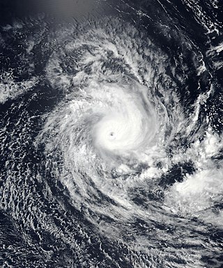
 Cyclone Ernie rapidly intensifying to the northwest of Western Australia on 7 April |
Tropical cyclones of the 2016–17 Australian region cyclone season | ||
|---|---|---|
 | ||
| Pre-1970s | |
|---|---|
| 1970s | |
| 1980s | |
| 1990s | |
| 2000s | |
| 2010s | |
| 2020s | |