Related Research Articles
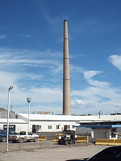
Hayden Smelter is a copper smelter at Hayden, Arizona, owned and operated by ASARCO. It has a 305 meters tall chimney, which is the tallest free-standing structure of Arizona.

Lamèque Island is a Canadian island in the Gulf of St. Lawrence at the northeastern tip of Gloucester County, New Brunswick.
KRDE is a radio station licensed to San Carlos, Arizona, United States. The station broadcasts a country format branded as "94.1 The Ride".

The Phoenix Air Defense Sector (PhADS) is an inactive United States Air Force organization. Its last assignment was with the Air Defense Command 28th Air Division, being stationed at Luke Air Force Base, Arizona. It was inactivated on 1 April 1966

Bouti Sayah is a town and commune in M'Sila Province, Algeria. According to the 1998 census it has a population of 7,806.
Price Mill is an unincorporated community located in Brunswick County, in the U.S. state of Virginia.
Lucks is an unincorporated community in Pittsylvania County, in the U.S. state of Virginia.

Mount Lemmon Air Force Station is a closed United States Air Force General Surveillance Radar station. It is located 17.2 miles (27.7 km) north-northeast of Tucson, Arizona. It was closed in 1969.
Gila Community College (GCC) is the community college serving the Gila Community College District in Gila County, Arizona. It has three campuses:
- Gila Pueblo Campus, Globe, Arizona
- Payson Campus, Payson, Arizona
- San Carlos Campus, San Carlos, Arizona

Cedar Creek is a census-designated place in Gila County, Arizona, United States, on the Fort Apache Indian Reservation. Cedar Creek is located along Arizona State Route 73. The population in 2010 was 318.

Copper Hill is a census-designated place in Gila County, Arizona. Copper Hill is located near US Route 60, northeast of the city of Globe. The population as of the 2010 U.S. Census was 108.

Dripping Springs is a census-designated place in Gila County in the state of Arizona. Dripping Springs is located about 14 miles north of the town of Hayden on Arizona State Route 77. The population as of the 2010 U.S. Census was 235.
Elysville is an unincorporated community in Howard County, Maryland, United States. A postal stop operated between February 22, 1834, and February 3, 1854.
Canyon Creek is a 48-mile (77 km) tributary of the Salt River in central Arizona. Originating on the Mogollon Rim, the creek flows generally south to its confluence with the Salt in the Salt River Canyon Wilderness, about 16 miles (26 km) above Theodore Roosevelt Lake.
Negro Wash is a stream in Gila County, Arizona, in the United States.
The Mescal Mountains are a series of connected mountain ridges in southern Gila County, Arizona. Their highest point is El Capitan Mountain, which has an elevation of 6,568 ft and a prominence of 1,828 ft. The highest point has a topographic isolation of 5.98 miles, with the nearest point of equal or greater elevation being to the north west in the Pinal Mountains. The mountain ridges are visible in the east from Arizona State Route 77 between Globe and Winkelman.The range is approximately 10 miles west of San Carlos Lake, which lies in the San Carlos Apache Indian Reservation; the ridges themselves also mostly fall within the boundary of the reservation, with the exception of the western section and the high point. As such, hiking the ridge may require special permission from San Carlos Apache Indian Reservation, although no trails exist on the mountains themselves or leading to them. The ridge's relative proximity to the more visually dominant Pinal Mountains, make it an often-overlooked feature. The range is one of many to occur in the Arizona transition zone.
The Sevenmile Mountains are a mountain range in central Gila County in the U.S. state of Arizona. The range has a maximum elevation of 6,629 ft (2,021 m) and a prominence of 989 ft (301 m). The highest peak is labelled Seven on the USGS topo sheet and has a topographic isolation of 13.35 miles. The majority of the southern end of the range is located on the San Carlos Apache Indian Reservation. The high point and the northwestern tip of the range is in the Tonto National Forest and is open to free range hiking. The mountains' high point is located just 3 miles east from a section of the U.S. Route 60 in Arizona in between Globe, Arizona and Show Low, Arizona. The southern end of the range that is inside the San Carlos Apache Indian Reservation should only be hiked with permission from the Reservation. The range is one of many that occur in the Arizona transition zone.

The Blackjack Mountains are a mountain range located in Gila County, Arizona. They have a maximum elevation of 6,942 ft (2,116 m) at Apache Peaks and a prominence of 2,580 ft (790 m). The peak has a topographic isolation of 17.88 miles, with the nearest higher peak lying to the south in the Pinal Mountains. The Blackjack mountains are located within the Tonto National Forest and are north of Globe, Arizona. The high point of the range, Apache Peaks, is ranked 36th in prominence for Arizona's most prominent peaks.
KHVL is an AM radio station, paired with two FM relay translators. Licensed to Huntsville, Texas, 1490 KHVL & 104.9 K285GE primarily serve Huntsville and the surrounding Walker County rural areas. 94.1 K231DA relays KHVL's programming to extend the signal into Willis, Panorama Village, and Lake Conroe. The station's branding is The Hits and broadcasts a Classic Hits format.
Odessadale is an unincorporated community in Meriwether County, in the U.S. state of Georgia.
References

Coordinates: 33°41′40″N110°48′47″W / 33.69444°N 110.81306°W
| This Gila County, Arizona location article is a stub. You can help Wikipedia by expanding it. |