Darwin City, Northern Territory

Last updated

Darwin City
Darwin,  Northern Territory
Darwin Panorama.jpg
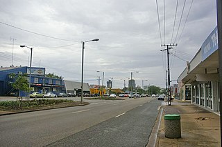
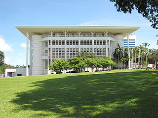
View of Darwin CBD from the Stuart Highway
Australia Northern Territory location map blank.svg
Red pog.svg
Darwin City
Coordinates 12°27′39″S130°50′40″E / 12.460834°S 130.844442°E / -12.460834; 130.844442 Coordinates: 12°27′39″S130°50′40″E / 12.460834°S 130.844442°E / -12.460834; 130.844442 [1]
Population6,464 (2016 census) [2]
Established1869
Postcode(s) 0800
LGA(s)
Territory electorate(s) Port Darwin
Federal Division(s) Division of Solomon
Suburbs around Darwin City:
The Gardens The Gardens
Stuart Park
Charles Darwin
Larrakeyah Darwin City Darwin Harbour
Darwin Harbour Darwin Harbour Darwin Harbour
FootnotesAdjoining suburbs [4] [5]

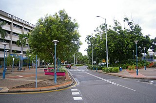
Darwin City (referred to as Darwin city centre or The CBD (Central Business District) is a suburb in metropolitan Darwin which comprises the original settlement, the central business district, parkland and other built-up areas. It is the oldest part of Darwin and includes many of the city's important institutions and landmarks, such as Parliament, Government House, the Northern Territory Supreme Court, Bicentennial Park and the George Brown Darwin Botanic Gardens. The city centre is located in the local government areas of the City of Darwin and the Darwin Waterfront Precinct. [3]

Darwin, Northern Territory City in the Northern Territory, Australia

Darwin is the capital city of the Northern Territory of Australia, situated on the Timor Sea. It is the largest city in the sparsely populated Northern Territory, with a population of 148,564. It is the smallest, wettest and most northerly of the Australian capital cities, and acts as the Top End's regional centre.

Parliament House, Darwin house of parliament for the Norther Territory, Australia

Parliament House in Darwin is Australia's newest Parliament Building, it has been the seat of the Northern Territory Legislative Assembly since 1994. Parliament House is located on State Square in the centre of Darwin, which is also the administrative centre of the Northern Territory law and government. It features Post modern features. The Northern Territory Library is housed in Parliament House. Construction of Parliament House began in 1990, and the building was completed in 1994, and officially opened by the Governor-General of Australia, Bill Hayden on 18 August 1994. Before Parliament House the former Northern Territory Legislative Council established in 1948 was housed in various temporary buildings around Darwin. After 1974 the Northern Territory Legislative Assembly continued to operate on the same basis, and settled in buildings on the current location until 1990 when they were demolished to allow commencement of the construction of Parliament House. From 1990 to the end of 1994, the Assembly temporarily met in the Chan Building.

Government House, Darwin building

Government House is the office and official residence of the Administrator of the Northern Territory. Built between 1870 and 1871, with later renovations between 1878 and 1879, the building is set on 13,000 square metres of hillside gardens in the centre of the Darwin business district, on The Esplanade.

Contents

Although the city centre is one of the most developed areas of Darwin, demographically it is one of the less densely populated, due to its core being commercial.

History

The first British person to see Darwin harbour appears to have been Lieutenant John Lort Stokes of HMS Beagle on 9 September 1839. The ship's captain, Commander John Clements Wickham, named the port after Charles Darwin, the British naturalist who had sailed with them both on the earlier second expedition of the Beagle.

United Kingdom Country in Europe

The United Kingdom of Great Britain and Northern Ireland, commonly known as the United Kingdom (UK) or Britain, is a sovereign country located off the north-western coast of the European mainland. The United Kingdom includes the island of Great Britain, the north-eastern part of the island of Ireland, and many smaller islands. Northern Ireland is the only part of the United Kingdom that shares a land border with another sovereign state, the Republic of Ireland. Apart from this land border, the United Kingdom is surrounded by the Atlantic Ocean, with the North Sea to the east, the English Channel to the south and the Celtic Sea to the south-west, giving it the 12th-longest coastline in the world. The Irish Sea separates Great Britain and Ireland. The United Kingdom's 242,500 square kilometres (93,600 sq mi) were home to an estimated 66.0 million inhabitants in 2017.

John Lort Stokes Welsh officer of the British Royal Navy, sailed with Charles Darwin

Admiral John Lort Stokes, RN was an officer in the Royal Navy who travelled on HMS Beagle for close to eighteen years.

HMS <i>Beagle</i> Cherokee-class 10-gun brig-sloop of the Royal Navy

HMS Beagle was a Cherokee-class 10-gun brig-sloop of the Royal Navy, one of more than 100 ships of this class. The vessel, constructed at a cost of £7,803, was launched on 11 May 1820 from the Woolwich Dockyard on the River Thames. In July of that year she took part in a fleet review celebrating the coronation of King George IV of the United Kingdom, and for that occasion is said to have been the first ship to sail completely under the old London Bridge. There was no immediate need for Beagle so she "lay in ordinary", moored afloat but without masts or rigging. She was then adapted as a survey barque and took part in three survey expeditions.

In the early 1870s, Darwin felt the effects of a gold rush at Pine Creek after employees of the Australian Overland Telegraph Line found gold while digging holes for telegraph poles.

Australian gold rushes

During the Australian gold rushes, significant numbers of workers relocated to areas in which gold had been discovered. A number of gold finds occurred in Australia prior to 1851, but only the gold found from 1851 onwards created gold rushes. This is mainly because, prior to 1851, the colonial government of New South Wales had suppressed news of gold finds which it believed would reduce the workforce and destabilise the economy.

Pine Creek, Northern Territory Town in the Northern Territory, Australia

Pine Creek is a small town in the Katherine region of the Northern Territory, Australia. As at the 2016 Census there were 328 residents of Pine Creek, which is the fourth largest town between Darwin and Alice Springs.

Australian Overland Telegraph Line Australian telecommunication circuit

The Australian Overland Telegraph Line was a 3200 km telegraph line that connected Darwin with Port Augusta in South Australia. Completed in 1872, the Overland Telegraph Line allowed fast communication between Australia and the rest of the world. An additional section was added in 1877 with the completion of the Western Australian section of the line. It was one of the great engineering feats of 19th-century Australia and probably the most significant milestone in Australia's telegraphic history.

On 5 February 1869, George Goyder, the Surveyor General of South Australia, established a small settlement of 135 people at Port Darwin. Goyder named the settlement Palmerston, after the British Prime Minister Lord Palmerston. In 1870, the first poles for the Overland Telegraph were erected in Darwin, connecting Australia to the rest of the world. The discovery of gold at Pine Creek in the 1880s further boosted the young territory's development. Upon Commonwealth administration in 1911, Darwin became the city's official name.

George Goyder Australian surveyor

George Woodroffe "Bud" "Little Energy" Goyder was a surveyor in the Colony of South Australia during the latter half of the nineteenth century.

The Surveyor General of South Australia is a position originally created for the colony of South Australia.

Prime Minister of the United Kingdom Head of UK Government

The Prime Minister of the United Kingdom, until 1801 known as the Prime Minister of Great Britain, is the head of government of the United Kingdom. The Prime Minister directs both the executive and the legislature, and, together with the Prime Minister's Cabinet,, is accountable to the Monarch, to Parliament, to the Prime Minister's political party and, ultimately, to the electorate for the policies and actions of the executive and the legislature.

Geography

The city centre is bordered by Daly Street to the north and extends east to the Stuart Highway McMinn Street to the east which borders Stuart Park. The border extends and east along Darwin Harbour it extends South the Darwin Waterfront and to the Darwin Convention Centre. It extends West along the Esplande and Bicentennial Park. [6]

Stuart Highway highway in the Northern Territory and South Australia

Stuart Highway is one of Australia's major highways. It runs from Darwin, Northern Territory, in the north, via Tennant Creek and Alice Springs, to Port Augusta, South Australia, in the south – a distance of 2,834 km (1,761 mi). Its northern and southern extremities are segments of Australia's Highway 1. The principal north-south route through the central interior of mainland Australia, the highway is often referred to simply as "The Track".

Stuart Park, Northern Territory Suburb of Darwin, the Northern Territory, Australia

Stuart Park is an inner suburb of the city of Darwin, Northern Territory, Australia.

Darwin Convention Centre

The Darwin Convention Centre is a convention centre located in Darwin, Northern Territory, Australia. Construction started on the convention centre in early 2006 and completed in June 2008, with the centre opening in July of that year. The convention centre is part of the $1.1 billion Darwin Waterfront Precinct project.

Demographics

According to the 2016 census of Population, there were 6,464 people in Darwin City.

The 2016 Australian census was the seventeenth national population census held in Australia. The census was officially conducted with effect on Tuesday, 9 August 2016. The total population of the Commonwealth of Australia was counted as 23,401,892 – an increase of 8.8 per cent or 1,894,175 people since the 2011 census. Norfolk Island joined the census for the first time in 2016, adding 1,748 to the population.

Related Research Articles

Palmerston, Northern Territory City in the Northern Territory, Australia

Palmerston is situated near Darwin Harbour and had a population of 33,695 at the 2016 census, making it the second largest city in the sparsely populated Northern Territory. Palmerston is a planned satellite city of Darwin, the capital and largest city in Australia's Northern Territory.

Darwin Harbour Body of water near Australia

Darwin Harbour is the body of water close to Darwin in the Northern Territory of Australia. It opens to the north at a line from Charles Point in the west to Lee Point in the east into the Beagle Gulf and connects via the Clarence Strait with the Van Diemen Gulf. It contains Port Darwin, which is flanked by Frances Bay to the east and Cullen Bay to the west.

Nightcliff, Northern Territory Suburb of Darwin, the Northern Territory, Australia

Nightcliff is a northern suburb of the city of Darwin, Northern Territory, Australia.

The history of Darwin details the city's growth from a fledgling settlement into a thriving colonial capital and finally a modern city.

The history of the Northern Territory began over 60,000 years ago when Indigenous Australians settled the region. Makassan traders began trading with the indigenous people of the Northern Territory for trepang from at least the 18th century onwards, and possibly 300 years prior to that.

Litchfield Municipality Local government area in the Northern Territory, Australia

The Litchfield Council is a local government area of the Northern Territory of Australia on the eastern and southeastern outskirts of the Darwin-Palmerston urban area. The municipality covers an area of 2,914.3 square kilometres (1,125.2 sq mi), and was created by the Northern Territory government on 6 September 1985.

Rapid Creek, Northern Territory Suburb of Darwin, the Northern Territory, Australia

Rapid Creek is a northern suburb of the city of Darwin, Northern Territory, Australia.

East Point, Northern Territory Suburb of Darwin, the Northern Territory, Australia

East Point is an inner northern suburb of the city of Darwin, Northern Territory of Australia.

Mitchell, Northern Territory Suburb of Darwin, the Northern Territory, Australia

Mitchell is a suburb in the Northern Territory of Australia located in the city of Palmerston about 18 kilometres (11 mi) south-east of Darwin City.

Southport, Northern Territory Suburb of Darwin, the Northern Territory, Australia

Southport is an outer rural locality in Darwin. It is based on the site of the abandoned Town of Southport, a thriving river port during the Pine Creek gold rush of the 1870s. It is located at the junction of the Blackmore and Darwin Rivers.

Beagle Gulf is a gulf in the Northern Territory of Australia which opens on its west side to the Timor Sea. The gulf is bounded to the south by the mainland and to the north by Bathurst and Melville Islands. It is connected to Van Diemen Gulf in the east by Clarence Strait. Its south coast includes the natural harbours of Darwin and Bynoe. It is approximately 100 km long and 50 km wide. It surrounds the Quail Island Group.

The Darwin Festival celebrates the multicultural aspects of the Northern Territory lifestyle. The Festival is held over 18 days in the dry season (May-Oct) and comprises a series of events including outdoor concerts, workshops, theatre, dance music, comedy, cabaret, film and visual arts. In 2020, Darwin Festival will be held from 6-23 August.

Stokes Hill Wharf

Stokes Hill Wharf is the main wharf for the city of Darwin in the Northern Territory of Australia and is named after Stokes Hill, which it sits beside. The hill itself was named after the previous commander of the HMS Beagle, Captain Pringle Stokes, by the current commander of the Beagle, John Clements Wickham in 1839.

Gilbert Rotherdale McMinn (1841-1924) surveyor and public servant

Gilbert Rotherdale McMinnCE, SM, was an Australian surveyor born in Ireland noted for his work in the Northern Territory surveying the Overland Telegraph Line. His middle name is occasionally spelt "Rutherdale".

Bynoe Harbour, Northern Territory Suburb of unincorporated area, the Northern Territory, Australia

Bynoe Harbour is a locality in the Northern Territory of Australia located about 41 kilometres (25 mi) south-west of the territory capital of Darwin.

Elrundie, Northern Territory Suburb of unincorporated area, the Northern Territory, Australia

Elrundie is a suburb in the Northern Territory of Australia located in Darwin about 13 kilometres (8.1 mi) east of Darwin City overlooking a part of Darwin Harbour known as the East Arm.

Richard Randall Knuckey Surveyor on the Overland Telegraph Line

Richard Randall Knuckey, often referred to as R.R. Knuckey and popularly known as Dick Knuckey, was a surveyor on the Overland Telegraph Line in central Australia from 1871 to 1872. He later became Chief Officer at the Electric Telegraph Department in Adelaide.

References

  1. "Place Names Register Extract for "Darwin City"". NT Place Names Register. Northern Territory Government. Retrieved 16 March 2019.
  2. 1 2 Australian Bureau of Statistics (27 June 2017). "Darwin City (State Suburb)". 2016 Census QuickStats. Retrieved 28 June 2017. OOjs UI icon edit-ltr-progressive.svg
  3. 1 2 "Annual Report 2006/2007" (PDF). Darwin Waterfront Corporation. 15 October 2007. p. 3. Retrieved 7 June 2019.
  4. "Darwin City Council Suburbs" (PDF). Place Names Committee. Northern Territory Government. Retrieved 16 March 2019.
  5. "Localities within (East Arm) Un-Incorporated area" (PDF). Place Names Committee. Northern Territory Government. Retrieved 16 March 2019.
  6. "City of Darwin streets and roads". Archived from the original on 24 May 2008. Retrieved 15 June 2008.