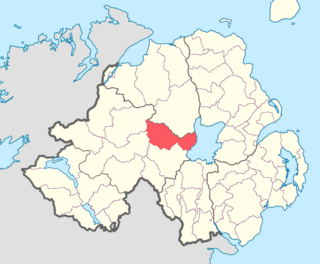
County Tyrone is one of the nine counties of Ulster, one of the six counties of Northern Ireland and one of the thirty-two counties on the island of Ireland. It is no longer used as an administrative division for local government but retains a strong identity in popular culture.
Cookstown is a town in County Tyrone, Northern Ireland. It is the fourth largest town in the county and had a population of 11,599 in the 2011 census. It, along with Magherafelt and Dungannon, is one the main towns in the Mid-Ulster council area. It was founded around 1620 when the townlands in the area were leased by an English ecclesiastical lawyer, Dr. Alan Cooke, from the Archbishop of Armagh, who had been granted the lands after the Flight of the Earls during the Plantation of Ulster. It was one of the main centres of the linen industry west of the River Bann, and until 1956, the processes of flax spinning, weaving, bleaching and beetling were carried out in the town.

Creggan is a townland in County Tyrone, Northern Ireland. It is situated in the historic barony of Omagh East and the civil parish of Termonmaguirk and covers an area of 4022 acres.

Coagh is a small village in County Tyrone, Northern Ireland, five miles (8 km) east of Cookstown. Part of the village also extends into County Londonderry. It had a population of 545 people in the 2001 Census. It owes its existence to George Butle Conyngham of Springhill, and was founded in 1728 when King George II of Great Britain granted Conyngham a market charter allowing the village to host four fairs yearly. It is situated within Mid-Ulster District.
Carrick is an Anglicised version of creag/carraig, Gaelic for "rock", and may refer to:
A registration district in the United Kingdom is a type of administrative region which exists for the purpose of civil registration of births, marriages, and deaths and civil partnerships. It has also been used as the basis for the collation of census information.
Tamlaght is a small village, townland and civil parish in County Londonderry, Northern Ireland. In the 2001 Census it had a population of 123 people. It is situated within Mid-Ulster District. The civil parish of Tamlaght covers areas of County Tyrone as well as County Londonderry.

Ardboe is a small village and civil parish in the north east of County Tyrone, Northern Ireland. It is near the western shore of Lough Neagh and lies within the Mid Ulster District Council area. It is also the name of the local civil parish, which also incorporates Moortown.
Ballinderry is a small civil and ecclesiastical parish on both sides of the County Londonderry / County Tyrone border in Northern Ireland. It is a rural parish of about 350 houses and lies on the western shores of Lough Neagh.
Ballylifford is a townland in County Londonderry, Northern Ireland. It is within the civil parish of Ballinderry, on the western shores of Lough Neagh, and is part of Mid-Ulster District. Many of the houses in the area have been built along Ballinderry Bridge Road.
Ballinderry may refer to:

Killyman is a small village and a civil parish in Northern Ireland, situated on the eastern boundary of County Tyrone and extending into County Armagh. The majority of townlands are in the historic barony of Dungannon Middle in County Tyrone, the rest being in the barony of Oneilland West in County Armagh.
Desertcreat is a parish and a townland in County Tyrone, Northern Ireland. The civil parish of Desertcreat is in the eastern part of County Tyrone in the barony Dungannon Upper, immediately south of the parish of Derryloran, which contains the town of Cookstown, and immediately north of the parish of Pomeroy. The parish has a Church of Ireland Church in the townland of Desertcreat. Patrick Donnelley, the Roman Catholic Bishop who was known as Phelim Brady or the 'Bard of Armagh', is buried in the church graveyard.
Dungannon Upper is a barony in County Tyrone, Northern Ireland. It was created in 1851 with the splitting of the barony of Dungannon. Lough Neagh runs along its eastern boundary, and it is bordered by four other baronies: Dungannon Middle to the south; Loughinsholin to the north; Strabane Upper to the north-west; and Omagh East to the south-west.

Favor Royal Demesne, also spelled Favour Royal, is a townland in County Tyrone, Northern Ireland. It is situated in the barony of Clogher and the civil parish of Errigal-Trough, adjacent to the Irish border. The townland covers an area of 670 acres (270 ha).
Gortalowry is a townland in County Tyrone, Northern Ireland. It is situated in the barony of Dungannon Upper and the civil parish of Derryloran and covers an area of 281 acres. The townland is partly rural, but includes the southern part of the town of Cookstown.
