Driftwood, Pennsylvania

Last updated

Driftwood, Pennsylvania
Pennsylvania State Route 555.jpg
View of westbound PA 555 from PA 120 in Driftwood
Cameron County Pennsylvania Incorporated and Unincorporated areas Driftwood Highlighted.svg
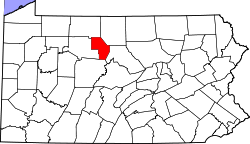
Location of Driftwood in Cameron County, Pennsylvania.
USA Pennsylvania location map.svg
Red pog.svg
Driftwood
Usa edcp location map.svg
Red pog.svg
Driftwood
Coordinates: 41°20′20″N78°08′08″W / 41.33889°N 78.13556°W / 41.33889; -78.13556
Country United States
State Pennsylvania
County Cameron
Settled1804
Incorporated (borough)1872
Area
[1]
  Total
2.56 sq mi (6.62 km2)
  Land2.49 sq mi (6.45 km2)
  Water0.07 sq mi (0.18 km2)
Elevation
850 ft (260 m)
Population
 (2020) [2]
  Total
38
  Density15.27/sq mi (5.89/km2)
Time zone Eastern (EST)
  Summer (DST)EDT
ZIP code
15832
Area code 814
FIPS code 42-19976

Driftwood is a borough in Cameron County, Pennsylvania, United States. The population was 36 at the 2020 census. [3]

Contents

History

The community takes its name from Driftwood Branch Sinnemahoning Creek (in older sources called "Driftwood Creek"). [4]

Geography

Driftwood is located in southern Cameron County at 41°20′20″N78°8′8″W / 41.33889°N 78.13556°W / 41.33889; -78.13556 (41.338836, -78.135535), [5] at the confluence of the Bennett Branch and the Driftwood Branch of Sinnemahoning Creek, an east-flowing tributary of the West Branch Susquehanna River. The community is at the bottom of a gorge carved 1,200 feet (370 m) deep or more into the Allegheny Plateau by the creek and its branches.

Pennsylvania Route 120 passes through Driftwood, following the Driftwood Branch north (upstream) 18 miles (29 km) to Emporium, the Cameron County seat, and following Sinnemahoning Creek and the West Branch of the Susquehanna east (downstream) 27 miles (43 km) to Renovo. Pennsylvania Route 555 leads west from Driftwood up the Bennett Branch 25 miles (40 km) to Weedville.

According to the United States Census Bureau, the borough of Driftwood has a total area of 2.5 square miles (6.6 km2), of which 2.5 square miles (6.4 km2) is land and 0.08 square miles (0.2 km2), or 2.66%, is water. [6]

Demographics

Historical population
CensusPop.Note
1880 504
1890 62824.6%
1900 509−18.9%
1910 5171.6%
1920 478−7.5%
1930 282−41.0%
1940 2933.9%
1950 289−1.4%
1960 203−29.8%
1970 184−9.4%
1980 163−11.4%
1990 116−28.8%
2000 103−11.2%
2010 67−35.0%
2020 36−46.3%
2021 (est.)36 [3] 0.0%
Sources: [7] [8] [9] [2]

2000 census

As of the census [8] of 2000, there were 103 people, 49 households, and 27 families residing in the borough. The population density was 57.5 inhabitants per square mile (22.2/km2). There were 88 housing units at an average density of 49.1 per square mile (19.0/km2). The racial makeup of the borough was 100.00% White.

There were 49 households, out of which 18.4% had children under the age of 18 living with them, 49.0% were married couples living together, 6.1% had a female householder with no husband present, and 42.9% were non-families. 36.7% of all households were made up of individuals, and 16.3% had someone living alone who was 65 years of age or older. The average household size was 2.10 and the average family size was 2.82.

In the borough the population was spread out, with 19.4% under the age of 18, 5.8% from 18 to 24, 26.2% from 25 to 44, 29.1% from 45 to 64, and 19.4% who were 65 years of age or older. The median age was 44 years. For every 100 females there were 102.0 males. For every 100 females age 18 and over, there were 88.6 males.

The median income for a household in the borough was $21,458, and the median income for a family was $44,167. Males had a median income of $32,250 versus $28,333 for females. The per capita income for the borough was $16,708. There were no families and 8.9% of the population living below the poverty line, including no under eighteens and 33.3% of those over 64.

2010 census

As of the census [10] of 2010, there were 67 people, 35 households, and 19 families residing in the borough. The population density was 26.8 inhabitants per square mile (10.3/km2). There were 93 housing units at an average density of 37.2 per square mile (14.4/km2). The racial makeup of the borough was 94% White, 1.5% Black, and 4.5% two or more races.

There were 35 households, out of which 17.1% had children under the age of 18 living with them, 42.9% were married couples living together, 5.7% had a female householder with no husband present, and 45.7% were non-families. 40% of all households were made up of individuals, and 11.5% had someone living alone who was 65 years of age or older. The average household size was 1.91 and the average family size was 2.58.

In the borough the population was spread out, with 10.4% under the age of 18, 65.7% from 18 to 64, and 23.9% who were 65 years of age or older. The median age was 51.3 years.

The median income for a household in the borough was $45,417, and the median income for a family was $50,536. The per capita income for the borough was $22,060. There were 9.5% families and 9.8% of the population living below the poverty line, including none under eighteens and 10% of those over 64.

Notable people

Related Research Articles

<span class="mw-page-title-main">Atwood, Pennsylvania</span> Borough in Pennsylvania, United States

Atwood is a borough in Armstrong County, Pennsylvania, United States. The population was 112 at the 2020 census.

<span class="mw-page-title-main">Emporium, Pennsylvania</span> Borough in Pennsylvania, United States

Emporium is a borough and the county seat of Cameron County in the U.S. state of Pennsylvania. It is located 100 miles (160 km) west-northwest of Williamsport. Early in the twentieth century, there were large power plants and manufacturers of radio tubes and incandescent lamps, paving brick, flour, iron, lumber, and sole leather. In 1900, 2,463 people lived in Emporium, and in 1910, the population was 2,916. By 2010, the population had dropped to 2,073, and at the 2020 census, the population was 1,961.

<span class="mw-page-title-main">Gibson Township, Cameron County, Pennsylvania</span> Township in Pennsylvania, United States

Gibson Township is a township in Cameron County, Pennsylvania, United States. The population was 178 at the 2020 census, up from 164 in 2010, which in turn was a decline from the figure of 222 in 2000.

<span class="mw-page-title-main">Grove Township, Cameron County, Pennsylvania</span> Township in Pennsylvania, United States

Grove Township is a township in Cameron County, Pennsylvania, United States. The population was 183 at the 2010 census, up from 129 in 2000.

<span class="mw-page-title-main">Lumber Township, Pennsylvania</span> Township in Pennsylvania, United States

Lumber Township is a township in Cameron County, Pennsylvania, United States. The population was 178 at the 2020 census, down from 195 in 2010.

<span class="mw-page-title-main">Portage Township, Cameron County, Pennsylvania</span> Township in Pennsylvania, United States

Portage Township is a township in Cameron County, Pennsylvania, United States. The population was 163 at the 2020 census, down from 171 in 2010.

<span class="mw-page-title-main">Clarence, Pennsylvania</span> Census-designated place in Pennsylvania, United States

Clarence is a census-designated place (CDP) in Centre County, Pennsylvania, United States. It is part of the State College, Pennsylvania Metropolitan Statistical Area. The population was 626 at the 2010 census.

<span class="mw-page-title-main">Brisbin, Pennsylvania</span> Borough in Pennsylvania, United States

Brisbin is a borough in Clearfield County, Pennsylvania, United States. The population was 422 at the 2020 census.

<span class="mw-page-title-main">Coalport, Pennsylvania</span> Borough in Pennsylvania, United States

Coalport is a borough in Clearfield County, Pennsylvania, United States. The population was 425 at the 2020 census.

<span class="mw-page-title-main">Glen Hope, Pennsylvania</span> Borough in Pennsylvania, United States

Glen Hope is a borough in Clearfield County, Pennsylvania, United States. The population was 127 at the 2020 census.

<span class="mw-page-title-main">Irvona, Pennsylvania</span> Borough in Pennsylvania, United States

Irvona is a borough in Clearfield County, Pennsylvania, United States. The population was 549 at the 2020 census.

<span class="mw-page-title-main">Westover, Pennsylvania</span> Borough in Pennsylvania, United States

Westover is a borough in Clearfield County, Pennsylvania, United States. The population was 361 at the 2020 census.

<span class="mw-page-title-main">Beech Creek, Pennsylvania</span> Borough in Pennsylvania, United States

Beech Creek is a borough in Clinton County, Pennsylvania, United States. The population was 701 at the 2010 census. It is the setting for Fun Home, a 2006 graphic memoir by Alison Bechdel, who grew up there. Brittani Kline, winner of America's Next Top Model, Cycle 16, was born there.

<span class="mw-page-title-main">Briar Creek, Pennsylvania</span> Borough in Pennsylvania, United States

Briar Creek is a borough in Columbia County, Pennsylvania, United States. It is part of Northeastern Pennsylvania. The population was 597 at the 2020 census. It is part of the Bloomsburg-Berwick micropolitan area.

<span class="mw-page-title-main">Spartansburg, Pennsylvania</span> Borough in Pennsylvania, United States

Spartansburg is a borough in Crawford County, in northwestern Pennsylvania, United States. The population was 277 at the 2020 census, down from 305 at the 2010 census.

<span class="mw-page-title-main">Benezette Township, Pennsylvania</span> Township in Pennsylvania, United States

Benezette Township is a township in Elk County, Pennsylvania, United States. The population was 217 at the 2020 census, up from 207 in 2010.

<span class="mw-page-title-main">Jay Township, Elk County, Pennsylvania</span> Township in Pennsylvania, United States

Jay Township is a township in Elk County, Pennsylvania, United States. The population was 1,961 at the 2020 census, down from 2,072 in 2010.

<span class="mw-page-title-main">Petersburg, Pennsylvania</span> Borough in Pennsylvania, United States

Petersburg is a borough in Huntingdon County, Pennsylvania, United States. It was a stop on the former Pennsylvania Railroad Main Line between Tyrone and Huntingdon and the junction point for the Petersburg Branch. The population was 480 at the 2010 census.

<span class="mw-page-title-main">Three Springs, Pennsylvania</span> Borough in Pennsylvania, United States

Three Springs is a borough in Huntingdon County, Pennsylvania, United States. The population was 444 at the 2010 census.

<span class="mw-page-title-main">Tioga, Pennsylvania</span> Borough in Pennsylvania, United States

Tioga is a borough in Tioga County, Pennsylvania, United States. The population was 611 at the 2010 census. It is located north of Tioga and Hammond Lakes along the Tioga River.

References

  1. "ArcGIS REST Services Directory". United States Census Bureau. Retrieved October 12, 2022.
  2. 1 2 "Census Population API". United States Census Bureau. Retrieved October 12, 2022.
  3. 1 2 "City and Town Population Totals: 2020-2021". Census.gov. US Census Bureau. Retrieved July 17, 2022.
  4. Espenshade, Abraham Howry (1925). Pennsylvania Place Names. Evangelical Press. p. 294. ISBN   978-0-8063-0416-8.
  5. "US Gazetteer files: 2010, 2000, and 1990". United States Census Bureau. February 12, 2011. Retrieved April 23, 2011.
  6. "Geographic Identifiers: 2010 Demographic Profile Data (G001): Driftwood borough, Pennsylvania". U.S. Census Bureau, American Factfinder. Archived from the original on April 6, 2015. Retrieved March 31, 2015.
  7. "Census of Population and Housing". U.S. Census Bureau. Retrieved December 11, 2013.
  8. 1 2 "U.S. Census website". United States Census Bureau . Retrieved January 31, 2008.
  9. "Incorporated Places and Minor Civil Divisions Datasets: Subcounty Resident Population Estimates: April 1, 2010 to July 1, 2012". Population Estimates. U.S. Census Bureau. Archived from the original on June 11, 2013. Retrieved December 11, 2013.
  10. "U.S. Census website". United States Census Bureau . Retrieved May 14, 2011.