Du Pont, Georgia

Last updated

Du Pont, Georgia
Du Pont Town Hall.jpg
Du Pont Town Hall
Clinch County Georgia Incorporated and Unincorporated areas Du Pont Highlighted.svg
Location in Clinch County and the state of Georgia
Coordinates: 30°59.4′N82°52.3′W / 30.9900°N 82.8717°W / 30.9900; -82.8717
Country United States
State Georgia
County Clinch
Government
  Type Mayor-council government
  MayorJames Rawls [1]
Area
[2]
  Total
0.78 sq mi (2.03 km2)
  Land0.78 sq mi (2.03 km2)
  Water0.00 sq mi (0.00 km2)
Elevation
184 ft (56 m)
Population
 (2020)
  Total
134
  Density171.14/sq mi (66.10/km2)
Time zone UTC-5 (Eastern (EST))
  Summer (DST) UTC-4 (EDT)
ZIP code
31630
Area code 912
FIPS code 13-24796 [3]
GNIS feature ID0355562 [4]

Du Pont is a town in Clinch County, Georgia, United States. The population was 134 in 2020.

Contents

According to the 1916 History of Clinch County the town was first settled around 1856 as Lawton, on the route of the newly chartered Atlantic and Gulf Railroad. During the Civil War, a branch line from Lawton to Live Oak, Florida, was built to assist the movement of Confederate troops and supplies, but was not completed until 1865, when the war was nearly over. [5] The town was renamed in 1874 after J. P. A. DuPont, an early settler. [6] It was incorporated as a city in 1889.

Geography

Du Pont is located in northwestern Clinch County at 30°59.4′N82°52.3′W / 30.9900°N 82.8717°W / 30.9900; -82.8717 (30.9896, -82.8707). [7] U.S. Route 84 passes through the center of the town, leading east 8 miles (13 km) to Homerville, the county seat, and west 8 miles (13 km) to Stockton.

According to the United States Census Bureau, Du Pont has a total area of 0.8 square miles (2.1 km2), all of it land.

Demographics

Historical population
CensusPop.Note
1910 342
1920 38111.4%
1930 372−2.4%
1940 332−10.8%
1950 285−14.2%
1960 210−26.3%
1970 25220.0%
1980 2676.0%
1990 177−33.7%
2000 139−21.5%
2010 120−13.7%
2020 13411.7%
U.S. Decennial Census [8]
1850-1870 [9] 1870-1880 [10]
1890-1910 [11] 1920-1930 [12]
1940 [13] 1950 [14] 1960 [15]
1970 [16] 1980 [17] 1990 [18]
2000 [19] 2010 [20]

As of the census [3] of 2000, there were 139 people, 57 households, and 42 families residing in the town. By 2010, its population was 120, [21] and at the 2020 census, its population was 134.

Related Research Articles

<span class="mw-page-title-main">Clinch County, Georgia</span> County in Georgia, United States

Clinch County is a county located in the southeastern part of the U.S. state of Georgia. As of the 2020 census, the population was 6,749. The county seat is Homerville. The county was created on February 14, 1850, named in honor of Duncan Lamont Clinch.

<span class="mw-page-title-main">Allentown, Georgia</span> City in Georgia, United States

Allentown is a city in Bleckley, Laurens, Twiggs, and Wilkinson counties in the U.S. state of Georgia, primarily in Wilkinson County. As of the 2010 census, the city had a population of 169, down from 287 at the 2000 census. In 2020, its population was 195. The Twiggs County portion is part of the Macon metropolitan statistical area, while the Laurens County portion is part of the Dublin micropolitan statistical area. The remaining Wilkinson and Bleckley County portions are not part of any metropolitan or micropolitan area.

<span class="mw-page-title-main">Sardis, Georgia</span> City in Georgia, United States

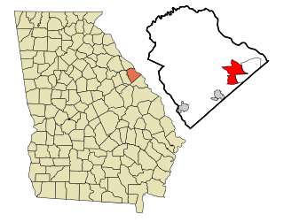
Sardis is a city in Burke County, Georgia, United States. The population is 995 in 2020. It is part of the Augusta, Georgia metropolitan area in the Central Savannah River Area (CSRA).

<span class="mw-page-title-main">Argyle, Georgia</span> Town in Georgia, United States

Argyle is a town in Clinch County, Georgia, United States. As of the 2020 census, the city had a population of 190.

<span class="mw-page-title-main">Fargo, Georgia</span> City in Georgia, United States

Fargo is a city in Clinch County, Georgia, United States. As of the 2020 census, the city had a population of 250. Formerly a town, it was incorporated by the Georgia state legislature in 1992, effective from April 1.

<span class="mw-page-title-main">Homerville, Georgia</span> City in Georgia, United States

Homerville is a city and the county seat of Clinch County, Georgia, United States. Its population was 2,456 at the 2010 census, a decrease of 12.38% from 2,803 in 2000. It was incorporated February 15, 1869.

<span class="mw-page-title-main">Evans, Georgia</span> Place in Georgia, United States

Evans is an unincorporated community and census-designated place (CDP) in Columbia County, Georgia, United States. It is a suburb of Augusta and is part of the Augusta metropolitan area. The population was 29,011 at the 2010 census, up from 17,727 at the 2000 census.

<span class="mw-page-title-main">Roberta, Georgia</span> City in Georgia, United States

Roberta is a city in Crawford County, Georgia, United States. The population was 1,007 at the 2010 census. It is part of the Macon metropolitan statistical area.

<span class="mw-page-title-main">Twin City, Georgia</span> City in Georgia, United States

Twin City is a city in Emanuel County, Georgia, United States. As of the 2020 census, the city had a population of 1,642.

<span class="mw-page-title-main">Wadley, Georgia</span> City in Georgia, United States

Wadley is a city in Jefferson County, Georgia, United States. The population was 1,643 in 2020.

<span class="mw-page-title-main">Wrens, Georgia</span> City in Georgia, United States

Wrens is a city in Jefferson County, Georgia, United States. The population was 2,217 at the 2020 census. It is located on U.S. Route 1, thirty miles west of Augusta.

<span class="mw-page-title-main">Millen, Georgia</span> City in Georgia, United States

Millen is a city, and the county seat of Jenkins County, Georgia, United States. The population was 3,120 at the 2010 census, down from 3,492 at the 2000 census.

<span class="mw-page-title-main">Wrightsville, Georgia</span> City in Georgia, United States

Wrightsville is a city in and the county seat of Johnson County, Georgia, United States. The population was 2,195 at the 2010 census, down from 2,223 at the 2000 census. By 2020, its population grew to 3,449. The city limits include Johnson State Prison on the northeast side of town. Wrightsville is part of the Dublin Micropolitan Statistical Area.

<span class="mw-page-title-main">Thomson, Georgia</span> City in Georgia, United States

Thomson is a city and the county seat of McDuffie County, Georgia, United States. The population was 6,814 at the 2020 census. Thomson's nickname is "The Camellia City of the South", in honor of the thousands of camellia plants throughout the city. Thomson was founded in 1837 as a depot on the Georgia Railroad. It was renamed in 1853 for railroad official John Edgar Thomson and incorporated February 15, 1854 as a town and in 1870 as a city. It is part of the Augusta – Richmond County Metropolitan Statistical Area.

<span class="mw-page-title-main">Iron City, Georgia</span> Town in Georgia, United States

Iron City is a town in Seminole County, Georgia, United States. The population was 312 in 2020.

<span class="mw-page-title-main">Bronwood, Georgia</span> Town in Georgia, United States

Bronwood is a town in Terrell County, Georgia, United States. As of the 2020 census, the city had a population of 334. It is part of the Albany, Georgia metropolitan statistical area.

<span class="mw-page-title-main">Soperton, Georgia</span> City in Georgia, United States

Soperton is a city in Treutlen County, Georgia, United States. The population was 2,889 in 2020. The city is the county seat of Treutlen County.

<span class="mw-page-title-main">Warrenton, Georgia</span> City in Georgia, United States

Warrenton is a city and the county seat of Warren County, Georgia, United States. The population was 1,744 in 2020.

<span class="mw-page-title-main">Tennille, Georgia</span> City in Georgia, United States

Tennille is a city in Washington County, Georgia, United States. The population was 1,469 in 2020.

<span class="mw-page-title-main">Alamo, Georgia</span> Town in Georgia, United States

Alamo is a town in Wheeler County, Georgia, United States. As of the 2020 census, the town had a population of 771. The town is the county seat of Wheeler County.

References

  1. "DUPONT". Georgia Municipal Association. Retrieved December 18, 2024.
  2. "2020 U.S. Gazetteer Files". United States Census Bureau. Retrieved December 18, 2021.
  3. 1 2 "U.S. Census website". United States Census Bureau . Retrieved January 31, 2008.
  4. "US Board on Geographic Names". United States Geological Survey. October 25, 2007. Retrieved January 31, 2008.
  5. "Atlantic & Gulf Railroad". Georgia's Railroad History and Heritage. Retrieved February 23, 2018.
  6. Krakow, Kenneth K. (1975). Georgia Place-Names: Their History and Origins (PDF). Macon, GA: Winship Press. p. 66. ISBN   0-915430-00-2.
  7. "US Gazetteer files: 2010, 2000, and 1990". United States Census Bureau. February 12, 2011. Retrieved April 23, 2011.
  8. "Decennial Census of Population and Housing by Decade". United States Census Bureau.
  9. "1870 Census of Population - Georgia - Population of Civil Divisions less than Counties" (PDF). United States Census Bureau. 1870.
  10. "1880 Census of Population - Georgia - Population of Civil Divisions less than Counties" (PDF). United States Census Bureau. 1880.
  11. "1910 Census of Population - Georgia" (PDF). United States Census Bureau. 1910.
  12. "1930 Census of Population - Georgia" (PDF). United States Census Bureau. 1930. pp. 251–256.
  13. "1940 Census of Population - Georgia" (PDF). United States Census Bureau. 1940.
  14. "1950 Census of Population - Georgia" (PDF). United States Census Bureau. 1950.
  15. "1960 Census of Population - Population of County Subdivisions - Georgia" (PDF). United States Census Bureau. 1960.
  16. "1970 Census of Population - Population of County Subdivisions - Georgia" (PDF). United States Census Bureau. 1970.
  17. "1980 Census of Population - Number of Inhabitants - Georgia" (PDF). United States Census Bureau. 1980.
  18. "1990 Census of Population - Summary Social, Economic, and Housing Characteristics - Georgia" (PDF). United States Census Bureau. 1990.
  19. "2000 Census of Population - General Population Characteristics - Georgia" (PDF). United States Census Bureau. 2000.
  20. "2010 Census of Population - General Population Characteristics - Georgia" (PDF). United States Census Bureau. 2010.
  21. "Geographic Identifiers: 2010 Demographic Profile Data (G001): Du Pont town, Georgia". U.S. Census Bureau, American Factfinder. Archived from the original on February 12, 2020. Retrieved July 29, 2014.