Northern Pakistan is a tourism region in northern and north-western parts of Pakistan, comprising the administrative units of Gilgit-Baltistan, Azad Kashmir, Khyber Pakhtunkhwa, Islamabad Capital Territory and the Rawalpindi Division in Punjab. The first two territories are a part of the wider Kashmir region. It is a mountainous region straddling the Himalayas, Karakoram and the Hindu Kush mountain ranges, containing many of the highest peaks in the world and some of the longest glaciers outside polar regions. Northern Pakistan accounts for a high level of Pakistan's tourism industry.

Saiful Muluk is a mountainous lake in northern Pakistan, located at the northern end of the Kaghan Valley, near the town of Naran in the Saiful Muluk National Park. At an elevation of 3,224 m above sea level, the lake is located above the tree line, and is one of the highest lakes in Pakistan.
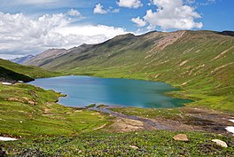
Lulusar, , or Lalusar, is a group of mountain peaks and a lake in the Kaghan Valley in the Khyber-Pakhtunkhwa province of Pakistan.
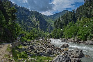
The Kunhar River or River Kunhar, is a 177 kilometres (110 mi) long river, located primarily in the Khyber Pakhtunkhwa province, northern Pakistan. It is in the Indus River watershed basin.

Ansoo Lake,, translated as Teardrop Lake, is situated in the Kaghan Valley of Khyber Pakhtunkhwa.
Payee Lake is situated in centre of meadow in Payee, near Shogran in Kaghan Valley, Khyber Pakhtunkhwa the province of Pakistan. It is located at the height of almost 2,895 metres (9,498 ft). It is surrounded by Makra Peak, Malika Parbat, Musa ka Musala and the mountains of Kashmir.The lake is accessible via Kiwai passing through Shogran by a jeep track. There is a problem in breathing there due to elevation.
Tourism in Pakistan is a growing industry. In 2010, Lonely Planet termed Pakistan "tourism's 'next big thing'". The country is geographically and ethnically diverse, and has a number of historical and cultural heritage sites. Condé Nast Traveller ranked Pakistan The Best Holiday Destination for 2020 and also declared it the third-highest potential adventure destination in the world for 2020. As security in the country improves, tourism increases; in two years, it has increased by more than 300%.

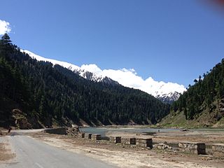
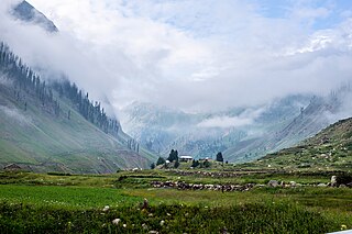
Shogran is a hill station situated on a plateau in the Kaghan Valley of Mansehra District, Khyber Pakhtunkhwa in northern Pakistan at a height of 2,362 metres (7,749 ft) above sea level. It has been a popular tourist attraction in recent years.

Kundol Lake, also known as Kundol Dand and Kundal, is a lake in the Swat Valley of Khyber Pakhtunkhwa, Pakistan. It is located in the north of the Utror Valley. It is 19 kilometres (12 mi) away from the Kalam Valley.
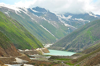
Naran is a town and popular tourist destination in the upper Kaghan Valley in the Mansehra District of the Khyber Pakhtunkhwa province of Pakistan. It is located 119 kilometers (74 mi) from Mansehra city at an altitude of 2,409 meters (7,904 ft). It is located about 65 kilometers (40 mi) away from Babusar Top. It is one of the most popular tourist attractions locally as well as internationally. Naran Valley is also Pakistan's most visited Valley, around 1.5 million people visit Naran Valley every year.
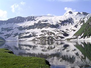
Lulusar-Dodipat National Park is located in the Kaghan Valley in Mansehra District of Khyber-Pakhtunkhwa, Pakistan. The park was created in 2003. The scenic Dudipatsar Lake and Lulusar Lake and peaks are in the park.
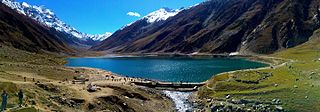
Saiful Muluk National Park is situated in the Kaghan Valley within the Mansehra District of Khyber Pakhtunkhwa, Pakistan. The park was officially declared in 2003, and is centred upon the alpine Saiful Muluk Lake.

Lalazar, is a tourist spot at an elevation of 3,123 metres (10,246 ft) above the sea level, located in upper Kaghan Valley in Mansehra District of Khyber Pakhtunkhwa Province of Pakistan.

The Dudipatsar Trail is an approximately 18 km (11 mi) hiking trail in the Lulusar-Dudipatsar National Park of Khyber-Pakhtunkhwa, in northern Pakistan. The trail goes along a tributary of the Kunhar River called Poorbi Narr in the northern Kaghan Valley. The headwater for the particular tributary is the Dudipat Lake and the trail has a cumulative elevation gain of 640 metres (2,100 ft). The average time taken to complete the trail is 5 to 8 hours.
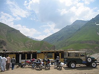
Besal is a small village located in Kaghan Valley, Mansehra District of Khyber Pakhtunkhwa province of Pakistan. It sits 3260 meters above sea level. It is adjacent to the Kunhar River, about 45 kilometers north of Naran. It is the starting point for hiking trails like Dudipatsar Trail. It is accessible by cars and motorbikes.
Saiful is a given name. Notable people with the name include:
Dharamsar is an alpine lake in the Kaghan Valley in the Khyber-Pakhtunkhwa province of Pakistan. It is located approximately 4,100 meters above sea level to the left of Babusar Top going eastwards from Chilas on the Karakoram Highway, next to the larger Sambaksar and Ganai Gali. Dharamsar lake is located close to the border of Khyber Pakhtunkhwa and Azad Jammu and Kashmir just south of the meeting point of all three of Khyber Pakhtunkhwa, Azad Kashmir and Gilgit-Baltistan.
Batakundi or Battakundi is a tourist town located 15 km east of Naran in Mansehra District, Khyber Pakhtunkhwa, Pakistan. It is located in the Kaghan Valley.
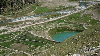
Pyala Lake is a round lake in Jalkhand, Kaghan Valley, Mansehra District of Khyber Pakhtunkhwa. It is about 40 kilometres (25 mi) from Naran.