Dungannon, Columbiana County, Ohio

Last updated

Dungannon, Ohio
St. Philip Neri (Dungannon, Ohio) 2012-07-14.JPG
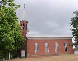
St. Philip Neri Catholic Church
USA Ohio relief location map.svg
Red pog.svg
Dungannon
Usa edcp relief location map.png
Red pog.svg
Dungannon
Coordinates: 40°44′03″N80°52′43″W / 40.73417°N 80.87861°W / 40.73417; -80.87861
Country United States
State Ohio
County Columbiana
Township Hanover
Elevation
[1]
1,122 ft (342 m)
Time zone UTC-5 (Eastern (EST))
  Summer (DST) UTC-4 (EDT)
ZIP code
44423
Area code(s) 330, 234
GNIS Feature ID 1064567 [1]

Dungannon is an unincorporated community in Hanover Township, Columbiana County, Ohio, United States. [1]

History

Dungannon was laid out in 1835 by George Sloan when the Sandy and Beaver Canal was extended to that point. He named the community after Dungannon, Northern Ireland, his native home. [2]

A post office was established at Dungannon in 1840, and remained in operation until it was discontinued in 1903. [3] The post office was originally spelt "Dunganon" before being changed to the current spelling of "Dungannon" in 1871. [4]

Related Research Articles

<span class="mw-page-title-main">Damascus, Ohio</span> Census-designated place in Ohio, United States

Damascus is an unincorporated community and census-designated place in southern Mahoning and northern Columbiana counties in the U.S. state of Ohio. As of the 2020 census, it had a population of 418. The community lies at the intersection of U.S. Route 62 and State Routes 173 and 534.

Winona is an unincorporated community in southeastern Butler Township, Columbiana County, Ohio, United States. It has a post office with the ZIP code 44493.

<span class="mw-page-title-main">North Georgetown, Ohio</span>

North Georgetown is an unincorporated community in western Knox Township, Columbiana County, Ohio, United States. Although unincorporated, it has a post office, with the ZIP code of 44665. The town itself is located at the intersection of Georgetown Road and Rochester Road.

<span class="mw-page-title-main">Kensington, Ohio</span> Unincorporated community in Ohio, United States

Kensington is an unincorporated community in southwestern Hanover Township, Columbiana County, Ohio, United States. Lying along U.S. Route 30 at its intersection with Ohio State Routes 9 and 644, it has a post office with the ZIP code 44427. Kensington is a part of the Salem micropolitan area, 23 miles (37 km) miles east of Canton and 30 miles (48 km) southwest of Youngstown.

<span class="mw-page-title-main">Fredericktown, Columbiana County, Ohio</span> Unincorporated community in Ohio, United States

Fredericktown is a historic unincorporated community at the confluence of the north and middle forks of Little Beaver Creek in northeastern St. Clair Township, Columbiana County, Ohio, United States. It lies about six miles north of nearby East Liverpool and about 50 miles west of Pittsburgh. It is known for its historic buildings and its natural environment.

Williamsport is an unincorporated community in northwestern Madison Township, Columbiana County, Ohio, United States.

Cannons Mill is an unincorporated community in Columbiana County, in the U.S. state of Ohio.

Chambersburg is an unincorporated community in Columbiana County, in the U.S. state of Ohio.

Franklin Square is an unincorporated community in central Salem Township, Columbiana County, Ohio, United States.

Gavers is an unincorporated community in Columbiana County, in the U.S. state of Ohio.

Glasgow is an unincorporated community in Columbiana County, in the U.S. state of Ohio.

<span class="mw-page-title-main">Highlandtown, Ohio</span> Unincorporated community in Ohio, United States

Highlandtown is an unincorporated community in eastern Washington Township, Columbiana County, Ohio, United States. It is immediately south of Highlandtown Lake, a reservoir which takes its name.

Lynchburg is an unincorporated community in Columbiana County, in the U.S. state of Ohio.

Middleton is an unincorporated community in Columbiana County, in the U.S. state of Ohio.

Mill Rock is an unincorporated community in Columbiana County, in the U.S. state of Ohio.

Millport is an unincorporated community in Franklin Township, Columbiana County, Ohio, United States. It lies just north of the village of Summitville in the southwestern part of the county, at the intersection of Ohio State Route 644 and 518.

Moultrie is an unincorporated community in Columbiana County, in the U.S. state of Ohio.

Teegarden is an unincorporated community in Columbiana County, in the U.S. state of Ohio.

Unity is an unincorporated community in Unity Township, Columbiana County, Ohio, United States. It lies north of East Palestine at the confluence of Ohio State Routes 14, 165, and 170.

Valley is an unincorporated community in Butler Township, Columbiana County, Ohio, United States. It lies about 2.5 miles (4.0 km) south of Damascus and 6 miles (9.7 km) southwest of Salem.

References

  1. 1 2 3 U.S. Geological Survey Geographic Names Information System: Dungannon, Columbiana County, Ohio
  2. Mack, Horace (1879). History of Columbiana County, Ohio: With Illustrations and Biographical Sketches of Some of Its Prominent Men and Pioneers. Unigraphic. p. 162.
  3. U.S. Geological Survey Geographic Names Information System: Dungannon Post Office (historical)
  4. "Ohio, Columbiana County". www.postalhistory.com. Jim Forte Postal History. Retrieved July 28, 2021.