East Fairfield, Ohio

Last updated

East Fairfield, Ohio
Nicholas Eckis House.jpg
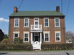
Nicholas Eckis House, built in 1833.
USA Ohio relief location map.svg
Red pog.svg
East Fairfield
Usa edcp relief location map.png
Red pog.svg
East Fairfield
Coordinates: 40°49′19″N80°38′10″W / 40.82194°N 80.63611°W / 40.82194; -80.63611
Country United States
State Ohio
County Columbiana
Township Fairfield
Elevation
[1]
1,230 ft (370 m)
Time zone UTC-5 (Eastern (EST))
  Summer (DST) UTC-4 (EDT)
ZIP code
44445
Area codes 234/330
GNIS feature ID1064579 [1]

East Fairfield is an unincorporated community in Fairfield Township, Columbiana County, Ohio, United States. [1] The community is located at the intersection of Ohio State Routes 7, 517, and 558.

History

East Fairfield was laid out in 1803. [2] With the construction of the railroad, business activity shifted away from inland East Fairfield, and the town's population dwindled. [3] A post office called East Fairfield was established in 1828, and remained in operation until 1906. [4] Today, it is home to a few small businesses, farms, as well as a church.

References

  1. 1 2 3 U.S. Geological Survey Geographic Names Information System: East Fairfield, Ohio
  2. McCord, William B. (1905). History of Columbiana County, Ohio and Representative Citizens. Biographical Publishing Company. p.  280.
  3. History of Columbiana County, Ohio: With Illustrations and Biographical Sketches of Some of Its Prominent Men and Pioneers. Unigraphic. 1879. p. 143.
  4. "Columbiana County". Jim Forte Postal History. Archived from the original on March 4, 2016. Retrieved January 10, 2016.