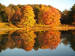
Lake Tomahawk, Ohio | |
---|---|
Motto: "A Piece of Paradise on Earth" | |
Coordinates: 40°45′50″N80°35′43″W / 40.76389°N 80.59528°W | |
Country | United States |
State | Ohio |
County | Columbiana |
Township | Middleton |
Area | |
• Total | 1.02 sq mi (2.65 km2) |
• Land | 0.83 sq mi (2.14 km2) |
• Water | 0.20 sq mi (0.51 km2) |
Elevation | 1,096 ft (334 m) |
Population (2020) | |
• Total | 494 |
• Density | 598.06/sq mi (230.90/km2) |
Time zone | UTC-5 (Eastern (EST)) |
• Summer (DST) | UTC-4 (EDT) |
ZIP code | 44441 |
Area code(s) | 330, 234 |
FIPS code | 39-41597 |
GNIS Feature ID | 2628921 [2] |
School District | Beaver Local School District |
Website | www |
Lake Tomahawk is an unincorporated community and census-designated place in central Middleton Township, Columbiana County, Ohio, United States. The population was 494 at the 2020 census. [3] It was established in 1966 by the American Realty Service Corporation as a private planned community surrounding the man-made Lake Tomahawk reservoir. [4]
Lake Tomahawk is 150-acre (61 ha) and is surrounded by 630 acres (250 ha) of residential homes and scenic property. It is a man-made, spring-fed lake, home to a variety of stocked fish. The average lake depth is 35 feet (11 m) with a maximum depth of 65 feet (20 m) at the dam. There is a 750-foot (230 m) beach with a picnic pavilion, a children's playground, and lighted tennis, volleyball and basketball courts. The community has a driving range and archery range. There are six docking areas with a total of 26 slips and a marina with a boat launching ramp and gasoline pump. With over 200 feet (61 m) of sandy beach, the lake is enjoyed by swimmers, boaters, waterskiers, and fishermen. [5]
According to the United States Census Bureau, the CDP has a total area of 0.8 square miles (2.07 km2). [6]
Lake Tomahawk has four distinct seasons, with precipitation somewhat evenly spread throughout the year. Extreme temperature variations occur during the winter only. Tomahawk usually has its wettest month during May and its warmest temperatures in late July and August.
The elevation of Lake Tomahawk is 1,135 feet (346 m) above sea level at its highest elevation (Lake Tomahawk Dam). [7]
Lake Tomahawk gets on average 37 inches (940 mm) of rain per year. Snowfall is 28 inches (710 mm). The number of days with any measurable precipitation is 130.
On average, there are 162 sunny days per year in Lake Tomahawk. The average July high is around 84 °F (29 °C). The January low is 18 °F (−8 °C). The comfort index, which is based on humidity during the hot months, is a 49 out of 100, where higher is more comfortable. The US average on the comfort index is 44.
Census | Pop. | Note | %± |
---|---|---|---|
2010 | 485 | — | |
2020 | 494 | 1.9% | |
U.S. Decennial Census [8] [9] |
This section needs expansion. You can help by adding to it. (March 2022) |
Lake Tomahawk is governed by a property owners association. Lake Tomahawk has a nine-member board, with three members elected every year. The board's responsibilities include the management of the lake, roads, marina, beach, treasury, security, legal, conservation and lake activities. Lake Tomahawk has its own private security force which patrols the lake and its grounds while enforcing lake regulations. [10]
Children in Lake Tomahawk are served by the Beaver Local School District. The current schools serving Lake Tomahawk are:
The City and Borough of Yakutat is a borough in the state of Alaska. Yakutat was also the name of a former city within the borough. The name in Tlingit is Yaakwdáat. It is derived from an Eyak name, diyaʼqudaʼt, and was influenced by the Tlingit word yaakw.
Bella Vista is a city in Benton County, Arkansas, United States. First established in 1917 as a summer resort destination, Bella Vista has evolved and redesigned itself over the succeeding years. Bella Vista became a retirement community in 1965, and, after much contention and a 2006 vote of its property owners, became an incorporated city.
Prairie Creek is a census-designated place (CDP) in Benton County, Arkansas, United States. Per the 2020 census, the population was 2,217. It is a lakefront community adjacent to Beaver Lake and Rogers within the Northwest Arkansas region.
Hot Springs Village is a census-designated place (CDP) in Garland and Saline counties in the U.S. state of Arkansas. As it is situated in two counties, it is also part of two metropolitan statistical areas. The portion in Garland County is within the Hot Springs Metropolitan Statistical Area, while the portion extending into Saline County is part of the Little Rock–North Little Rock–Conway Metropolitan Statistical Area. The population was 12,807 at the 2010 census. It is the largest gated community in the United States.
Muir Beach is a census designated place (CDP), unincorporated community, and beach on the Pacific Ocean. The community is located 16.5 miles (26.6 km) northwest of San Francisco in western Marin County, California, United States. Unlike many other entities in the area, it is not named directly in honor of conservationist John Muir; instead, it was named after Muir Woods National Monument to capitalize on the latter's popularity. The population was 304 at the 2020 census. The community itself flanks the northwest side of the beach.
Kings Beach is a census-designated place (CDP) in Placer County, California, United States, on the north shore of Lake Tahoe. The population was 3,563 at the 2020 census.
Beach Haven West is an unincorporated community and census-designated place (CDP) constituting a part of the Jersey Shore community of Stafford Township, in southern Ocean County, within the U.S. state of New Jersey. As of the 2020 United States census, the CDP's population was 4,143, an increase of 247 (+6.3%) from the 3,896 recorded at the 2010 census, which in turn had reflected a decrease of 548 (−12.3%) from the 4,444 counted in the 2000 census.
Calcutta is an unincorporated community and census-designated place in southeastern St. Clair Township, Columbiana County, Ohio, United States. The population was 3,941 at the 2020 census. Historically a rural town, Calcutta developed in the late 20th century as businesses from neighboring East Liverpool moved into larger shopping centers clustered around Ohio State Route 170.
Landen is a census-designated place (CDP) in Deerfield Township, Warren County, Ohio, United States. The population was 6,995 at the 2020 census. It is located around Columbia Road and Montgomery Road in the southeastern part of the township. It surrounds Twenty Mile Stand and near Fosters.
Pocono Pines is a census-designated place (CDP) in Monroe County, Pennsylvania. The population in the 2020 United States Census was 2,007, an increase over the 1,409 population at the 2010 census.
Lake Wylie is a census-designated place (CDP) in York County, South Carolina, United States. The population was 8,841 at the 2010 census. Lake Wylie is located on a peninsula along the shore of Lake Wylie, a reservoir that was named for Dr. W. Gil Wylie in 1960. It is a suburb of Charlotte, North Carolina.
Lake Barcroft is a census-designated place (CDP) in Fairfax County, Virginia, United States. The population was 9,558 at the 2010 census. It is also the name of the privately owned lake—part of the Cameron Run Watershed—around which this population is located. The lake is named for Dr. John W. Barcroft, who owned and operated a mill on Holmes Run during the mid-19th century.
Montclair is a census-designated place (CDP) in Prince William County, Virginia, United States. The population was 22,279 in the 2020 census. An affluent residential community surrounding a man-made lake and golf course, development began in the late 1960s and new home construction ended during the 1990s.
Beaver Dam is a city in Dodge County, Wisconsin, United States, along Beaver Dam Lake and the Beaver Dam River. The population was 16,708 at the 2020 census, making it the largest city primarily located in Dodge County. It is the principal city of the Beaver Dam Micropolitan Statistical area which is included in the larger Milwaukee–Waukesha–Racine CSA. The city is adjacent to the Town of Beaver Dam.
Pine Mountain Lake (PML) is a private gated community and a census-designated place (CDP) in Tuolumne County, California. It is located 0.8 miles (1.3 km) north and east of Groveland. Pine Mountain Lake sits at an elevation of 2,795 feet (852 m). The 2010 United States census reported Pine Mountain Lake's population was 2,796.
Beaver Dam is an unincorporated community and census-designated place (CDP) in Mohave County, Arizona, United States, that is located in the Arizona Strip region and was settled on December 2, 1863. It is located along Interstate 15 approximately 10 miles (16 km) northeast of Mesquite, Nevada. It is located in the 86432 ZIP Code. It had a population of 1,552 as of the 2020 census, a decline from the figure of 1,962 tabulated in 2010.
Lake Milton is a census-designated place in Milton Township, Mahoning County, Ohio, United States. The population was 637 at the 2020 census. The community sits along the shore of the Lake Milton reservoir along with the village of Craig Beach. It is part of the Youngstown–Warren metropolitan area.
Negley is an unincorporated community and census-designated place in Middleton Township, Columbiana County, Ohio, United States. The population was 274 at the 2020 census. Historically a mining community, it lies at the confluence of Bull Creek and the North Fork of the Little Beaver Creek at the state border with Pennsylvania. State Routes 154 and 170 as well as the Youngstown and Southeastern Railroad pass through the community.
Lake Holiday is an unincorporated community and census-designated place (CDP) in Union Township, Montgomery County, in the U.S. state of Indiana. It is a private community on the banks of its eponymous body of water. As of the 2020 census, the community had a population of 921 residents.
Hide-A-Way Hills is a census-designated place (CDP) in Fairfield and Hocking counties in the U.S. state of Ohio. As of the 2020 census, the community had a population of 976.