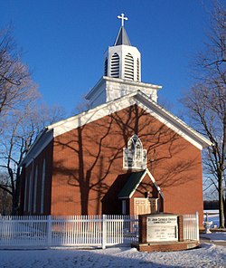
Summitville, Ohio | |
---|---|
Summitville Post Office | |
![]() Location of Summitville in Columbiana County, Ohio. | |
Coordinates: 40°40′33″N80°53′15″W / 40.67583°N 80.88750°W | |
Country | United States |
State | Ohio |
County | Columbiana |
Government | |
• Type | Mayor-Council |
• Mayor | Fred O. May [1] |
Area | |
• Total | 0.95 sq mi (2.46 km2) |
• Land | 0.92 sq mi (2.39 km2) |
• Water | 0.03 sq mi (0.07 km2) |
Elevation | 1,119 ft (341 m) |
Population (2020) | |
• Total | 110 |
• Density | 119.05/sq mi (45.95/km2) |
Time zone | UTC-5 (Eastern (EST)) |
• Summer (DST) | UTC-4 (EDT) |
ZIP code | 43962 |
Area code(s) | 330, 234 |
FIPS code | 39-75574 [4] |
GNIS feature ID | 2399931 [3] |
School District | Southern Local School District |
Summitville is a village in southwestern Columbiana County, Ohio, United States. The population was 110 at the 2020 census. [5]
Summitville was laid out in 1853. [6] The village was so named on account of its lofty elevation near one of the highest points between the Sandy Creek and Lake Erie. [7]
According to the United States Census Bureau, the village has a total area of 0.95 square miles (2.46 km2), of which 0.92 square miles (2.38 km2) is land and 0.03 square miles (0.08 km2) is water. [8] It is approximately 25 miles (40 km) miles southeast of Canton and 30 miles (48 km) southwest of Youngstown.
Census | Pop. | Note | %± |
---|---|---|---|
1950 | 150 | — | |
1960 | 144 | −4.0% | |
1970 | 143 | −0.7% | |
1980 | 146 | 2.1% | |
1990 | 125 | −14.4% | |
2000 | 108 | −13.6% | |
2010 | 135 | 25.0% | |
2020 | 110 | −18.5% | |
U.S. Decennial Census [9] |
As of the census [10] of 2010, there were 135 people, 51 households, and 39 families living in the village. The population density was 146.7 inhabitants per square mile (56.6/km2). There were 55 housing units at an average density of 59.8 per square mile (23.1/km2). The racial makeup of the village was 95.6% White, 0.7% African American, and 3.7% from two or more races. Hispanic or Latino of any race were 4.4% of the population.
There were 51 households, of which 33.3% had children under the age of 18 living with them, 64.7% were married couples living together, 5.9% had a female householder with no husband present, 5.9% had a male householder with no wife present, and 23.5% were non-families. 17.6% of all households were made up of individuals, and 11.7% had someone living alone who was 65 years of age or older. The average household size was 2.65 and the average family size was 3.00.
The median age in the village was 38.2 years. 25.9% of residents were under the age of 18; 6.7% were between the ages of 18 and 24; 24.4% were from 25 to 44; 23.7% were from 45 to 64; and 19.3% were 65 years of age or older. The gender makeup of the village was 50.4% male and 49.6% female.
As of the census [4] of 2000, there were 108 people, 45 households, and 31 families living in the village. The population density was 116.1 inhabitants per square mile (44.8/km2). There were 49 housing units at an average density of 52.7 per square mile (20.3/km2). The racial makeup of the village was 97.22% White, and 2.78% from two or more races. Hispanic or Latino of any race were 0.93% of the population.
There were 45 households, out of which 28.9% had children under the age of 18 living with them, 57.8% were married couples living together, 13.3% had a female householder with no husband present, and 28.9% were non-families. 26.7% of all households were made up of individuals, and 15.6% had someone living alone who was 65 years of age or older. The average household size was 2.40 and the average family size was 2.94.
In the village, the population was spread out, with 26.9% under the age of 18, 5.6% from 18 to 24, 25.9% from 25 to 44, 28.7% from 45 to 64, and 13.0% who were 65 years of age or older. The median age was 40 years. For every 100 females there were 74.2 males. For every 100 females age 18 and over, there were 68.1 males.
The median income for a household in the village was $26,250, and the median income for a family was $38,750. Males had a median income of $31,250 versus $17,143 for females. The per capita income for the village was $17,236. There were 13.3% of families and 15.7% of the population living below the poverty line, including 36.4% of under eighteens and none of those over 64.
Summitville operates under a mayor–council government, where there are six council members elected as a legislature in addition to an independently elected mayor who serves as an executive. [1] The current mayor is Fred O. May. [1] In addition, there is an elected village clerk and treasurer; the position was combined in 1998.
Children in Summitville are served by the Southern Local School District, which operates a K-12 complex in Washington Township. The renovated complex was built by adding to what was then the Southern Local High School building, and was completed in 2004. [11] At one time, Summitville was home to its own schoolhouse, Franklin Elementary School. The current schools serving the village are:
Columbiana County is a county located in the U.S. state of Ohio. As of the 2020 census, the population was 101,877. The county seat is Lisbon and its largest city is Salem. Created in 1803, the county name is derived from that of 15th-century Italian explorer Christopher Columbus.
Carroll County is a county located in the state of Ohio. As of the 2020 census, the population was 26,721. Its county seat is Carrollton, while its largest village is Minerva. It is named for Charles Carroll of Carrollton, the last surviving signer of the Declaration of Independence. Carroll County is part of the Canton-Massillon, OH Metropolitan Statistical Area, which is also included in the Cleveland-Akron-Canton, OH Combined Statistical Area. It is in the Appalachian Ohio region.
Summitville is a town in Van Buren Township, Madison County, Indiana, United States. It is part of the Indianapolis–Carmel–Anderson metropolitan statistical area. The population was 989 at the 2020 census.
Calcutta is an unincorporated community and census-designated place in St. Clair Township, Columbiana County, Ohio, United States. The population was 3,941 at the 2020 census. Historically a rural town, Calcutta developed in the late 20th century as businesses from neighboring East Liverpool moved into larger shopping centers clustered around Ohio State Route 170.
Glenmoor is an unincorporated community and census-designated place in southwestern St. Clair Township, Columbiana County, Ohio, United States. The population was 1,829 at the 2020 census.
Hanoverton is a village in western Columbiana County, Ohio, United States. The population was 354 at the 2020 census.
La Croft is an unincorporated community and census-designated place in Liverpool Township, Columbiana County, Ohio, United States. The population was 1,078 at the 2020 census.
Leetonia is a village in northern Columbiana County, Ohio, United States. The population was 1,833 at the 2020 census. It is about 15 miles (24 km) south of Youngstown.
New Waterford is a village in northeastern Columbiana County, Ohio, United States. The population was 1,194 at the 2020 census. It is about 20 miles (32 km) south of Youngstown.
Rogers is a village in eastern Columbiana County, Ohio, United States. The population was 194 at the 2020 census. It is best known for the Rogers Flea Market & Auctions, one of the largest open-air flea markets in Ohio.
Salineville is a village in southwestern Columbiana County, Ohio, United States. The population was 1,206 at the 2020 census.
Metamora is a village in Fulton County, Ohio, United States. The population was 566 at the 2020 census.
Hebron is a village in Licking County, Ohio, United States. The population was 2,326 at the 2020 census.
Beloit is a village in southwestern Mahoning County, Ohio, United States. The population was 903 at the 2020 census. It is part of the Youngstown–Warren metropolitan area.
Glenford is a village in Perry County, Ohio, United States. The population was 165 at the 2020 census.
Ottoville is a village in Monterey Township, Putnam County, Ohio, United States. The population was 966 at the 2020 census.
Limaville is a census-designated place (CDP) and former village in Stark County, Ohio, United States. The population was 151 at the 2020 census. It is part of the Canton–Massillon Metropolitan Statistical Area.
Columbiana is a city in northern Columbiana and southern Mahoning counties in the U.S. state of Ohio. The population was 6,559 at the 2020 census. It is part of the Youngstown–Warren metropolitan area.
Washingtonville is a village in northern Columbiana and southern Mahoning counties in the U.S. state of Ohio. The population was 712 at the 2020 census. It is part of the Youngstown–Warren metropolitan area.
Mogadore is a village in Portage and Summit counties in the U.S. state of Ohio. The population was 3,811 at the 2020 census. A suburb of Akron, it is part of the Akron metropolitan area.