Negley, Ohio | |
---|---|
Coordinates: 40°47′34″N80°32′09″W / 40.79278°N 80.53583°W | |
Country | United States |
State | Ohio |
County | Columbiana |
Township | Middleton |
Area | |
• Total | 0.90 sq mi (2.32 km2) |
• Land | 0.90 sq mi (2.32 km2) |
• Water | 0.00 sq mi (0.00 km2) |
Elevation | 856 ft (261 m) |
Population (2020) | |
• Total | 274 |
• Density | 305.80/sq mi (118.01/km2) |
Time zone | UTC-5 (Eastern (EST)) |
• Summer (DST) | UTC-4 (EDT) |
ZIP code | 44441 |
Area code(s) | 330, 234 |
FIPS code | 39-53802 |
GNIS feature ID | 2628937 [2] |
School District | East Palestine City School District |
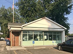
Negley is an unincorporated community and census-designated place in Middleton Township, Columbiana County, Ohio, United States. The population was 274 at the 2020 census. [3] Historically a mining community, it lies at the confluence of Bull Creek and the North Fork of the Little Beaver Creek at the state border with Pennsylvania. State Routes 154 and 170 as well as the Youngstown and Southeastern Railroad pass through the community.
Census | Pop. | Note | %± |
---|---|---|---|
2010 | 281 | — | |
2020 | 274 | −2.5% | |
U.S. Decennial Census [4] [5] |
Negley was the site of a Native American community before European colonization, located on a section of the Great Trail that “crossed the pancake” on the way between Pittsburgh, Pennsylvania and Coshocton, Ohio.[ citation needed ]
Negley derives its name from Civil War Major General James S. Negley, who hailed from Pittsburgh. After the end of the Civil War, Negley returned to Pittsburgh and served in the U.S. House of Representatives for Pennsylvania in the late 19th century. After retiring from politics, he entered the railroad business and became president of the New York, Pittsburgh & Chicago Railway, which in 1883 platted Negley as the first new town along its line, named in his honor. [6]
Negley grew into a small mining community based on a nearby coal mine operated by the Powers Mining Company. [7] The community formerly had an honor roll for residents who were veterans of World War II on the east side, but it was removed in the 1960s due to deterioration. [6] A Negley post office has been in operation since 1883, which serves eastern Middleton Township and Lake Tomahawk. It bears the ZIP code of 44441.
Negley was formerly home to the only Youngstown and Southern Railway shop. [8]
Negley is located in eastern Columbiana County in eastern Middleton Township, which it completely surrounded by. The CDP lies along of the North Fork of the Little Beaver Creek and Bull Creek at the foothills of the Appalachian Mountains. The CDP is 3 miles (4.8 km) south of East Palestine, 14 miles (23 km) north of East Liverpool, and 10 miles (16 km) west of central Chippewa Township, Pennsylvania.
The following highways pass through Negley:
According to the United States Census Bureau, the Negley CDP has a total area of 0.89 square miles (2.31 km2), all land. [3]
PennOhio Waste operates a construction and demolition debris landfill in Negley. [9]
Children in Negley are served by the East Palestine City School District. Negley once had a traditional schoolhouse of its own, and later an elementary school. The current schools serving Negley are:
Columbiana County is a county located in the U.S. state of Ohio. As of the 2020 census, the population was 101,877. The county seat is Lisbon and its largest city is Salem. Created in 1803, the county name is derived from that of 15th-century Italian explorer Christopher Columbus.
Calcutta is an unincorporated community and census-designated place in southeastern St. Clair Township, Columbiana County, Ohio, United States. The population was 3,941 at the 2020 census. Historically a rural town, Calcutta developed in the late 20th century as businesses from neighboring East Liverpool moved into larger shopping centers clustered around Ohio State Route 170.
East Palestine is a village in northeastern Columbiana County, Ohio, United States. The population was 4,761 at the 2020 census. Located on the state's border with Pennsylvania, East Palestine is about 20 miles (32 km) south of Youngstown and 40 miles (64 km) northwest of Pittsburgh.
Rogers is a village in eastern Columbiana County, Ohio, United States. The population was 194 at the 2020 census. It is approximately 20 miles (32 km) south of Youngstown.
Big Beaver is a borough in northern Beaver County, Pennsylvania, United States. The population was 1,852 at the 2020 census. It is a part of the Pittsburgh metropolitan area. The area was originally incorporated as Big Beaver Township in 1802, and was reincorporated as a borough in 1958.
Columbiana is a city in northern Columbiana and southern Mahoning counties in the U.S. state of Ohio. The population was 6,559 at the 2020 census. It is part of the Youngstown–Warren metropolitan area.
Homeworth is an unincorporated community and census-designated place in southwestern Knox Township, Columbiana County, Ohio, United States. The population was 492 as of the 2020 census. It is part of the Salem micropolitan area, about 16.5 miles (26.6 km) east of Canton, and has a post office with the ZIP code 44634.
West Pittsburg is an unincorporated community and census-designated place (CDP) in southern Taylor Township, Lawrence County, Pennsylvania, United States. As of the 2010 census it had a population of 808.
Unity Township is one of the eighteen townships of Columbiana County, Ohio, United States. The 2020 census reported 9,721 people living in the township.
Liverpool Township is one of the eighteen townships of Columbiana County, Ohio, United States. As of the 2020 census the population was 3,862.
Middleton Township is one of the eighteen townships of Columbiana County, Ohio, United States. The 2020 census reported 3,359 people living in the township.
Damascus is an unincorporated community and census-designated place in southern Mahoning and northern Columbiana counties in the U.S. state of Ohio. As of the 2020 census, it had a population of 418. The community lies at the intersection of U.S. Route 62 and State Routes 173 and 534.
West Point is an unincorporated community in northern Madison Township, Columbiana County, Ohio, United States. A former coal town, it lies along U.S. Route 30 at its intersection with State Routes 45 and 518, it has the ZIP code 44492. It is part of the Salem micropolitan area.
Kensington is an unincorporated community in southwestern Hanover Township, Columbiana County, Ohio, United States. Lying along U.S. Route 30 at its intersection with Ohio State Routes 9 and 644, it has a post office with the ZIP code 44427. Kensington is a part of the Salem micropolitan area, 23 miles (37 km) miles east of Canton and 30 miles (48 km) southwest of Youngstown.
East Rochester is an unincorporated community and census-designated place in southern West Township, Columbiana County, Ohio, United States. The population was 224 as of the 2020 census. It lies along U.S. Route 30 about 20 miles (32 km) east of Canton, and has a post office with the ZIP code 44625.
Fredericktown is a historic unincorporated community at the confluence of the north and middle forks of Little Beaver Creek in northeastern St. Clair Township, Columbiana County, Ohio, United States. It lies about six miles north of nearby East Liverpool and about 50 miles west of Pittsburgh. It is known for its historic buildings and its natural environment.
The Youngstown and Southeastern Railroad is a short-line railroad subsidiary of Midwest & Bluegrass Rail that operates freight trains between Youngstown, Ohio and Darlington, Pennsylvania, United States. The line is owned by the Columbiana County Port Authority, leased to the Eastern States Railroad, which is owned by the line's primary shipper, and contracted out to the YSRR. Freight is interchanged with CSX Transportation and the Norfolk Southern Railway at the Youngstown end.
Clarkson is an unincorporated community in southwestern Middleton Township, Columbiana County, Ohio, United States, clustered around the intersection of Clarkson and Sprucevale roads. For most of the 19th century, until the founding of Negley and Rogers, Clarkson was the most prominent settlement in Middleton Township.
The East Palestine City School District is a public school district serving East Palestine and parts of surrounding Middleton and Unity townships in northeastern Columbiana County in Ohio, in the United States. It also includes Negley and a small portion of Columbiana.
Salem Heights is an unincorporated community and census-designated place (CDP) in Columbiana County, Ohio, United States. It was first listed as a CDP prior to the 2020 census, in which its population was 336. Salem Heights sits on the 1,275-foot (389 m) Blackburn Hill, separated from the city of Salem by the valley of the Middle Fork of the Little Beaver Creek. It is part of the Salem micropolitan area.