
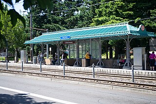
Ruby Junction/East 197th Avenue is a MAX light rail station in Gresham, Oregon. It serves the Blue Line and is the 22nd stop eastbound on the eastside MAX line. The station is at the intersection of SE 197th Avenue and Burnside Street.

Rockwood/East 188th Avenue is a MAX light rail station in Gresham, Oregon. It serves the Blue Line and is the 21st stop eastbound on the eastside MAX branch. The station is at the intersection of Southeast 188th Avenue and Burnside Street, within the Rockwood neighborhood. This station is a hub for bus service to Gateway Transit Center and Gresham Transit Center.

East 181st Avenue station is a MAX light rail station in Gresham, Oregon. It serves the Blue Line and is the 20th stop eastbound on the eastside MAX line.

East 172nd Avenue station is a MAX light rail station in Gresham, Oregon. It serves the Blue Line and is the 19th stop eastbound on the eastside MAX line. The MAX system is owned and operated by TriMet, the major transit agency for the Portland metropolitan area.
East 162nd Avenue station is a MAX light rail station on the boundary between Portland and Gresham in Oregon, USA. It serves the Blue Line and is the 18th stop eastbound on the current Eastside MAX branch.

East 102nd Avenue station is a MAX light rail station in Portland, Oregon. It serves the Blue Line and is the 15th stop eastbound on the current Eastside MAX branch.

East 148th Avenue station is a MAX light rail station in Portland, Oregon. It serves the Blue Line and is the 17th stop eastbound on the current Eastside MAX branch. It is located at the intersection of East Burnside Street and NE/SE 148th Avenue, serving the Hazelwood, Glenfair and Wilkes neighborhoods. The MAX system is owned and operated by TriMet, the major transit agency for the Portland metropolitan area.

Northeast 60th Avenue is a light rail station on the MAX Blue, Green and Red Lines in Portland, Oregon. It is the 12th stop eastbound on the eastside MAX line. It is located on the boundary between the North Tabor and Rose City Park neighborhoods.

The Northeast 82nd Avenue station is a light rail station on the MAX Blue, Green and Red Lines in Portland, Oregon. It is the 13th stop eastbound on the eastside MAX. It serves the neighborhoods of Rose City Park, Roseway, Madison South, Montavilla and Mount Tabor.

Lloyd Center/Northeast 11th Avenue is a light rail station on the MAX Blue, Green and Red Lines in Portland, Oregon. It is the 10th stop eastbound on the Eastside MAX. The station is located on the 1200 block of Northeast Holladay Street in Lloyd District.
Northeast 7th Avenue is a light rail station on the Blue, Green and Red Lines in Portland, Oregon. It is the 9th stop eastbound on the Eastside MAX.

Convention Center station is a light rail station on the MAX Blue, Green and Red Lines in Portland, Oregon. It is the 8th stop eastbound on the current Eastside MAX, having not been built when the original line opened, in 1986. It was built to serve the Oregon Convention Center, which did not exist when the MAX line opened, and was completed and opened in the same month as the Convention Center, September 1990.

Old Town/Chinatown station is a MAX Light Rail station served by the Blue and Red Lines. It is located in the Old Town Chinatown neighborhood in Portland, Oregon and is currently the 6th stop eastbound on the Eastside MAX. It is also the last stop before crossing the Willamette River. It is next to the Portland Downtown Heliport. The station was previously also served by the Yellow Line, from 2004 to 2009, until that line's relocation to the Portland Transit Mall.

The Skidmore Fountain station is a light rail station on the MAX Blue and Red Lines in Portland, Oregon. It is currently the fifth stop eastbound on the Eastside MAX. It was previously also served by the Yellow Line, from 2004 to 2009, until that line's relocation to the Portland Transit Mall.

Mall/Southwest 4th Avenue and Mall/Southwest 5th Avenue were a pair of light rail stations in Portland, Oregon, United States, served by TriMet as part of the MAX Light Rail system. Built into the sidewalk at Southwest Yamhill and Morrison streets between 4th and 5th avenues in downtown Portland, the Mall stations were served by the Blue and Red lines upon closing. They had also been served by the Yellow Line from May 2004 to August 2009.

Kings Hill/Southwest Salmon Street is a former light rail station in Portland, Oregon, United States, which was served by the Blue and Red lines of TriMet's MAX Light Rail. The station was situated within the Goose Hollow neighborhood. Its incorrectly punctuated name refers to the hillside to the west of the station, which has historically been referred to as King's Hill. A section of King's Hill, which contains many historic buildings, qualified for inclusion within the King's Hill Historic District, the easternmost boundary of which is at SW 21st Avenue.

Interstate/Rose Quarter station is a light rail station on the MAX Yellow Line in Portland, Oregon. It is the first stop northbound on the Interstate MAX extension. About 200 yards away is the Rose Quarter Transit Center's MAX station, where transfers to the eastbound MAX Blue and Red lines and the southbound Green Line are possible. Several bus lines also serve the transit center, making stops in the area between the two MAX stations.

North Killingsworth Street is a light rail station on the MAX Yellow Line in Portland, Oregon. It is the fifth stop northbound on the Interstate MAX extension.

Lents Town Center/Southeast Foster Road is a light rail station on the MAX Green Line in Portland, Oregon. It is the 5th stop southbound on the I-205 MAX branch. The station is at the intersection of Interstate 205 and Foster Road. It is located in the Lents neighborhood's town center business district. It also provides access to the Springwater Corridor, which was once a transit line to the suburbs and is now a dedicated bikeway through southeast Portland.
Providence Park is a light rail station on the MAX Blue and Red lines located in the Goose Hollow neighborhood of Portland, Oregon. It is named after the adjacent stadium, Providence Park. The station primarily serves Providence Park and residential areas around West Burnside Street. The station, consisting of separate eastbound and westbound platforms built into city sidewalks between SW 17th and SW 18th Avenues on SW Yamhill and SW Morrison Streets, opened on August 31, 1997.

