
Suncook is a census-designated place (CDP) in Merrimack County, New Hampshire, United States. The population was 5,501 at the 2020 census. Approximately two-thirds of Suncook is located in the town of Pembroke, with the remainder in Allenstown.

St. Paul is a town in Collin County, Texas, United States. The population was 1,066 at the 2010 census, up from 630 at the 2000 census.
Honeyville is a city near the eastern edge of Box Elder County, Utah, United States. The population was 1,441 at the 2010 census.

Millville is a city in Cache County, Utah, United States. The population was 2,222 at the 2020 census, with an estimated population of 2,300 in 2022. It is included in the Logan, Utah-Idaho Metropolitan Statistical Area.

Wellsville is a city in Cache County, Utah, United States. The population was 3,432 at the 2010 census, with an estimated population of 3,849 in 2018. It is included in the Logan, Utah-Idaho Metropolitan Statistical Area.

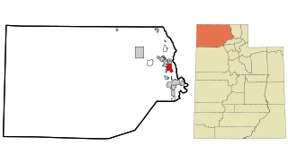
East Carbon is a city in Carbon County, Utah, United States. The population was 1,301 at the 2010 census. East Carbon was incorporated on July 23, 1973, from the merger of the two struggling mining towns of Dragerton and Columbia. On January 1, 2014, the city annexed the neighboring city of Sunnyside.
Price is a city in the U.S. state of Utah and the county seat of Carbon County. The city is home to Utah State University Eastern, as well as the USU Eastern Prehistoric Museum. Price is located within short distances of both Nine Mile Canyon and the Manti-La Sal National Forest.
Sunnyside is a former city in Carbon County, Utah, United States. The population was 377 at the 2010 census. On January 1, 2014, the city merged with the neighboring city of East Carbon.

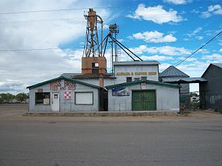
Wellington is a city in Carbon County, Utah, United States. The population was 1,676 at the 2010 census. The community was settled in 1878 by a band of thirteen Mormons led by Jefferson Tidwell. The town was named for Justus Wellington Seeley, Jr., of the Emery County Court. Many residents commute to nearby Price for their jobs, or work in one of the various coal mines in the area.

Fruit Heights is a city in eastern Davis County, Utah, United States. It is part of the Ogden–Clearfield, Utah Metropolitan Statistical Area. It lies along the Wasatch Front adjacent to the larger cities of Farmington and Kaysville. Its population was 4,987 at the 2010 census, with an estimated population of 6,234 in 2018.

North Salt Lake is a city in Davis County, Utah, United States. It is part of the Ogden–Clearfield, Utah Metropolitan Statistical Area. The population was 16,322 at the 2010 census, which had risen to an estimated 20,948 as of 2019.
Myton is a city in Duchesne County, Utah, United States. Established in 1905, Myton had a population of 569 at the 2010 census.

Kanarraville is a town in Iron County, Utah, United States. The population was 355 at the 2010 census.

Hanksville is a small town in Wayne County, Utah, United States, at the junction of State Routes 24 and 95. The population was 219 at the 2010 census.

Ward Township is one of the eleven townships of Hocking County, Ohio, United States. As of the 2010 census the population was 1,933, of whom 1,469 lived in the unincorporated portions of the township.
Kenilworth is a census-designated place in northern Carbon County, Utah, United States.
The Claremont–Lebanon Micropolitan Statistical Area, as defined by the United States Census Bureau, is an area consisting of four counties – two in New Hampshire and two in Vermont, anchored by the cities of Lebanon, New Hampshire and Claremont, New Hampshire. At the 2010 census, the area was defined as two separate Micropolitan Statistical Areas (μSAs), Claremont and Lebanon. The Claremont μSA, consisting of Sullivan County, New Hampshire, had a population of 43,742, while the Lebanon μSA, comprising Grafton County, New Hampshire, and Orange and Windsor counties in Vermont, had a population of 174,724. In 2013, the two areas were combined to form the Claremont-Lebanon μSA, and in 2015 the estimated population was 216,923. The Claremont–Lebanon μSA is the most populous micropolitan area in the United States.

Spring Glen is a census-designated place in Carbon County, in eastern Utah, United States. The population was 1,126 at the 2010 census. Founded in 1878, Spring Glen was the first permanent settlement in what is now Carbon County. First settled principally by white Mormon farmers, the community became much more diverse after about 1890, when the development of the area's coal mines brought an influx of immigrants from Southern Europe and other regions.
Carbonville is a census-designated place in Carbon County, Utah, United States. The population was 1,567 at the 2010 census.

West Wood is a census-designated place (CDP) in Carbon County, Utah, United States. The population was 844 at the 2010 census.


