East Norfolk Railway

Last updated

East Norfolk Railway
Wax seal of the East Norfolk Railway.jpg
East Norfolk Railway map.png
ENR lines in red, proposed in yellow.
Foulsham station.jpg
Foulsham station, ENR
Overview
HeadquartersLondon
LocaleNorfolk, UK
Dates of operation18591881
Successor Great Eastern Railway
Technical
Track gauge 4 ft 8+12 in (1,435 mm)

The East Norfolk Railway was a pre-grouping railway company operating a standard gauge 25 mile, mostly single track, railway running between Norwich Thorpe railway station and Cromer in the English county of Norfolk. It opened in 1874, reaching Cromer three years later, and remains mostly operational. The company also operated a branch between Wroxham and County School, which closed to passengers in 1952, and had proposed a branch to Blakeney in 1878, which was never constructed.

Contents

History

The plans for the East Norfolk Railway's Aylsham, Cromer and North Walsham lines were first deposited in 1859. [1] The line opened as far as North Walsham in 1874, but was in an incomplete state – with neither crossing keeper's cottages or goods sheds being finished. This contributed to a lack of early cash flow, and liquidity, delayed the extension to Cromer. [2] A temporary railhead was opened at Gunton on 29 July 1876. [3] Gunton station, and the crossing keeper's cottages to the south, were built by Lord Suffield to blend into the estate. [4] The single track railway between Norwich and Cromer being finally opened for the summer of 1877 – although the lightly constructed sand embankments were noted as a concern by the line's inspector. At this time, North Walsham contributed 68.5% of the line's receipts. [5]

The 1864 Act included plans for a line to Aylsham, diverging south of Wroxham station. In 1876 this plan was revived, and modified, to leave the main line north of Wroxham station. [6] The branch line diverged on a tight 10 chain curve at Wroxham Junction. [7] A large granary was provided at Aylsham, stables were provided at Coltishall for the malt trade and a local man paid for a large shed at Buxton. [8] The Great Eastern Railway had taken control of the East Norfolk Railway in 1881, before this line was completed. [9] The branch joined the Great Eastern Railway's line from Dereham to Fakenham at Broom Green, where there was a 20 chain curve. [7] The complete line opened in 1882. [10]

Although nominally independent, the East Norfolk Railway was operated by the Great Eastern Railway from the start of services, and soon passed into ownership of the latter company. [11] Fares on the line, along with goods rates, were harmonized with, and set by, the Great Eastern Railway. [4]

Routes

Norwich to Cromer

East Norfolk Railway
Main line
BSicon exKHSTa.svg
Cromer High
BSicon exdCONTgq.svg
BSicon exKRZo.svg
BSicon exdCONTfq.svg
BSicon lCONTf4.svg
BSicon xv-ABZg+4.svg
BSicon HST.svg
Gunton
BSicon exlCONTf1.svg
BSicon evABZg+1-.svg
BSicon exdCONTgq.svg
BSicon eKRZo.svg
BSicon exdCONTfq.svg
BSicon HST.svg
North Walsham
BSicon HST.svg
Worstead
BSicon exdCONTgq.svg
BSicon eABZg+r.svg
BSicon HST.svg
Wroxham
BSicon hbKRZWae.svg
BSicon HST.svg
Salhouse
BSicon ABZg+l.svg
BSicon dCONTfq.svg
BSicon eHST.svg
Whitlingham Junction
BSicon hbKRZWae.svg
BSicon ABZg+l.svg
BSicon dCONTfq.svg
BSicon KHSTe.svg
Norwich Thorpe
Worstead station, with former signal box in distance Worsteadshelter.jpg
Worstead station, with former signal box in distance
Cromer High (then just "Cromer") shortly after opening Cromer High in early days.jpg
Cromer High (then just "Cromer") shortly after opening

Leaving Norwich Thorpe station, the line followed the Norfolk and Yarmouth Railway until it reached a small halt at Whitlingham railway station. This station has been closed, and the platforms removed. The East Norfolk line leaves the Norfolk and Yarmouth; climbing a 1 in 80 bank for about a mile northwards from Whitlingham Junction.

Leaving the Yare valley, trains arrive at Salhouse station, 6 miles from Norwich, which retains two operational platforms, although the goods yard closed on 18 April 1966. The original ENR timber building on the down platform has been demolished, although the later GER building on the up platform survives.

The next station was reached after passing over the longest viaduct on the route, a 55-foot structure originally built using timber but rebuilt in the 1890s, over the River Bure. Wroxham was 8½ miles from Norwich. This was formerly the junction for the ENR branch line to Aylsham and County School, and also marks the limit of the double track section. The branch line formerly diverged from the Cromer line a short distance north of the station, but closed to all traffic in 1982 and was subsequently dismantled, replaced by the Bure Valley Railway. The station had coal and grain handling facilities in the yard north east of the station and, although this yard is no longer in use, the isolated tracks remain.

Worstead railway station, 13 miles from Norwich, is the next halt. Although originally equipped with two platforms, only one remains in use. The goods yard was closed on 13 July 1964, but the abolished signal box remains in situ as a shed and garage.

The next station, located 16 miles from Norwich, was formerly known as North Walsham Main railway station to distinguish it from North Walsham Town railway station on the rival Midland and Great Northern Joint Railway, but is now simply referred to as North Walsham. The station was also formerly used to serve trains working on the Norfolk and Suffolk Joint Railway route to Mundesley. The station is equipped with a passing loop, although the original station buildings and signal box have been demolished.

Leaving North Walsham, trains soon pass over the former Midland and Great Northern line to Melton Constable, now in use as part of the Weavers' Way long-distance footpath. Part of the Norfolk and Suffolk line to Mundesley has been used, along with part of the Midland and Great Northern line to Yarmouth, as the North Walsham bypass, which can be seen paralleling the route through the town.

The next station, 19 miles from Norwich, is at Gunton railway station. There is no village of this name, and the station is actually situated in the parish of Thorpe Market. Gunton Station was built primarily for the convenience of Lord Suffield (a major investor in the original East Norfolk Railway Company [12] ). Gunton's original station buildings are preserved but are no longer in the ownership of the railway.

The line climbs steeply away from Gunton station, with the original route into Cromer being abandoned by the modern railway approximately half a mile from the original terminus - at the site of the former Cromer Junction with the Norfolk and Suffolk Joint Railway.

The terminus of the line was Cromer High railway station, the first station opened in Cromer, situated to the south on the outskirts of the town on a steep escarpment. [13] The station (along with the East Norfolk line) was incorporated into the Great Eastern Railway, who had operated the services from the beginning. [13] It served as the terminus of Great Eastern Railway services from London and Norwich. Initially named "Cromer" on opening, it was renamed "Cromer High" in 1948. [13]

The station opened on 26 March 1877. Because of steep gradients near the town, the station was built in open fields some distance from the town itself. [12]

On 20 September 1954 passenger services ceased at Cromer High, with all traffic diverted to Cromer Beach (now renamed "Cromer"). The station remained open as a freight terminus until 7 March 1960, but was then closed completely and the station demolished. [12]

Wroxham to County School

East Norfolk Railway, Aylsham branch
BSicon exCONTg.svg
Mid-Norfolk Railway
to Wymondham
BSicon xHST.svg
County School BSicon lDAMPF.svg
BSicon exABZgl.svg
BSicon exCONTfq.svg
Wymondham to Wells Branch
to Wells-next-the-Sea
BSicon exHST.svg
Foulsham
BSicon exHST.svg
Reepham
BSicon exHST.svg
Cawston
BSicon uKHSTa.svg
BSicon exBHF.svg
Aylsham BSicon lDAMPF.svg
(formerly Aylsham South)
BSicon uHST.svg
Brampton BSicon lDAMPF.svg
BSicon uHST.svg
Buxton BSicon lDAMPF.svg
BSicon exlHST.svg
BSicon uSTR.svg
Buxton Lamas
BSicon uHST.svg
Coltishall BSicon lDAMPF.svg
BSicon uKRW+l.svg
BSicon uKRWr.svg
BSicon xABZg+l.svg
BSicon CONTfq.svg
Bittern Line
to Sheringham
BSicon uKBHFe.svg
BSicon STR.svg
Wroxham BSicon lDAMPF.svg
BSicon BHF.svg
Hoveton & Wroxham
BSicon CONTf.svg
Bittern Line
to Norwich
Replica junction board at County School, 2019 County School running in board.jpg
Replica junction board at County School, 2019
Postcard view of Foulsham station Foulsham station postcard 1.jpg
Postcard view of Foulsham station
Reepham station in 2008 Reepham railway station in 2008.jpg
Reepham station in 2008

The ENR branch line to Aylsham and County School diverged westwards from the Cromer line just north of Wroxham station on a 10 chain radius curve. The "Western Extension" opened as far as Aylsham on 1 January 1880, with service reaching Cawston on 1 September. The line to Reepham was opened in 1881, at the same time as the East Norfolk Railway was amalgamated with the Great Eastern Railway. County School was opened as the junction with the former Norfolk Railway line from Norwich to Fakenham in 1882. [14]

Passenger services over the line ended on 15 September 1952, with the line between Reepham and Foulsham also being closed to goods. This section was then partially relaid in 1960, with the Themelthorpe Curve goods link with the former Norwich line of the M&GN being opened 12 September. The remaining section of line between Foulsham and County School was closed on 31 October 1964. [15] Buxton Lamas and Coltishall closed to goods on 18 April 1966. [14] The line between Themelthorpe and Wroxham remained in use as a goods line until the 1980s.

The first station after Wroxham was at Coltishall, followed by Buxton railway station and Aylsham. This section is still in use as the Bure Valley Railway. Although the passenger service ended in 1952, freight traffic continued until 1981 and the line through Aylsham was formally closed on 6 January 1982. A weed-killing train ran in 1983 and track-lifting trains ran the following year.. In 1990, the station buildings at Aylsham, then one of the most complete remaining Great Eastern stations in Norfolk, were obliterated to make way for the Bure Valley Railway whose headquarters now occupy the site. [16]

Beyond Aylsham the route survives as part of the Marriott's Way long-distance footpath and cycleway. The next station was at Cawston, where the building survives as a private residence, although the formation and platforms have been buried. Cawston was the planned location of the junction for the proposed, but never built, branch line to the coast at Blakeney, with a triangle on the Aylsham side of the village being shown on plans.

The next station, Reepham also remains, along with its large goods shed and former yard, although a road improvement scheme in the town has partially blocked a section of the line. Although the tracks have been removed, the Whitwell and Reepham railway intend to restore railway services to this station.

Just west of Reepham is the Themelthorpe Curve, connecting the ENR to the Midland and Great Northern line to Norwich City railway station - one of the last sections of railway line to have been built in Norfolk. This also marks the point where the Marriott's Way leaves the formation.

West of Themelthorpe the ENR originally passed under the Midland and Great Northern, and the abutments of the bridge can still be seen. The line then continues to Foulsham. The section between Themelthorpe and Foulsham is the longest-closed section of the route, having been totally abolished in 1952. Although closed to passengers at this time, goods traffic on the section between Foulsham and County School until 31 October 1964. [15]

The final section of embankment before Broom Green has been ploughed in, and few traces remain of the southern cord of the ENR triangle connecting with the MNR. The cutting forming the northern cord of the triangle, which was never laid with track, survives. From Broom Green shares the formation of former Wymondham, Dereham, Fakenham and Wells-next-the-Sea for the final mile to County School.

Cawston to Blakeney (proposed, but not built)

The East Norfolk Railway proposed a line from Cawston to Cley and Blakeney in 1879, with an intermediate station planned for Holt. It was estimated that this line would cost £300,000, but generate only £7 per mile per week [17] - but the main intention of the line was block access by rival companies. The proposed line had very little local support, especially in Holt - where the station was in fact going to be located in Letheringsett rather than the named town. [18]

Present day operations

Bittern Line train at Worstead. A train has arrived at Worstead Station - geograph.org.uk - 1047310.jpg
Bittern Line train at Worstead.

The main line remains in regular operation between Norwich and Cromer, with the exception of Cromer High railway station. Trains approaching Cromer use part of the formation of the Norfolk and Suffolk Joint Railway, before joining the former Midland & Great Northern Joint Railway (M&GN) at Cromer Beach railway station. It is presently marketed as the Bittern Line, and formed part of Network Rail Network Rail Route 7, as SRS 07.11 - East Suffolk line and Norfolk branches. Since 2010 it is a part of Strategic Route D: East Anglia. [19]

The first 9 miles (14 kilometres) of the branch line, between Wroxham railway station and Aylsham railway station, operates as the Bure Valley Railway 15 in (381 mm) minimum gauge heritage railway.

Related Research Articles

<span class="mw-page-title-main">North Norfolk Railway</span> Heritage railway in Norfolk, England

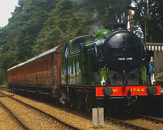
The North Norfolk Railway (NNR) – also known as the "Poppy Line" – is a 5+14-mile (8.4 km) heritage steam railway in Norfolk, England, running between the towns of Sheringham and Holt. The North Norfolk Railway is owned and operated as a public limited company, originally called Central Norfolk Enterprises Limited. The railway is listed as exempt from the UK Railways (Interoperability) Regulations 2000.

<span class="mw-page-title-main">Wroxham</span> Human settlement in England

Wroxham is a village and civil parish in the English county of Norfolk. The civil parish of Wroxham has an area of 6.21 square kilometres, and in 2001, had a population of 1,532 in 666 households. A reduced population of 1,502 in 653 households was noted in the 2011 Census. The village is situated within the Norfolk Broads on the south side of a loop in the middle reaches of the River Bure. It lies in an elevated position above the Bure, between Belaugh Broad to the west, and Wroxham Broad to the east and south east. Wroxham is some eight miles north-east of Norwich, to which it is linked by the A1151 road. The village and broad lie in an area of fairly intensive agriculture, with areas of wet woodland adjoining the broad and river. For the purposes of local government, the parish falls within the district of Broadland although the river, broad and their immediate environs fall within the executive area of the Broads Authority. On the northern side of the Bure is the village of Hoveton, often confused with Wroxham.

<span class="mw-page-title-main">Bure Valley Railway</span>

The Bure Valley Railway is a 15 in minimum gauge visitors' attraction in Norfolk, England. It was created on the original disused full-gauge bed of a defunct passenger service to incorporate a new, adjacent pedestrian footpath.

<span class="mw-page-title-main">River Bure</span> River in Norfolk, England

The River Bure is a river in the county of Norfolk, England, most of it in the Broads. The Bure rises near Melton Constable, 11 miles (18 km) upstream of Aylsham, which was the original head of navigation. Nowadays, the head of navigation is 10 miles (16 km) downstream at Coltishall Bridge. After Aylsham Lock and Burgh Bridge, the Bure passes through Buxton Lammas, Coltishall, Belaugh, Wroxham, Horning, past St. Benet's Abbey, through Oby, Acle, Stokesby, along the northern border of the Halvergate Marshes, through Runham and Great Yarmouth where it meets Breydon Water and flows into the sea at Gorleston.

<span class="mw-page-title-main">Marriott's Way</span> Disused railway, now bridleway, between Norwich and Aylsham

The Marriott's Way is a long-distance footpath, cycle-path and bridleway in north Norfolk, England, between Norwich and Aylsham via Themelthorpe. It forms part of the National Cycle Network (NCN) and the red route of Norwich's Pedalways cycle path network. It is open to walkers, cyclists and horse riders. Its total length is 24.6 miles (39.5 km). It has a mixture of surfaces: tarmac, compacted gravel and earth. The name of the route originates from the chief engineer and manager of the Midland and Great Northern Joint Railway (M&GNJR), William Marriott, who held the position for 41 years.

<span class="mw-page-title-main">Aylsham</span> Town in Norfolk, England

Aylsham is a historic market town and civil parish on the River Bure in north Norfolk, England, nearly 9 mi (14 km) north of Norwich. The river rises near Melton Constable, 11 miles (18 km) upstream from Aylsham and continues to Great Yarmouth and the North Sea, although it was only made navigable after 1779, allowing grain, coal and timber to be brought up river.

<span class="mw-page-title-main">Bittern Line</span>

The Bittern Line is a railway branch line in Norfolk, England, that links Norwich to Sheringham. It passes through the Broads on its route to an Area of Outstanding Natural Beauty on the north Norfolk coast. It is named after the bittern, a rare bird found in the reedy wetlands of Norfolk.

<span class="mw-page-title-main">Mid Norfolk (UK Parliament constituency)</span> Parliamentary constituency in the United Kingdom, 1983 onwards

Mid Norfolk is a constituency represented in the House of Commons of the UK Parliament since 2010 by George Freeman, a Conservative.

<span class="mw-page-title-main">County School railway station</span> Railway station in Norfolk, England

County School railway station is on the Mid-Norfolk Railway in Norfolk, England; it will serve the villages of North Elmham and Guist once services resume. It is 17 miles 40 chains (28 km) down the line from Wymondham and is the northernmost station owned by the Mid-Norfolk Railway Preservation Trust.

<span class="mw-page-title-main">Hoveton & Wroxham railway station</span> Railway station in Norfolk, England

Hoveton & Wroxham railway station is on the Bittern Line in Norfolk, England, serving the village of Hoveton and the adjacent village of Wroxham. It is 8 miles 61 chains (14.1 km) down the line from Norwich and is situated between Salhouse and Worstead.

<span class="mw-page-title-main">North Walsham railway station</span> Railway station in Norfolk, England

North Walsham railway station is on the Bittern Line in Norfolk, England, serving the town of North Walsham. It is 16 miles (26 km) down the line from Norwich, between Worstead to the south and Gunton to the north.

<span class="mw-page-title-main">Railway stations in Cromer</span> Railway stations in Cromer, Norfolk, UK

The fishing port and holiday resort of Cromer in the English county of Norfolk has had a rail service since 1877. It was served by three railway stations for many years, and is now served by two. Cromer Beach station, which opened in 1887, was renamed Cromer following the closure of the other early stations.

<span class="mw-page-title-main">Reepham, Norfolk</span> Town in Norfolk, England

Reepham is a market town and civil parish in the Broadland district of Norfolk, England. Reepham is situated on the B1145 road between the Bure and Wensum valleys. The town is 12 miles (19 km) northwest of Norwich. At the time of the 2001 census the civil parish had a population of 2,455 residents in 970 households, occupying an area of 1,909 hectares. increasing to a population of 2,709 in 1,169 households at the 2011 census.

The following are lists of recreational walks in Norfolk, England.

<span class="mw-page-title-main">Guestwick</span> Human settlement in England

Guestwick is a village and a civil parish in the English county of Norfolk. The village is 19.6 miles (31.5 km) south-west of Cromer, 18.7 miles (30.1 km) north-west of Norwich and 131 miles (211 km) north-east of London. The village lies 10.2 miles (16.4 km) west of the nearby town of Aylsham. The village lies far from any High roads. The nearest railway station is at Sheringham for the Bittern Line which runs between Sheringham, Cromer and Norwich. The nearest airport is Norwich International Airport.

<span class="mw-page-title-main">Whitwell & Reepham railway station</span> Railway station in Norfolk, England

Whitwell and Reepham railway station, also known as Whitwell station, is a former station situated in Norfolk, England. The station closed in 1959 and is a notable stop on the Marriott's Way long-distance footpath. It is being restored as a railway museum, including the re-laying of track.

<span class="mw-page-title-main">Pettywell</span> Human settlement in England

Pettywell is a hamlet within the a civil parish of Reepham in the English county of Norfolk. The hamlet is 8.3 miles (13.4 km) west south west of Aylsham and 14.7 miles (23.7 km) north west of Norwich and 128 miles (206 km) north east of London. The hamlet is on the north side of the B1145 which links King's Lynn and Mundesley. The nearest railway station is at North Walsham for the Bittern Line which runs between Sheringham, Cromer and Norwich.The nearest airport is at Norwich International Airport. For the purposes of local government, the parish of Reepham falls within the district of Broadland.

The Wymondham to Wells Branch was a railway built in stages by the Norfolk Railway, Eastern Counties Railway and Wells and Fakenham Company between 1847 and 1857. The railway ran from Wymondham in the south, through Dereham and Fakenham to the coastal town of Wells-next-the-Sea; more specifically, the line ran from Wymondham South Junction, where it met the present-day Breckland Line. Passenger services along the line lasted until 1969; the railway continued to be used for freight until 1989. The southern section of the railway now forms the Mid-Norfolk Railway, with part of the northern section serving as the narrow gauge Wells and Walsingham Light Railway.

References

  1. Joby, R. S. (1975). The East Norfolk Railway. Klofron. p. 48.
  2. Joby, R. S. (1975). The East Norfolk Railway. Klofron. p. 16.
  3. Joby, R. S. (1975). The East Norfolk Railway. Klofron. p. 19.
  4. 1 2 Joby, R. S. (1975). The East Norfolk Railway. Klofron. p. 25.
  5. Joby, R. S. (1975). The East Norfolk Railway. Klofron. p. 20.
  6. Joby, R. S. (1975). The East Norfolk Railway. Klofron. p. 29.
  7. 1 2 Joby, R. S. (1975). The East Norfolk Railway. Klofron. p. 35.
  8. Joby, R. S. (1975). The East Norfolk Railway. Klofron. p. 31.
  9. Joby, R. S. (1975). The East Norfolk Railway. Klofron. p. 32.
  10. Joby, R. S. (1975). The East Norfolk Railway. Klofron. p. 46.
  11. Quayle, H. I.; Jenkins, Stanley (1980). Branch Lines Into The Eighties. Devon: David and Charles. pp. 66–69. ISBN   978-0-7153-7980-6. OCLC   753324009.
  12. 1 2 3 Adderson, Richard; Kenworthy, Graham (1998). Branch Lines Around Cromer. Midhurst: Middleton Press. ISBN   978-1-901706-26-0.
  13. 1 2 3 Catford, Nick. "Cromer High". Subterranea Britannica. Retrieved 21 December 2007.
  14. 1 2 The East Norfolk Railway, R.S. Joby p.46
  15. 1 2 The East Norfolk Railway, R.S. Joby p.43
  16. Norfolk By Rail
  17. The East Norfolk Railway, R.S. Joby p.33
  18. The East Norfolk Railway, R.S. Joby p.34
  19. Network Rail, Anglia