Eichenbühl

Last updated
Eichenbühl
Wappen von Eichenbuhl.png
Coat of arms
Germany adm location map.svg
Red pog.svg
Eichenbühl
Location of Eichenbühl within Miltenberg district
Eichenbuhl in MIL.svg
Coordinates: 49°42′N9°20′E / 49.700°N 9.333°E / 49.700; 9.333 Coordinates: 49°42′N9°20′E / 49.700°N 9.333°E / 49.700; 9.333
Country Germany
State Bavaria
Admin. region Unterfranken
District Miltenberg
Government
   Mayor Günther Winkler (CSU)
Area
  Total 31.24 km2 (12.06 sq mi)
Elevation 158 m (518 ft)
Population (2017-12-31) [1]
  Total 2,475
  Density 79/km2 (210/sq mi)
Time zone CET/CEST (UTC+1/+2)
Postal codes 63928, 97896 (Ebenheiderhof)
Dialling codes 09371
Vehicle registration MIL
Website www.eichenbuehl.de

Eichenbühl is a community in the Miltenberg district in the Regierungsbezirk of Lower Franconia (Unterfranken) in Bavaria, Germany.

Miltenberg (district) District in Bavaria, Germany

Miltenberg is a Landkreis (district) in Bavaria, Germany. It is bounded by the city of Aschaffenburg, the districts of Aschaffenburg and Main-Spessart, and the states of Baden-Württemberg and Hesse.

<i>Regierungsbezirk</i> subdivision of some of the 16 federal states in Germany

A Regierungsbezirk is a type of administrative division in Germany.

Lower Franconia Regierungsbezirk in Bavaria, Germany

Lower Franconia is one of seven districts of Bavaria, Germany. The districts of Lower, Middle and Upper Franconia make up the region of Franconia.

Contents

Geography

Location

Eichenbühl lies in the Bavarian Lower Main (Bayerischer Untermain) Region.

Constituent communities

Eichenbühl’s Ortsteile are Eichenbühl, Guggenberg, Heppdiel, Pfohlbach, Riedern and Windischbuchen.

History

From the outlying centre of Riedern came the like-named noble family of Riedern whose armorial bearing was a red pot, which is still a charge in the community’s coat of arms today. [2] The community in the Archbishopric of Mainz was awarded in the 1803 Reichsdeputationshauptschluss to the Principality of Leiningen, then mediatized by Baden, and in 1810 ceded to the Grand Duchy of Hesse-Darmstadt. In the Hesse-Bavaria Rezeß in Frankfurt in 1816, it finally passed to Bavaria. In the course of administrative reform in Bavaria, the current community came into being with the Gemeindeedikt (“Municipal Edict”) of 1818.

Charge (heraldry) heraldic motif; an ordinary, common charge or symbol

In heraldry, a charge is any emblem or device occupying the field of an escutcheon (shield). This may be a geometric design or a symbolic representation of a person, animal, plant, object or other device. In French blazon, the ordinaries are called pièces while other charges are called meubles.

Coat of arms unique heraldic design on a shield or escutcheon

A coat of arms is a heraldic visual design on an escutcheon, surcoat, or tabard. The coat of arms on an escutcheon forms the central element of the full heraldic achievement which in its whole consists of shield, supporters, crest, and motto. A coat of arms is traditionally unique to an individual person, family, state, organization or corporation.

<i lang="de" title="German language text">Reichsdeputationshauptschluss</i>

The Reichsdeputationshauptschluss, sometimes referred to in English as the Final Recess or the Imperial Recess of 1803, was a resolution passed by the Reichstag of the Holy Roman Empire on 24 March 1803. It was ratified by the Emperor Francis II and became law on 27 April. It proved to be the last significant law enacted by the Empire before its dissolution in 1806.

Population development

Within town limits, 2,553 inhabitants were counted in 1970, 2,680 in 1987, in 2000 2,809 and in 2013 2,572.

Politics

Community council

The mayor is Günther Winkler (CSU).

The council is made up of 14 council members, with the seats apportioned thus:

Social Democratic Party of Germany political party in Germany

The Social Democratic Party of Germany is a social-democratic political party in Germany.

Coat of arms

The community’s arms might be described thus: Per saltire in chief gules a wheel spoked of six argent, dexter argent a pot of the first with two spouts, sinister a flag, the pole of the first per bend sinister, the flag square of the first to sinister of the pole, thereon a cross bottonnée of the field, in base gules issuant from the base point palewise an oak sprig leafed of two and acorned of three of the second.

The six-spoked Wheel of Mainz and the tinctures argent and gules (silver and red) refer to Electoral Mainz’s former overlordship. The red pot is taken from the arms formerly borne by the Lords of Riedern, who were first mentioned in 1206, and who died out in 1588. The flag stands for Heppdiel, the cross thereon being Saint Maurice’s cross, referring to Saint Maurice’s Parish Church in Heppdiel. The oak sprig is canting for the name Eichenbühl (Eiche means “oak” in German), and was drawn from Eichenbühl’s old arms, discarded in 1959.

Wheel of Mainz heraldic figure

The Wheel of Mainz or Mainzer Rad, in German, was the coat of arms of the Archbishopric of Mainz and thus also of the Electorate of Mainz (Kurmainz), in Rhineland-Palatinate, Germany. It consists of a silver wheel with six spokes on a red background. The wheel can also be found in stonemasons' carvings and similar objects. Currently, the City of Mainz uses a double wheel connected by a silver cross.

Tincture (heraldry) colour used to emblazon a coat of arms in heraldy

Tinctures constitute the limited palette of colours and patterns used in heraldry. The need to define, depict, and correctly blazon the various tinctures is one of the most important aspects of heraldic art and design.

Saint Maurice leader of the legendary Roman Theban Legion

Saint Maurice was the leader of the legendary Roman Theban Legion in the 3rd century, and one of the favorite and most widely venerated saints of that group. He was the patron saint of several professions, locales, and kingdoms. He is also a highly revered saint in the Coptic Orthodox Church of Alexandria and other churches of Oriental Orthodoxy.

The arms have been borne since 1995. [3]

Sport

Yearly, the AvD/GAMSC International Lower Franconia Hillclimb is held. Each year, the hillclimb enjoys greater enthusiasm. The course is 3.05 km long and leads along Staatsstraße (State Road) 507 from Eichenbühl to Umpfenbach.

Economy and infrastructure

According to official statistics, there were 254 workers on the social welfare contribution rolls working in trade and transport in 1998. In other areas, 76 workers on the social welfare contribution rolls were employed, and 1,009 such workers worked from home. There were 0 processing businesses. Seven businesses were in construction, and furthermore, in 1999, there were 32 agricultural operations with a working area of 1 076 ha, of which 716 ha was cropland and 351 ha was meadowland.

Education

In 1999 the following institutions existed in Eichenbühl:

Related Research Articles

Kleinwallstadt Place in Bavaria, Germany

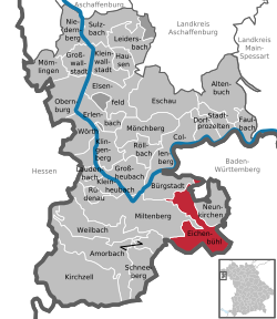
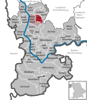
Kleinwallstadt is a market community in the Miltenberg district in the Regierungsbezirk of Lower Franconia (Unterfranken) in Bavaria, Germany and the seat of the like-named Verwaltungsgemeinschaft.

Kleinkahl Place in Bavaria, Germany

Kleinkahl is a community in the Aschaffenburg district in the Regierungsbezirk of Lower Franconia (Unterfranken) in Bavaria, Germany, and a member of the Verwaltungsgemeinschaft of Schöllkrippen. Kleinkahl has around 1,800 inhabitants.

Krombach, Bavaria Place in Bavaria, Germany

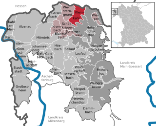
Krombach is a community in the Aschaffenburg district in the Regierungsbezirk of Lower Franconia (Unterfranken) in Bavaria, Germany and a member of the Verwaltungsgemeinschaft of Schöllkrippen.

Rattelsdorf Place in Bavaria, Germany

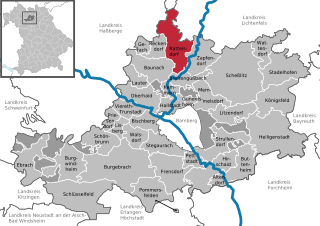
Rattelsdorf is a community with market rights in the Upper Franconian district of Bamberg.

Bischbrunn Place in Bavaria, Germany

Bischbrunn is a community with around 1,800 (2013) inhabitants in the Main-Spessart district in the Regierungsbezirk of Lower Franconia (Unterfranken) in Bavaria, Germany and a member of the Verwaltungsgemeinschaft of Marktheidenfeld.

Mittelsinn Place in Bavaria, Germany

Mittelsinn is a community in the Main-Spessart district in the Regierungsbezirk of Lower Franconia (Unterfranken) in Bavaria, Germany and a member of the Verwaltungsgemeinschaft of Burgsinn.

Neuhütten Place in Bavaria, Germany

Neuhütten is a community in the Main-Spessart district in the Regierungsbezirk of Lower Franconia (Unterfranken) in Bavaria, Germany and a member of the Verwaltungsgemeinschaft of Partenstein. It has a population of around 1,100.

Rechtenbach Place in Bavaria, Germany

Rechtenbach is a community in the Main-Spessart district in the Regierungsbezirk of Lower Franconia (Unterfranken) in Bavaria, Germany and a member of the Verwaltungsgemeinschaft of Lohr am Main. It has a population of around 1,000.

Retzstadt Place in Bavaria, Germany

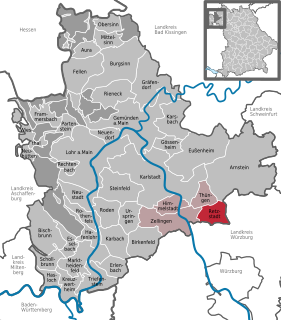
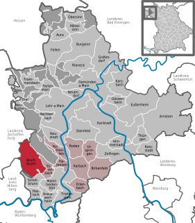
Retzstadt is a community in the Main-Spessart district in the Regierungsbezirk of Lower Franconia (Unterfranken) in Bavaria, Germany and a member of the Verwaltungsgemeinschaft of Zellingen.

Steinfeld, Bavaria Place in Bavaria, Germany

Steinfeld is a community in the Main-Spessart district in the Regierungsbezirk of Lower Franconia (Unterfranken) in Bavaria, Germany and a member of the Verwaltungsgemeinschaft of Lohr am Main.

Zellingen Place in Bavaria, Germany

Zellingen is a market community in the Main-Spessart district in the Regierungsbezirk of Lower Franconia (Unterfranken) in Bavaria, Germany and the seat of the Verwaltungsgemeinschaft of Zellingen.

Altenbuch Place in Bavaria, Germany

Altenbuch is a community in the Miltenberg district in the Regierungsbezirk of Lower Franconia (Unterfranken) in Bavaria, Germany and a member of the Verwaltungsgemeinschaft of Stadtprozelten. Altenbuch has around 1,200 inhabitants.

Elsenfeld Place in Bavaria, Germany

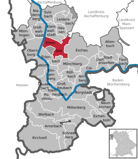
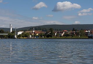
Elsenfeld is a market community in the Miltenberg district in the Regierungsbezirk of Lower Franconia (Unterfranken) in Bavaria, Germany. It is located on the river Main between the hills of the Spessart, east of the river, and Odenwald, west of the river. Elsenfeld has a total population of around 9,000.

Faulbach Place in Bavaria, Germany

Faulbach is a municipality in the Miltenberg district in the Regierungsbezirk of Lower Franconia (Unterfranken) in Bavaria, Germany. It has a population of around 2,600.

Großwallstadt Place in Bavaria, Germany

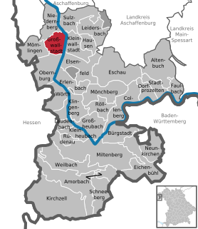
Großwallstadt is a community in the Miltenberg district in the Regierungsbezirk of Lower Franconia (Unterfranken) in Bavaria, Germany.

Hausen, Miltenberg Place in Bavaria, Germany

Hausen is a community in the Miltenberg district in the Regierungsbezirk of Lower Franconia (Unterfranken) in Bavaria, Germany and a member of the Verwaltungsgemeinschaft of Kleinwallstadt.

Laudenbach, Bavaria Place in Bavaria, Germany

Laudenbach is a community in the Miltenberg district in the Regierungsbezirk of Lower Franconia (Unterfranken) in Bavaria, Germany and a member of the Verwaltungsgemeinschaft of Kleinheubach.

Röllbach Place in Bavaria, Germany

Röllbach is a municipality in the Miltenberg district in the Regierungsbezirk of Lower Franconia (Unterfranken) in Bavaria, Germany and a member of the Verwaltungsgemeinschaft of Mönchberg.

Rüdenau Place in Bavaria, Germany

Rüdenau is a municipality in the Miltenberg district in the Regierungsbezirk of Lower Franconia (Unterfranken) in Bavaria, Germany and a member of the Verwaltungsgemeinschaft of Kleinheubach.

Schneeberg, Bavaria Place in Bavaria, Germany

Schneeberg is a market municipality in the Miltenberg district in the Regierungsbezirk of Lower Franconia (Unterfranken) in Bavaria, Germany.

References

  1. "Fortschreibung des Bevölkerungsstandes". Bayerisches Landesamt für Statistik und Datenverarbeitung (in German). September 2018.
  2. Description and explanation of Eichenbühl’s arms at HdBG [ permanent dead link ]
  3. Description and explanation of Eichenbühl’s arms [ permanent dead link ]