Enigma, Georgia

Last updated

Enigma, Georgia
Enigma City Hall.JPG
Enigma City Hall
Berrien County Georgia Incorporated and Unincorporated areas Enigma Highlighted.svg
Location in Berrien County and the state of Georgia
Coordinates: 31°24′41″N83°19′52″W / 31.41139°N 83.33111°W / 31.41139; -83.33111
Country United States
State Georgia
County Berrien
Area
[1]
  Total3.28 sq mi (8.50 km2)
  Land3.25 sq mi (8.42 km2)
  Water0.03 sq mi (0.08 km2)
Elevation
305 ft (93 m)
Population
 (2020)
  Total1,058
  Density325.24/sq mi (125.58/km2)
Time zone UTC-5 (Eastern (EST))
  Summer (DST) UTC-4 (EDT)
ZIP code
31749
Area code 229
FIPS code 13-27596 [2]
GNIS feature ID0313955 [3]

Enigma is a town in Berrien County, Georgia, United States. The population was 1,278 at the 2010 census, [4] and 1,058 in 2020. The origin of the name "Enigma" is obscure; the name is itself an enigma. [5] Enigma has frequently been noted on lists of unusual place names. [6]

Contents

History

Enigma is a small town in South Georgia located in the northwest tip of Berrien County, 9 miles (14 km) east of Tifton, on U.S. Highway 82. The town was founded between 1876-1880 by John A. Ball. It was not initially named "Enigma". Originally a settlement, it was commonly referred to as "Gunn and Weston" until Ball decided he wanted a real name for this town. Two names, "Lax" and "Enigma", were proposed to state officials for review. Lax was already taken by another nearby settlement, and so "Enigma" became the official name. [7] Enigma is an odd name for a town; by definition it means a puzzle or mystery. Ball said, "It was a puzzle what to name it anyway." The town was incorporated on August 21, 1906. [7]

Enigma, circa 1900 Enigma, Georgia (circa 1900).jpg
Enigma, circa 1900

Ball and his family originated in Raleigh, North Carolina, traveling to Georgia on the Brunswick and Western Railroad. He became the town's first postmaster, and not long afterward, Capt J.B. Gunn from Terrell County, Georgia, came as an assistant. Ball and his son Jim started a turpentine business around 1878. Ball returned to Raleigh to bring back a man named Tubb Daughtry and his family to help run the business. He gave them land to live on and permission to worship as they pleased. The turpentine business soon dwindled, and lumber became the main focus. Capt. J. B. Gunn and Capt. S. R. Weston built a sawmill two miles east of Enigma. H. F. Stewart came to work in the sawmill. [7]

Other businesses opened in Enigma throughout the years, including a grocery, merchandise, and hardware stores. E.F. Bussey set up a merchandise store in a building owned at one time by Gunn. This building also housed the U.S. Post Office and sold coffins on its second story. [7] It was located on the south side of the railroad. The railroad's closest depot was in Brookfield, 4 miles (6 km) away. Enigma had a doctor's office run by G.R. Parker. There have been three banks in Enigma throughout the years. Two banks were started around 1915 to 1917, and the other one was started in 1973. The People's Bank opened in 1915 and closed in 1916, and the Ambrose-Enigma Banking Company opened on June 5, 1917, and closed around 1920. The Bank of Alapaha opened a branch in Enigma on March 1, 1973, and is still in business.

Geography

According to the United States Census Bureau, the town has a total area of 3.3 square miles (8.5 km2), of which 3.2 square miles (8.3 km2) is land and 0.04 square miles (0.10 km2), or 1.14%, is water. [4]

Demographics

Historical population
CensusPop.Note
1910 338
1920 3400.6%
1930 3605.9%
1940 52946.9%
1950 499−5.7%
1960 5255.2%
1970 505−3.8%
1980 57413.7%
1990 6116.4%
2000 86942.2%
2010 1,27847.1%
2020 1,058−17.2%
U.S. Decennial Census [8]

At the census of 2000, there were 869 people, 313 households, and 231 families residing in the town. [2] By 2020, its population was 1,058.

Education

The Enigma school was located on the north side of town. It started as a one-room school house, then moved to a three-room school house. A large brick building was built in 1926 to serve as a new school, also on the north side, just across from Highway 82. In the fall of 1954 all county high schools were consolidated into Berrien High in Nashville, the county seat. The original Enigma school building was still in use as part of the elementary school when it burned in October 1973. The gymnasium and cafeteria were still standing, and portable classrooms were brought in so the school could continue until it was rebuilt. [7] Enigma Elementary School was never rebuilt, and the mobile units continued serving the school until it closed at the end of the 1987-88 school year. Enigma Elementary merged with West Berrien Elementary School starting with the 1988-89 school year. The new Northwest Elementary School was housed on the old West Berrien campus. Northwest Elementary School was closed in 1994 in the final consolidation of schools in the county. Now all children are bussed to Berrien Primary, Berrien Elementary, Berrien Middle, and Berrien High in Nashville. The Enigma School grounds now serve as the Enigma City Park.

Related Research Articles

<span class="mw-page-title-main">Wayne County, Georgia</span> County in Georgia, United States

Wayne County is a county located in the southeastern part of the U.S. state of Georgia. As of the 2020 census, the population was 30,144. The county seat is Jesup.

<span class="mw-page-title-main">Tift County, Georgia</span> County in Georgia, United States

Tift County is a county located in the south central portion of the U.S. state of Georgia. As of the 2020 census, the population was 41,344. The county seat is Tifton.

<span class="mw-page-title-main">Lanier County, Georgia</span> County in Georgia, United States

Lanier County is a county in the south central portion of the U.S. state of Georgia. As of the 2020 census, the population was 9,877. The county seat and only incorporated municipality is Lakeland. The county is named after the Georgia poet Sidney Lanier.

<span class="mw-page-title-main">Berrien County, Georgia</span> County in Georgia, United States

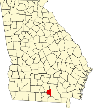
Berrien County is a county located in the south central portion of the U.S. state of Georgia. As of the 2020 census, the population was 18,160. The county seat is Nashville. The county was created February 25, 1856, out of portions of Coffee, Irwin and Lowndes counties by an act of the Georgia General Assembly. It is named after Georgia senator John M. Berrien.

<span class="mw-page-title-main">Jasper, Florida</span> City in Florida, United States

Jasper is a city and the county seat of Hamilton County, Florida, United States. The population was 4,546 at the 2020 census.

<span class="mw-page-title-main">Baxley, Georgia</span> City in Georgia, United States

Baxley is a city in Appling County, Georgia, United States. As of the 2020 census, the city had a population of 4,942. The city is the county seat of Appling County.

<span class="mw-page-title-main">Lula, Georgia</span> City in Georgia, United States

Lula is a city in Hall and Banks counties in the U.S. state of Georgia. Most of the city is in Hall County, with a small eastern portion of the city located in Banks County. The population was 2,822 at the 2020 census. The Hall County portion of Lula is part of the Gainesville, GA Metropolitan Statistical Area. Lula is the home of RailRoad Days, a yearly festival held usually every May. Lula is the railroad junction between the Atlanta northeast line and the Athens north line of Norfolk Southern Railway.

<span class="mw-page-title-main">Alapaha, Georgia</span> Town in Georgia, United States

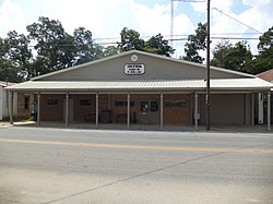
Alapaha is a town in Berrien County, Georgia, United States, along the Alapaha River. As of the 2020 census, the city had a population of 481.

<span class="mw-page-title-main">Nashville, Georgia</span> City in Georgia, United States

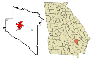
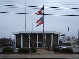
Nashville is a city in and the county seat of Berrien County, Georgia, United States. The population was 7,029 at the 2022 census estimates. It is called the "City of Dogwoods", as the tree grows in large numbers around the area.

<span class="mw-page-title-main">Pembroke, Georgia</span> City and County Seat in Georgia, United States

Pembroke is a city and county seat in Bryan County, Georgia, United States. As of the 2020 census, the population of the city was 2,513. It is located approximately 35 miles west of Savannah, Georgia, and approximately 20 miles south of Statesboro, Georgia. Pembroke is part of the Savannah metropolitan statistical area.

<span class="mw-page-title-main">Canton, Georgia</span> City in Georgia, United States

Canton is a city in and the county seat of Cherokee County, Georgia, United States. As of the 2010 census, the city had a population of 22,958, up from 7,709 in 2000.

<span class="mw-page-title-main">Moultrie, Georgia</span> City in Georgia, United States

Moultrie is the county seat and largest city of Colquitt County, Georgia, United States. It is the third largest city in Southwest Georgia, behind Thomasville and Albany. As of the 2020 census, Moultrie's population was 14,638. It was originally known as Ochlockoney until it was incorporated by the Georgia General Assembly in 1859. Moultrie is an agricultural community set in the Southern Rivers part of Georgia.

<span class="mw-page-title-main">Eastman, Georgia</span> City in Georgia, United States

Eastman is a city in Dodge County, Georgia, United States. The population was 5,658 at the 2020 census, up from 4,962 at the 2010 census. The city was named after William Pitt Eastman, a native of Massachusetts who purchased a large tract of land along the Macon and Brunswick Railroad, and settled a city on the site.

<span class="mw-page-title-main">Vienna, Georgia</span> City in Georgia, United States

The city of Vienna is the county seat of Dooly County, Georgia, United States. The population was 2,928 in 2020. Vienna is situated on the Flint River. It was established as Berrien in 1826. In 1833, its name was changed to Drayton. In 1841, it was renamed Vienna. Vienna was disincorporated at the time they changed the city's name to Vienna. The present name is after Vienna, in Austria.

<span class="mw-page-title-main">Lakeland, Georgia</span> City in Georgia, United States

Lakeland is a city and the county seat of Lanier County, Georgia, United States. The city is the county seat of Lanier County. It is part of the Valdosta, Georgia metropolitan statistical area. The population was 2,875 at the 2020 census.

<span class="mw-page-title-main">Jesup, Georgia</span> City in Georgia, United States

Jesup is a city in Wayne County, Georgia, United States. The population was 9,809 at the 2020 census. The city is the county seat of Wayne County.

<span class="mw-page-title-main">Ellsinore, Missouri</span> City in Missouri, United States

Ellsinore is a town in Carter County, Missouri, United States. The 2020 U.S. Census showed Ellsinore with a population of 416.

<span class="mw-page-title-main">Preston, Nebraska</span> Village in Nebraska, United States

Preston is a village in Richardson County in Southeastern Nebraska, United States. It is located within the Sac and Fox Reservation. The population was 19 at the 2020 census.

<span class="mw-page-title-main">Pine Level, Johnston County, North Carolina</span> Town in North Carolina, United States

Pine Level, chartered 1872, is a town in Johnston County, North Carolina, United States. The population was 1,700 at the 2010 census, up from 1,313 in 2000. Pine Level is located 35 miles (56 km) southeast of Raleigh, the state capital.

<span class="mw-page-title-main">Jump River (CDP), Wisconsin</span> Census-designated place in Wisconsin, United States

Jump River is an census-designated place in the towns of Jump River and McKinley in Taylor County, Wisconsin, United States. It is located on the north bank of the Jump River, from which the hamlet takes its name. As of the 2010 census, its population was 52.

References

  1. "2020 U.S. Gazetteer Files". United States Census Bureau. Retrieved December 18, 2021.
  2. 1 2 "U.S. Census website". United States Census Bureau . Retrieved January 31, 2008.
  3. "US Board on Geographic Names". United States Geological Survey. October 25, 2007. Retrieved January 31, 2008.
  4. 1 2 "Geographic Identifiers: 2010 Demographic Profile Data (G001): Enigma town, Georgia". U.S. Census Bureau, American Factfinder. Archived from the original on February 12, 2020. Retrieved November 4, 2013.
  5. Krakow, Kenneth K. (1975). Georgia Place-Names: Their History and Origins (PDF). Macon, GA: Winship Press. p. 73. ISBN   0-915430-00-2.
  6. Parker, Quentin (2010). Welcome to Horneytown, North Carolina, Population: 15: An insider's guide to 201 of the world's weirdest and wildest places. Adams Media. pp. ix. ISBN   9781440507397.[ permanent dead link ]
  7. 1 2 3 4 5 Cauthen, Edna Dean, Elon Dean Murphy and Estelle Dean McMillan. The History of Berrien County: Enigma, Berrien County, Georgia 1975.
  8. "Census of Population and Housing". Census.gov. Retrieved June 4, 2015.