
Siskiyou County is a county in the northernmost part of the U.S. state of California. As of the 2010 census, the population was 44,900. Its county seat is Yreka and its highest point is Mount Shasta.

Fort Jones is a city in the Scott Valley area of Siskiyou County, California, United States. The population was 839 at the 2010 census, up from 600 as of the 2000 census.

Yreka is the county seat of Siskiyou County, California, United States, located near the Shasta River; the city covers an area of approximately 10 square miles (26 km2), most of which is land. As of the 2010 United States Census, the population was 7,765, reflecting an increase of 475 from the 7,290 counted in the 2000 Census. Yreka is home to the College of the Siskiyous, Klamath National Forest Interpretive Museum and the Siskiyou County Museum.

Klamath County was a county of California from 1851 to 1874. During its existence, the county seat moved twice and ultimately portions of the territory it once had were carved up and added to nearby counties. It was formed from the northwestern portion of Trinity County, and originally included all of the northwestern part of the state, from the Mad River in the south to Oregon in the north, from the Pacific Ocean in the west to the middle of what is now Siskiyou County in the east. It is the only county in California to be disestablished.

The Klamath Mountains are a rugged and lightly populated mountain range in northwestern California and southwestern Oregon in the western United States. They have a varied geology, with substantial areas of serpentinite and marble, and a climate characterized by moderately cold winters with very heavy snowfall and warm, very dry summers with limited rainfall, especially in the south. As a consequence of the geology and soil types, the mountains harbor several endemic or near-endemic trees, forming one of the largest collections of conifers in the world. The mountains are also home to a diverse array of fish and animal species, including black bears, large cats, owls, eagles, and several species of Pacific salmon. Millions of acres in the mountains are managed by the United States Forest Service. The northernmost and largest sub-range of the Klamath Mountains are the Siskiyou Mountains.
Pacific Highway is the name of several north–south highways in the Pacific Coast region of the Western United States, either by legislation officially designating it as such or by common usage.

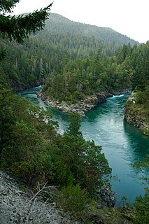
The Siskiyou Mountains are a coastal subrange of the Klamath Mountains, and located in northwestern California and southwestern Oregon in the United States. They extend in an arc for approximately 100 miles (160 km) from east of Crescent City, California, northeast along the north side of the Klamath River into Josephine and Jackson counties in Oregon. The mountain range forms a barrier between the watersheds of the Klamath River to the south and the Rogue River to the north.

The Cascade–Siskiyou National Monument is a United States national monument that protects 114,000 acres (46,134 ha) of forest and grasslands at the junction of the Cascade Range and the Siskiyou Mountains in Southwestern Oregon and Northwestern California, United States. The monument is managed by the Bureau of Land Management as part of the National Landscape Conservation System. It was established in a presidential proclamation by President Bill Clinton on June 9, 2000 and expanded by President Barack Obama on January 12, 2017.

Klamath National Forest is a 1,737,774-acre national forest, in the Klamath Mountains and Cascade Range, located in Siskiyou County in northern California, but with a tiny extension into southern Jackson County in Oregon. The forest contains continuous stands of ponderosa pine, Jeffrey pine, Douglas fir, red fir, white fir, lodgepole pine, Baker Cypress, and incense cedar. Old growth forest is estimated to cover some 168,000 acres (680 km2) of the forest land. Forest headquarters are located in Yreka, California. There are local ranger district offices located in Fort Jones, Happy Camp, and Macdoel, all in California. The Klamath was established on May 6, 1905. This forest includes the Kangaroo Lake and the Sawyers Bar Catholic Church is located within the boundaries of the Forest. The Forest is managed jointly with the Butte Valley National Grassland.
Six Rivers National Forest is a U.S. National Forest located in the northwestern corner of California. It was established on June 3, 1947 by U.S. President Harry S. Truman from portions of Klamath, Siskiyou and Trinity National Forests. Its over one million acres (4,000 km2) of land contain a variety of ecosystems and 137,000 acres (550 km2) of old growth forest. It lies in parts of four counties; in descending order of forestland area they are Del Norte, Humboldt, Trinity, and Siskiyou counties. The forest is named after the Eel, Van Duzen, Klamath, Trinity, Mad, and Smith rivers, which pass through or near the forest's boundaries.

The Rogue River–Siskiyou National Forest is a United States National Forest in the U.S. states of Oregon and California. The formerly separate Rogue River and Siskiyou National Forests were administratively combined in 2004. Now, the Rogue River–Siskiyou National Forest ranges from the crest of the Cascade Range west into the Siskiyou Mountains, covering almost 1.8 million acres (7,300 km2). Forest headquarters are located in Medford, Oregon.

Mount Eddy is the highest peak of the Trinity Mountains, a mountain range of the Klamath Mountains System, located in Siskiyou County, and Trinity County in northern California.

Allium siskiyouense is a North American species of wild onion known by the common name Siskiyou onion. It is native to the Klamath Mountains and nearby ranges of northern California and Oregon. It grows in serpentine and other rocky soil types.

The 1964 United States presidential election in California took place on November 3, 1964 as part of the 1964 United States presidential election. State voters chose 40 representatives, or electors, to the Electoral College, who voted for president and vice president.

This is a list of the National Register of Historic Places listings in Siskiyou County, California.

Somes Bar or Sommes Bar, is an unincorporated community in Siskiyou County, California, United States. Somes Bar is located on the Salmon River 12 miles (19 km) northwest of Forks of Salmon. Somes Bar has a post office with ZIP code 95568, which opened in 1875. Somes Bar is named after George Somes, who found gold in the area in 1850. It was first located within Klamath County, California until it was absorbed by Siskiyou County when Klamath County was dissolved.
Horse Creek is an unincorporated community in Siskiyou County, California, United States. Horse Creek is located along California State Route 96 19 miles (31 km) west-northwest of Yreka.
Hatfield is an unincorporated community in both Siskiyou County, California, and Klamath County, Oregon, in the United States. Hatfield is located at the junction of Oregon Route 39, California State Route 161, and California State Route 139; all three routes terminate at a four-way junction in the community. The Lost River also runs through Hatfield. Hatfield is 3.6 miles (5.8 km) northwest of Tulelake, California, and 4.6 miles (7.4 km) east-southeast of Merrill, Oregon.
Cheeseville is an unincorporated community in Siskiyou County, California, in the United States. Cheeseville has not been included in the past census counts, therefore does not have population information.

