
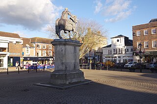
Hindhead is a village in the Waverley district of the ceremonial county of Surrey, England. It is the highest village in the county and its buildings are between 185 metres (607 ft) and 253 metres (830 ft) above sea level. The village forms part of the Haslemere parish. Situated on the county border with Hampshire, it is best known as the location of the Devil's Punch Bowl, a beauty spot and site of special scientific interest.

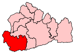
The Borough of Waverley is a local government district with borough status in Surrey, England. The borough contains the towns of Godalming, Farnham and Haslemere, as well as numerous villages, including the large village of Cranleigh, and surrounding rural areas. At the 2021 Census, the population of the borough was 128,200. The borough is named after Waverley Abbey, near Farnham. Large parts of the borough are within the Surrey Hills National Landscape. Its council, Waverley Borough Council, is based in Godalming.

The town of Haslemere and the villages of Shottermill and Grayswood are in south west Surrey, England, around 38 mi (62 km) south west of London. Together with the settlements of Hindhead and Beacon Hill, they comprise the civil parish of Haslemere in the Borough of Waverley. The tripoint between the counties of Surrey, Hampshire and West Sussex is at the west end of Shottermill.
East Hampshire is a local government district in Hampshire, England. Its council is based in the town of Petersfield, although the largest town is Alton. The district also contains the town of Bordon along with many villages and surrounding rural areas.

Liphook is a village in the East Hampshire district of Hampshire, England. It is 4.1 miles (6.6 km) west of Haslemere, bypassed by the A3 road, and lies on the Hampshire/West Sussex/Surrey borders. It is in the civil parish of Bramshott and Liphook, which includes Bramshott, Griggs Green, Conford, Passfield, Hammer Bottom, Ludshott Common and Waggoners Wells, and has an area of 6,540 acres (2,650 ha) and a population of 8,491 in 2011.
Delta FM was an Independent Local Radio station, broadcasting to East Hampshire, South West Surrey and North West Sussex. The station provided local news, community information, and specialist music programming to the towns of Alton, Bordon, Four Marks, Haslemere, Hindhead, Liphook, Midhurst and Petersfield.

Bordon is a town in the East Hampshire district of Hampshire, England. It lies in the interior of the royal Woolmer Forest, about 5 miles (8.0 km) southeast of Alton. The town forms a part of the civil parish of Whitehill which is one of two contiguous villages, the other being Lindford. The civil parish is on the A325, and near the A3 road between London and Portsmouth, from which it is buffered by the rise of the wooded Woolmer Ranges. Bordon is twinned with Condé-sur-Vire in Normandy, France.

Headley is a village, civil parish and Anglican parish in the East Hampshire district of Hampshire, England. It is 1.8 miles (2.9 km) east of Bordon on the B3002 road.
South West Surrey was a constituency in the House of Commons of the UK Parliament. Since its 1983 creation, South West Surrey has been represented only by members of the Conservative Party. From 2005, the seat's MP was Jeremy Hunt, who served as chancellor of the Exchequer until 2024, and the former Culture Secretary, Health Secretary and Foreign Secretary.

North East Hampshire is a constituency represented in the House of Commons of the UK Parliament by Alex Brewer, a Liberal Democrat.
The ceremonial county of Hampshire, which includes the unitary authorities of Portsmouth and Southampton, is divided into 19 parliamentary constituencies: 9 borough constituencies and 10 county constituencies. One of the county constituencies, Farnham and Bordon is split between Hampshire and Surrey
The ceremonial county of Surrey is divided into 11 parliamentary constituencies which are wholly within the county boundaries. In addition, there are two constituencies which cross the county boundary - one with Hampshire and one with Berkshire (Windsor). These thirteen seats are sub-classified into three of borough type and ten of county status, affecting the level of expenses permitted and the status of the returning officer.

East Hampshire is a constituency represented in the House of Commons of the UK Parliament since 2010 by Damian Hinds of the Conservative Party.

Grayshott is a village and civil parish in the East Hampshire district of Hampshire, England. It is on the Hampshire / Surrey border 4 miles (6.4 km) northwest of Haslemere by road, and 46 miles (74 km) southwest of central London. The nearest rail link is Haslemere railway station.

Bramshott is a village and parish with mediaeval origins in the East Hampshire district of Hampshire, England. It lies 0.9 miles (1.4 km) north of Liphook, and with Liphook forms the civil parish of Bramshott and Liphook.
The GU postcode area, also known as the Guildford postcode area, is a group of 38 postcode districts in South East England, within 24 post towns. These cover west Surrey, north-east Hampshire, northwestern West Sussex and a small part of south-east Berkshire.

The River Wey is a main tributary of the River Thames in south east England. Its two branches, one of which rises near Alton in Hampshire and the other in West Sussex to the south of Haslemere, join at Tilford in Surrey. Once combined, the flow is eastwards then northwards via Godalming and Guildford to meet the Thames at Weybridge. Downstream the river forms the backdrop to Newark Priory and Brooklands. The Wey and Godalming Navigations were built in the 17th and 18th centuries, to create a navigable route from Godalming to the Thames.

Headley Down is a village within the civil parish of Headley in the East Hampshire district of Hampshire, England, bounded on two sides by Ludshott Common, a National Trust heathland reserve. The village began with a few buildings in the 1870s and became a thriving community that in the 20th century outgrew the parish centre of Headley.

Whitehill is a village and civil parish in the East Hampshire district of Hampshire, England, on the historic route between Petersfield and Farnham. It is 0.7 miles (1.1 km) south of Bordon and covers an area of approximately 8 square miles.

Godalming and Ash is a constituency represented in the House of Commons of the UK Parliament that was first contested at the 2024 general election. It was created as a result of the 2023 review of Westminster constituencies.

