Related Research Articles

Omagh is the county town of County Tyrone, Northern Ireland. It is situated where the rivers Drumragh and Camowen meet to form the Strule. Northern Ireland's capital city, Belfast, is 68 miles (109.5 km) to the east of Omagh, and Derry is 34 miles (55 km) to the north.

Donemana or Dunnamanagh is a village in County Tyrone, Northern Ireland. It is 7 miles or 11 kilometres north-east of Strabane, on the banks of the Burn Dennett and at the foothills of the Sperrins. In 2001, it was the largest of the thirteen villages in the former Strabane District Council area and it had a population of 586 in the Census that year.

Caledon is a small village and townland in County Tyrone, Northern Ireland. It is in the Clogher Valley on the banks of the River Blackwater, 10 km from Armagh. It lies in the southeast of Tyrone and near the borders of County Armagh and County Monaghan. It is situated in the historic barony of Dungannon Lower and the civil parish of Aghaloo. In the 2001 Census it had a population of 387 people. It is a designated conservation area. It was historically known as Kinnaird.

Ardstraw is a small village, townland and civil parish in County Tyrone, Northern Ireland, three miles northwest of Newtownstewart. In the 2001 Census it had a population of 222 people.
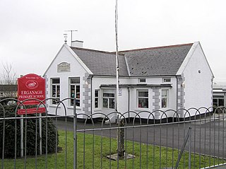
Erganagh is a small village and townland near Castlederg in County Tyrone, Northern Ireland. It is situated in the historic barony of Strabane Lower and the civil parish of Ardstraw. In the 2001 Census it had a population of 366 people. It is within the Strabane District Council area.

Evish is a small rural community area and townland in County Tyrone, Northern Ireland, 3 miles from Strabane and 7 miles from Plumbridge. It is situated in the barony of Strabane Lower and the civil parish of Camus and covers an area of 870 acres.

Killyman is a small village and a civil parish in Northern Ireland, situated on the eastern boundary of County Tyrone and extending into County Armagh. The majority of townlands are in the historic barony of Dungannon Middle in County Tyrone, the rest being in the barony of Oneilland West in County Armagh.

Carnteel ) is a hamlet, townland and civil parish, about 2 miles northeast of Aughnacloy in County Tyrone, Northern Ireland. It is situated in the historic barony of Dungannon Lower.

Liscloon is a settlement in County Tyrone, Northern Ireland. It is situated 2 miles from Donemana and 7 miles from Claudy. The area is sparsely populated although around 80 people reside in Liscloon. Altnachree Castle, also known as Liscloon House and Ogilby's Castle, still stands in Liscloon today. It was built in 1860 by William Ogilby.
Altishane or Altishahane is a small settlement and townland in County Tyrone, Northern Ireland. It lies near Strabane, between Plumbridge and Donemana. It is situated in the historic barony of Strabane Lower and the civil parish of Donaghedy and covers an area of 744 acres. There is one primary school, Altishane Primary School.

Urney is a townland and civil parish in County Tyrone, Northern Ireland. Both townland and parish are situated in the historic barony of Strabane Lower. It lies within the Derry City and Strabane area.
Killeeshil is a townland and civil parish in County Tyrone, Northern Ireland. It is situated in the historic barony of Dungannon Lower. Killeeshil is home to their local community centre which helps the local community throughout killeeshil parish. They work with trustees but mainly volunteer work.

Bockets is a townland in County Tyrone, Northern Ireland. It is situated in the historic barony of Dungannon Lower and the civil parish of Killeeshil and covers an area of 667 acres (270 ha).
Cranlome is a townland in County Tyrone, Northern Ireland. It is situated in the historic barony of Dungannon Lower and the civil parish of Killeeshil and covers an area of 1,259 acres (509 ha).
Lurgacullion is a townland in County Tyrone, Northern Ireland. It is situated in the historic barony of Dungannon Lower and the civil parish of Killeeshil and covers an area of 289 acres (117 ha).
Tullyvannon is a townland in County Tyrone, Northern Ireland. It is situated in the historic barony of Dungannon Lower and the civil parish of Killeeshil and covers an area of 448 acres.

Mullyroddan is a townland in County Tyrone, Northern Ireland. It is situated in the historic barony of Dungannon Lower and the civil parish of Killeeshil and covers an area of 308 acres (125 ha).

Dergenagh is a townland in County Tyrone, Northern Ireland. It is situated in the historic barony of Dungannon Lower and the civil parish of Killeeshil and covers an area of 437 acres (177 ha).

Aghaginduff is a townland in County Tyrone, Northern Ireland. It is situated in the historic barony of Dungannon Lower and the civil parish of Killeeshil and covers an area of 512 acres (207 ha). Aghaginduff is located approximately 12 km (7 mi) west of Dungannon, close to Cabragh.

Glencull is a townland in County Tyrone, Northern Ireland. It is situated in the historic barony of Dungannon Lower and the civil parish of Killeeshil and covers an area of 241 acres (98 ha). It is the only exclave of Killeeshil.
References
- ↑ "Farriter". Place Names NI. Retrieved 12 May 2015.
- ↑ "Farriter". IreAtlas Townlands Database. Retrieved 12 May 2015.
| | This article related to the geography of County Tyrone, Northern Ireland is a stub. You can help Wikipedia by expanding it. |