
The Ozark – St. Francis National Forest is a United States National Forest that is located in the state of Arkansas. It is composed of two separate forests, Ozark National Forest in the Ozark Mountains; and St. Francis National Forest on Crowley's Ridge. Each forest has distinct biological, topographical, and geological differences.
The Henry Shaw Ozark Corridor is a long string of adjoining conservation areas in the US state of Missouri, running 24 miles along Interstate 44 and 40 miles along the Meramec River. The corridor is named after Henry Shaw, founder of the Missouri Botanical Garden.

The Ozark Trail is a hiking, backpacking, and, in many places, biking and equestrian trail under construction in the Missouri Ozarks in the United States. It is intended to reach from St. Louis to Arkansas. Over 350 miles (563 km) of the trail have been completed as of 2008, and the estimated length when finished will be at least 500 miles (805 km). When joined to the Ozark Highlands Trail in Arkansas, the full hiking distance from end to end will be at least 700 miles (1,127 km), not including a large loop through the St. Francois Mountains in Missouri.

Mark Twain National Forest (MTNF) is a U.S. National Forest located in the southern half of Missouri. MTNF was established on September 11, 1939. It is named for author Mark Twain, a Missouri native. The MTNF covers 3,068,800 acres (12,419 km2) of which 1,506,100 acres (6,095 km2) is public owned, 78,000 acres (320 km2) of which are Wilderness, and National Scenic River area. MTNF spans 29 counties and represents 11% of all forested land in Missouri. MTNF is divided into six distinct ranger districts: Ava-Cassville-Willow Springs, Eleven Point, Houston-Rolla, Cedar Creek, Poplar Bluff, Potosi-Fredericktown, and the Salem. The six ranger districts actually comprise nine overall unique tracts of forests. Its headquarters are in Rolla, Missouri.

The United States Congress designated the Bell Mountain Wilderness in 1980. The wilderness area now has a total of 9,027 acres (36.53 km2). Bell Mountain is located within the Potosi-Fredericktown Ranger District of the Mark Twain National Forest, south of Potosi, Missouri in the United States. The wilderness lies in the Saint Francois Mountains and it was named after its highest point, Bell Mountain. The namesake Bell Mountain has the name of Henry Bell, a pioneer settler. The Bell Mountain Wilderness is one of eight wilderness areas protected and preserved in Missouri. The area is popular for hiking as there are 12 miles (19 km) of trail, including a section of the Ozark Trail.
French Creek State Park is a 7,526-acre (3,046 ha) Pennsylvania state park in North Coventry and Warwick Townships in Chester County and Robeson and Union Townships in Berks County, Pennsylvania in the United States. It straddles northern Chester County and southern Berks County along French Creek. It is located in the Hopewell Big Woods. The park is the home of two lakes: Hopewell Lake, a 68-acre (28 ha) warm water lake, and Scotts Run Lake, a 22-acre (8.9 ha) cold water lake. The state record smallmouth bass was caught in Scotts Run Lake. There are extensive forests, and almost 40 miles (64 km) of hiking and equestrian trails. The park is also friendly to mountain bikers, having some renowned technical trails. Hopewell Furnace National Historic Site, which features a cold blast furnace restored to its 1830s appearance, is surrounded by the park. The Six Penny Day Use Area and Group Camp are listed on the National Register of Historic Places. French Creek State Park is located off of Pennsylvania Route 345 to the south of Birdsboro.

Taum Sauk Mountain State Park is a Missouri state park located in the St. Francois Mountains in the Ozarks. The park encompasses Taum Sauk Mountain, the highest point in the state. The Taum Sauk portion of the Ozark Trail connects the park with nearby Johnson's Shut-ins State Park and the Bell Mountain Wilderness Area, which together are part of a large wilderness area popular with hikers and backpackers.

Sam A. Baker State Park is a public recreation area encompassing 5,323 acres (2,154 ha) in the Saint Francois Mountains region of the Missouri Ozarks. The state park offers fishing, canoeing, swimming, camping, and trails for hiking and horseback riding. The visitor and nature center is housed in a historic building that was originally constructed as a stable in 1934.

The Roger Pryor Pioneer Backcountry is a 60,000-acre (243 km2) area of private land that is managed by the Missouri Department of Natural Resources for hiking and backpacking by the public. The land is part of the largest private forest in the state, the Pioneer Forest, owned by the L-A-D Foundation, an endowment of the late Missouri timber magnate, conservationist, and philanthropist Leo Drey (1917–2015).

Devil's Den State Park is a 2,500-acre (1,000 ha) Arkansas state park in Washington County, near West Fork, Arkansas in the United States. The park was built by the Civilian Conservation Corps, beginning in 1933. Devil's Den State Park is in the Lee Creek Valley in the Boston Mountains, which are the southwestern part of The Ozarks. The park, with an 8 acres (3.2 ha) CCC-built lake, is open for year-round recreation, with trails for hiking, mountain biking and horseback riding. Devil's Den State Park also has several picnic areas, a swimming pool and cabins, with camping sites ranging from modern to primitive. Fossils of coral and crinoids can be found along the banks and within Lee Creek at Devil's Den State Park.

August A. Busch Memorial Conservation Area is a 6,987-acre (28.28 km2) conservation area that is owned and managed by the Missouri Department of Conservation. Located in St. Charles County, Missouri, the land was purchased by the Department of Conservation with help from Alice Busch, the wife of August Anheuser Busch, Sr., in 1947 from the U.S. Government.

The Weldon Spring Conservation Area, is a 8,398-acre (33.99 km2) conservation area that is owned and managed by the Missouri Department of Conservation and located in St. Charles County, Missouri. The area borders the Missouri River, and the Katy Trail runs through the area but is not considered part of the conservation area.

Rockwoods Range Conservation Area consists of 1,388 acres (5.62 km2) in western St. Louis County, Missouri. It is just north of Interstate 44 west of Eureka. The land is part of the Henry Shaw Ozark Corridor.

LaBarque Creek Conservation Area (LCCA) consists of 1,274 acres (5.16 km2) in northwestern Jefferson County, Missouri. It is south of Pacific and southwest of Eureka. The LCCA is part of the Henry Shaw Ozark Corridor. The Young Conservation Area is about 2 miles (3.2 km) to the east, Myron and Sonya Glassberg Family Conservation Area is 1.2 mi (1.9 km) to the northeast, Pacific Palisades Conservation Area is 3.3 miles (5.3 km) to the north, Catawissa Conservation Area is 3.5 miles (5.6 km) northwest, and Robertsville State Park is 4.7 miles (7.6 km) west.

Emmenegger Nature Park (ENP) consists of 93 acres (0.38 km2) in southwestern St. Louis County, Missouri. It is located in the city of Kirkwood and bordered to the west by the Meramec River, to the south by Interstate 44 and the Possum Woods Conservation Area, and to the east by Interstate 270. The ENP is part of the Henry Shaw Ozark Corridor. The Powder Valley Nature Center is directed the east of ENP across Interstate 270.

Allenton Access is a protected nature area consisting of 9 acres (0.036 km2) in western St. Louis County, Missouri. It is located southwest of the town of Eureka, east of the town of Pacific and bordered to the south by the Meramec River. It is part of the Meramec Greenway and Henry Shaw Ozark Corridor.

Possum Woods Conservation Area consists of 15 acres (0.061 km2) in St. Louis County, Missouri. It is located in the city of Kirkwood at the intersection of Interstates 44 and 270. It is adjacent to Emmenegger Nature Park along the Meramec River and part of the Meramec Greenway and Henry Shaw Ozark Corridor.
Myron and Sonya Glassberg Family Conservation Area is a 429-acre (1.74 km2) protected area in northwestern Jefferson County, Missouri. It is south of Eureka and southeast of Pacific. The Glassberg Family Conservation Area is located within the watershed of the Meramec River, primarily in the watershed of LaBarque Creek. The Young Conservation Area is about 0.2 miles (0.32 km) to the east and LaBarque Creek Conservation Area is about 1.2 miles (1.9 km) to the southwest.
Greensfelder County Park consists of 1,734 acres (7.02 km2) in western St. Louis County, Missouri. It is located in the city of Wildwood and bordered to the south by the Eureka and Six Flags St. Louis. Greensfelder is part of the Henry Shaw Ozark Corridor. The park's land was donated to St. Louis County in 1963 by the trustees of the St. Louis Regional Planning and Construction Foundation, which had been established in 1939 by Albert P. Greensfelder. The park was originally named Rockwood Park, but was renamed in 1965 in honor of A.P. Greensfelder.
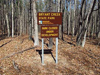
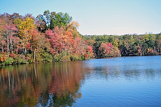
Bryant Creek State Park is one of three new Missouri state parks announced in 2016. The 2,917-acre (1,180 ha) property is located along Bryant Creek in south central Douglas County, 22 miles (35 km) southeast of Ava in the Ozarks of southern Missouri. The park is closed and awaiting development.


 Williams Creek
 Losing Stream Trail
 Williams Creek

