Fort Garland, Colorado

Last updated
Fort Garland, Colorado
Fort Garland, Colorado.JPG
Fort Garland from the south.
Costilla County Colorado Incorporated and Unincorporated areas Fort Garland Highlighted.svg
Location of the Fort Garland CDP in Costilla County, Colorado.
Usa edcp relief location map.png
Red pog.svg
Fort Garland
Location of the Fort Garland CDP, Colorado.
USA Colorado relief location map.svg
Red pog.svg
Fort Garland
Fort Garland (Colorado)
Coordinates: 37°25′44″N105°26′02″W / 37.4289°N 105.4339°W / 37.4289; -105.4339 (Fort Garland, Colorado) [1]
Country United States
State Colorado
County Costilla [2]
Established1858
Government
  Type unincorporated community
  Body Costilla County [2]
Area
[3]
  Total
0.376 sq mi (0.973 km2)
  Land0.376 sq mi (0.973 km2)
  Water0 sq mi (0 km2)
Elevation
[1]
7,943 ft (2,421 m)
Population
 (2020) [4]
  Total
464
  Density1,240/sq mi (477/km2)
Time zone UTC−07:00 (MST)
  Summer (DST) UTC−06:00 (MDT)
ZIP code [5]
81133
Area code 719
GNIS place ID 192831
GNIS town ID 2408238
FIPS code 08-27535

Fort Garland was a United States Army post from 1858 to 1883. Today, Fort Garland is a historic unincorporated community, a post office, and a census-designated place (CDP) located in and governed by Costilla County, Colorado, United States. At the United States Census 2020, the population of the Fort Garland CDP was 464, [4] while the population of the 81133 ZIP Code Tabulation Area was 840 including adjacent areas. [6] The Fort Garland post office has the ZIP Code 81133. [5] Fort Garland is a part of the Alamosa, CO Micropolitan Statistical Area.

Contents

History

Fort Garland was established by the United States Army in June 1858 to protect white settlers from the Ute people in the San Luis Valley, which was then part of the New Mexico Territory. Fort Garland was built to replace the earlier Fort Massachusetts. The new Territory of Colorado was organized on February 28, 1861, and the Fort Garland, Colorado Territory, post office opened on February 25, 1862. [7] The fort was abandoned in 1883 following the confinement of the tribes to Indian reservations in the Territory of Utah and the State of Colorado. The Fort Garland Museum preserves some of the historic buildings from the fort. [8]

Geography

Mount Lindsey and Iron Nipple, Sangre de Cristo Range, taken from along C-159, about five miles south of Fort Garland Mount Lindsey and Iron Nipple.jpg
Mount Lindsey and Iron Nipple, Sangre de Cristo Range, taken from along C-159, about five miles south of Fort Garland

Fort Garland is located in northern Costilla County at coordinates 37°25′44″N105°26′02″W / 37.4289°N 105.4339°W / 37.4289; -105.4339 (Fort Garland, Colorado) and elevation 7,943 feet (2,421 m). [1] Fort Garland is located at the crossroads of U.S. Route 160 and Colorado State Highway 159, which leads south towards Taos and Santa Fe, New Mexico. The town of Blanca is 4 miles (6.4 km) west on U.S. Route 160. Walsenburg is 47 miles (76 km) to the east, across the Sangre de Cristo Range.

At the 2020 United States Census, the Fort Garland CDP had an area of 240 acres (0.973 km2), all land. [3]

Demographics

The United States Census Bureau initially defined the Fort Garland CDP for the United States Census 2000.

Fort Garland CDP, Colorado
YearPop.±%
2000 432    
2010 433+0.2%
2020 464+7.2%
Source: United States Census Bureau

Economy

Ute Cafe in Fort Garland Wagon and sign for the Ute Cafe in Fort Garland, Colorado LCCN2015632578.tif
Ute Cafe in Fort Garland

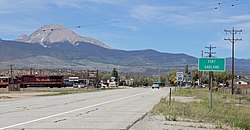
Fort Garland is referred to as the "Gateway to the San Luis Valley", as it is the first town one encounters when traveling west having crossed over La Veta Pass in the Sangre de Cristo Range. Fort Garland is home to many artists, painters, crafters and internationally known musicians.

Fort Garland has a business district with two motels, several restaurants, the Old Fort Market grocery store, the Fort Garland Museum, two gas stations, two recreational marijuana shops, a car wash, hair salon, campgrounds, hardware store, liquor store, and multiple shops featuring collectibles and antiquities as well as a Wild West show.

Arts and culture

The Annual Fort Garland Band Jam Music Festival features local and regional musicians, as well as nationally and internationally recognized musical talent. This summer event, usually held in mid-July, includes an open-air market, local food vendors offering up traditional and regional cuisine, a beer garden, and children's activities. The music offered covers numerous styles, from traditional Spanish guitar to R&B to rock and roll.

The Blanca/Fort Garland Community Center is open to residents and the public on daily, monthly or annual fees.

The Entrada Visitor Center offers information on local and regional points of interest, such as the Great Sand Dunes, the Colorado 'Gator farm, UFO Watchtower and other activities located within the San Luis Valley.

Infrastructure

The Fort Garland Water and Sanitation District provides services to residents. It has also provided water to the surrounding community who have cisterns. [9]

See also

References

  1. 1 2 3 "Fort Garland, Colorado". Geographic Names Information System . United States Geological Survey, United States Department of the Interior . Retrieved December 9, 2025.
  2. 1 2 "Colorado Counties". Colorado Department of Local Affairs . Retrieved December 9, 2025.
  3. 1 2 "State of Colorado Census Designated Places - BAS20 - Data as of January 1, 2020". United States Census Bureau . Retrieved December 21, 2020.
  4. 1 2 United States Census Bureau. "Fort Garland CDP, Colorado" . Retrieved April 2, 2023.
  5. 1 2 "ZIP Code Lookup". United States Postal Service . Retrieved December 9, 2025.
  6. "2010: DEC Summary File 1". United States Census Bureau . Retrieved December 21, 2020.
  7. Bauer, William H.; Ozment, James L.; Willard, John H. (1990). Colorado Post Offices 1859–1989. Golden, Colorado: Colorado Railroad Historical Foundation. ISBN   0-918654-42-4.
  8. "Fort Garland". Archived from the original on 2017-09-29. Retrieved 2010-09-19.
  9. Brown, Jennifer (2025-08-25). "Hundreds lose water source in Colorado's poorest county with no notice, no warning". The Colorado Sun.