Davis Peak is a mountain just north of Gorge Lake in North Cascades National Park, in the US state of Washington. It is located just south of the Picket Range. While not of particularly high elevation, even for the North Cascades, it is notable for its large, steep local relief, and in particular for its huge Northeast Face, which drops 5,250 ft (1,600 m) in one horizontal mile (1.6 km). This is one of the two largest vertical drops in one horizontal mile in the contiguous United States, the other being the North Face of Kinnerly Peak.

Bacon Peak is a mountain located in North Cascades National Park, in the Cascade Range in the U.S. state of Washington. Its glaciers cover 1.2 square miles (3.2 km2); the three main glaciers are Diobsud Creek Glacier, Green Lake Glacier and Noisy Creek Glacier.
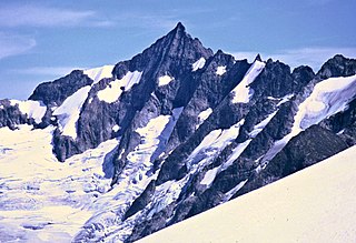
Forbidden Peak is an 8,815 feet (2,687 m) glacial horn located in North Cascades National Park, in Skagit County of Washington state. It is part of the North Cascades and is located near Cascade Pass. Forbidden Peak features a rock climbing route named West Ridge route which is featured in Fifty Classic Climbs of North America. The peak was first climbed by a party consisting of Fred Beckey, his brother Helmy Beckey, Jim Crooks, Lloyd Anderson and Dave Lind in 1940.

Sinister Peak is in Mount Baker-Snoqualmie and Wenatchee National Forests in the U.S. state of Washington. It is situated in Glacier Peak Wilderness and the North Cascades. Not quite 1 mi (1.6 km) east of Dome Peak, Sinister Peak is along a high ridge connecting the two peaks. The Chickamin Glacier is on the north slopes of Sinister Peak while the Garden Glacier is just southeast. Though some of the routes to the summit are technical, it can be reached by a moderate scramble.

Whatcom Peak is in North Cascades National Park in the U.S. state of Washington. Whatcom Peak is .50 mi (0.80 km) north of Challenger Glacier and the Whatcom Glacier descends from the northeast slopes of the peak. An unnamed hanging glacier descends along the northwest flank of the peak. This mountain is set between Mount Challenger and Easy Peak.
Mesahchie Peak is in North Cascades National Park in the U.S. state of Washington. Mesahchie Peak is named after the Chinook word for wicked. Mesahchie Peak is the highest summit along a ridge known as Ragged Ridge and is only .25 mi (0.40 km) east of Katsuk Peak. Both the Katsuk and Mesahchie Glaciers descended down the northwest and northeast flanks of the peak respectively.

Big Kangaroo is an 8,326-foot (2,538-metre) mountain summit in Okanogan County, Washington, United States.

Cutthroat Peak is an 8,066-foot-elevation (2,459-meter) granitic mountain located on the boundary of Chelan County and Skagit County, in Washington state. The mountain is part of the Okanagan Range which is a subrange of the Cascade Range, and it is situated within the Okanogan–Wenatchee National Forest. Cutthroat Peak is set about two miles west of Washington Pass and one mile east of Rainy Pass. It is a prominent landmark along the North Cascades Highway with an accessible climbing route. Topographic relief is significant as the summit rises over 3,000 feet above State Creek in one mile (1.6 km). There is also a Cutthroat Lake, Cutthroat Creek, and Cutthroat Pass on its north and east aspects. This landform's toponym was officially adopted in 1988 by the United States Board on Geographic Names. Molar Tooth is a granite pillar half a mile north on the ridge extending to Cutthroat Pass.

Whistler Mountain is a 7,790-foot (2,370-metre) mountain summit located in Chelan County of Washington state. The mountain is part of the Okanagan Range which is a sub-range of the North Cascades. Whistler Mountain is about two miles west of Washington Pass and one mile east of Rainy Pass. The North Cascades Highway bends around the southern base of the mountain between these two passes. A high ridge connects Whistler to its nearest higher neighbor, Cutthroat Peak, which is 0.78 miles (1.26 km) to the north-northeast. Precipitation runoff from the peak drains into Bridge Creek. Topographic relief is significant as the summit rises over 3,000 feet above the creek and highway in approximately one mile.

Fisher Peak is an 8,087-foot-elevation (2,465-meter) mountain summit located in the North Cascades of Washington state. It is situated on the boundaries of the Stephen Mather Wilderness and North Cascades National Park, midway between Black Peak and Easy Pass, and adjacent to Repulse Peak. Precipitation runoff from Fisher Peak's north and east slopes drains to Fisher Creek and Granite Creek which flow to the Skagit River, whereas the west slope drains into tributaries of the Stehekin River. Topographic relief is significant as the east aspect rises approximately 2,100 feet in less than one-half mile (0.8 km). The mountain's toponym has been officially adopted by the United States Board on Geographic Names.

Paul Bunyans Stump is a 7,513 ft (2,290 m) mountain summit in the North Cascades Range of Washington, United States. It is located within North Cascades National Park. It rises steeply from Diablo Lake, one of the reservoirs on the Skagit River. It is part of a group of peaks that form the northern end of a chain running south through climbing destinations such as Colonial Peak and Snowfield Peak. The nearest peak to Paul Bunyans Stump is Pinnacle Peak, 0.37 mi (0.60 km) to the north, and the nearest higher peak is Neve Peak, 0.9 mi (1.4 km) to the southeast. Like many North Cascade peaks, Paul Bunyans Stump is more notable for its large, steep rise above local terrain than for its absolute elevation. Precipitation runoff from the mountain drains into Diablo Lake and Skagit River.

Icy Peak is a 7,073-foot (2,156-metre) Skagit Range mountain summit located in the North Cascades of Washington state. It is situated in North Cascades National Park at the head of Nooksack Cirque. High ridges connect it to Seahpo Peak and Mount Shuksan. An icefall occupies the northeast cirque, and small glaciers clad all sides of the peak. Precipitation runoff drains into the Nooksack and Baker Rivers.

The Roost is a 6,705 ft summit in the Picket Range which is a sub-range of the North Cascades of Washington, United States. It is located within North Cascades National Park and Stephen Mather Wilderness, and it is situated one mile north of Mount Ross. Like many North Cascades peaks, The Roost is more notable for its large, steep rise above local terrain than for its absolute elevation. The Roost was first climbed on July 12, 1966 by John and Taffy Roper. The nearest higher neighbor is Glee Peak, 1.76 miles (2.83 km) to the north. Precipitation runoff from the mountain drains into the Skagit River.
Porcupine Peak is a 7,762-foot-elevation (2,366-meter) mountain located in Skagit County of Washington state.

Rainy Peak is a 7,768 ft (2,368 m) summit in the Cascade Range in the U.S. state of Washington. It is located 3 kilometers south of Rainy Pass and one kilometer southeast of Frisco Mountain on the borders of the Stephen Mather Wilderness and North Cascades National Park. Its nearest higher peak is Corteo Peak, 2.33 mi (3.75 km) to the northwest. Precipitation runoff from Rainy Peak drains into Rainy Lake and tributaries of Bridge Creek. The retreating Lyall Glacier in its north cirque contributes to waterfalls which tumble 1,000 ft (300 m) into Rainy Lake.
Molar Tooth is a 7,547-foot-elevation (2,300-meter) granite summit located on the shared border of Okanogan County and Skagit County, in Washington state. The mountain is part of the Okanagan Range which is a subrange of the Cascade Range. Set in the Okanogan–Wenatchee National Forest, Molar Tooth is situated south of Cutthroat Pass, and 0.57 miles (0.92 km) north of Cutthroat Peak, which is also the nearest higher peak. The easiest climbing route is class 4 scrambling, but solid rock provides class 5 technical routes as well. Precipitation runoff from the east side of Molar Tooth drains into tributaries of the Methow River, whereas runoff from the west side drains into tributaries of the Skagit River.

Mineral Mountain is a 6,800-foot (2,100-metre) mountain summit in the Skagit Range of the North Cascades of Washington state. Mineral Mountain is situated in North Cascades National Park and the summit offers views of Mount Shuksan, Icy Peak, and the Picket Range. Easy Peak is set 2 mi (3.2 km) to the east, and the nearest higher neighbor is Ruth Mountain, 3.06 mi (4.92 km) to the west. Precipitation runoff from Mineral Mountain finds its way north into the Chilliwack River, and south into the Baker River.

Pinnacle Peak is a 7,386 ft (2,251 m) mountain summit in the North Cascades Range of Washington, United States. It is located within North Cascades National Park, between Pyramid Peak and Paul Bunyans Stump, which is the nearest higher peak. It rises steeply from Diablo Lake, one of the reservoirs on the Skagit River. It is part of a group of peaks that form the northern end of a chain running south through climbing destinations such as Colonial Peak and Snowfield Peak. Like many North Cascade peaks, Pinnacle Peak is more notable for its large, steep rise above local terrain than for its absolute elevation. Precipitation runoff from the mountain drains into Diablo Lake and Skagit River. The approach is via the Pyramid Lake Trail, starting near Diablo Dam on the North Cascades Highway. From the lake, there is route-finding up Pyramid Arm to Colonial Glacier.

Wallaby Peak is a 7,995-foot (2,437-metre) mountain summit located on the boundary line of the Lake Chelan-Sawtooth Wilderness, in Okanogan County, Washington. The mountain is part of the Methow Mountains, which are a subset of the Cascade Range. Wallaby Peak is situated on Kangaroo Ridge which is approximately two miles east and within view of Washington Pass. The nearest higher peak is Big Kangaroo, 0.86 mi (1.38 km) to the north. Precipitation runoff from the peak drains into Early Winters Creek, Cedar Creek, and North Fork Twisp River, all of which are tributaries of the Methow River.

Half Moon is a 7,960+ ft summit located in Okanogan–Wenatchee National Forest, in Okanogan County, of Washington state. The mountain is part of the Methow Mountains, which are a subset of the Cascade Range. Half Moon is situated on Kangaroo Ridge which is approximately two miles east and within view of the North Cascades Highway at Washington Pass. The nearest higher neighbor is Wallaby Peak, 0.23 mi (0.37 km) to the south. Precipitation runoff from the peak drains into Early Winters Creek, and Cedar Creek, both of which are tributaries of the Methow River.