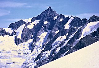
Forbidden Peak is an 8,815 feet (2,687 m) glacial horn located in North Cascades National Park, in Skagit County of Washington state. It is part of the North Cascades and is located near Cascade Pass. Forbidden Peak features a rock climbing route named West Ridge route which is featured in Fifty Classic Climbs of North America. The peak was first climbed by a party consisting of Fred Beckey, his brother Helmy Beckey, Jim Crooks, Lloyd Anderson and Dave Lind in 1940.

Big Kangaroo is an 8,326-foot (2,538-metre) mountain summit in Okanogan County, Washington, United States.

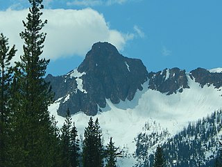
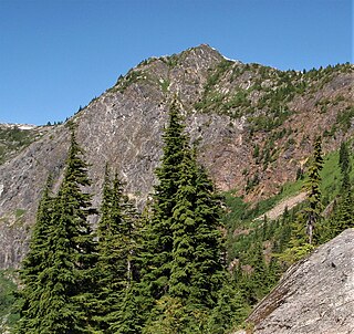
Cutthroat Peak is an 8,066-foot-elevation (2,459-meter) granitic mountain located on the boundary of Chelan County and Skagit County, in Washington state. The mountain is part of the Okanagan Range which is a subrange of the Cascade Range, and it is situated within the Okanogan–Wenatchee National Forest. Cutthroat Peak is set about two miles west of Washington Pass and one mile east of Rainy Pass. It is a prominent landmark along the North Cascades Highway with an accessible climbing route. Topographic relief is significant as the summit rises over 3,000 feet above State Creek in one mile (1.6 km). There is also a Cutthroat Lake, Cutthroat Creek, and Cutthroat Pass on its north and east aspects. This landform's toponym was officially adopted in 1988 by the United States Board on Geographic Names. Molar Tooth is a granite pillar half a mile north on the ridge extending to Cutthroat Pass.

Hinkhouse Peak is a 7,566-foot-elevation (2,306-meter) mountain summit located on the shared border of Okanogan County and Chelan County in Washington state. It is part of the Okanogan Range which is a sub-range of the North Cascades Range. Hinkhouse Peak is situated on land administered by the Okanogan–Wenatchee National Forest. The nearest higher neighbor is Liberty Bell Mountain, 1.52 miles (2.45 km) to the south. Hinkhouse Peak is situated north of Washington Pass, at the east end of a high ridge which connects to Cutthroat Peak. A high ridge extending northeast connects it to Constitution Crags. Most precipitation runoff from the peak drains into Early Winters Creek which is a tributary of the Methow River, but the south slope drains into a tributary of the Chelan River. Topographic relief is significant as it rises nearly 3,200 feet above Early Winters Creek in approximately one mile (1.6 km).

Fisher Peak is an 8,087-foot-elevation (2,465-meter) mountain summit located in the North Cascades of Washington state. It is situated on the boundaries of the Stephen Mather Wilderness and North Cascades National Park, midway between Black Peak and Easy Pass, and adjacent to Repulse Peak. Precipitation runoff from Fisher Peak's north and east slopes drains to Fisher Creek and Granite Creek which flow to the Skagit River, whereas the west slope drains into tributaries of the Stehekin River. Topographic relief is significant as the east aspect rises approximately 2,100 feet in less than one-half mile (0.8 km). The mountain's toponym has been officially adopted by the United States Board on Geographic Names.

Frisco Mountain is a 7,760-foot (2,365-metre) mountain summit in the Cascade Range in the U.S. state of Washington. It is located two miles southwest of Rainy Pass on the borders of the Stephen Mather Wilderness and North Cascades National Park. First climbed by surveyor Lage Wernstedt in 1926, the mountain derives its name from a mining claim on the south side that was worked in the 1920s. Its nearest higher peak is Rainy Peak, 0.54 mi (0.87 km) to the east-southeast. Precipitation runoff from Frisco Mountain drains into Rainy Lake and tributaries of Bridge Creek. The retreating Lyall Glacier in its northeast cirque contributes to waterfalls which tumble 1,000 ft (300 m) into Rainy Lake.
Kitling Peak is an 8,003-foot (2,439-metre) mountain summit in the North Cascades in the U.S. state of Washington. It is located one mile northwest of Easy Pass on the borders of the Stephen Mather Wilderness and North Cascades National Park. Kitling Peak is situated at the east end of Ragged Ridge. Other peaks on Ragged Ridge include Mesahchie Peak, Kimtah Peak, Katsuk Peak, and Graybeard Peak. The nearest higher peak is Mesahchie Peak, 0.95 miles (1.53 km) to the south. The Mesahchie Glacier on Kitling's northwest slope forms the headwaters of Panther Creek. Precipitation runoff on the east side of the mountain drains into Ross Lake via Granite Creek, whereas the west side of the peak drains into Diablo Lake via Panther Creek and Fisher Creek. Topographic relief is significant as the summit rises 3,000 feet above Fisher Creek in one mile (1.6 km) and the northeast slope rises 3,400 feet above Kitling Creek in 0.75 mile (1.2 km). The mountain's name "Kitling" derives from Chinook Jargon "ketling" which means kettle. The mountain takes its name from Kitling Lake which is one mile north of the peak. The toponym was officially adopted in 1969 by the U.S. Board on Geographic Names.

Ruth Mountain is a 7,115 ft (2,170 m) Skagit Range summit located two miles south of Hannegan Pass in the North Cascades of Washington state. The name honors Ruth Cleveland, daughter of President Grover Cleveland. This mountain's name was officially adopted in 1952 by the United States Board on Geographic Names. Ruth Mountain is situated on the shared border of North Cascades National Park and the Mount Baker Wilderness, which is part of the Mount Baker-Snoqualmie National Forest. The summit offers views of Mount Shuksan, East Nooksack Glacier, Seahpo Peak, Nooksack Tower, Icy Peak, Mount Sefrit, Mineral Mountain, and the Picket Range. The melting and receding Ruth Glacier on the north slope of Ruth creates the headwaters for the Chilliwack River. Precipitation runoff also finds its way into the Nooksack and Baker Rivers.

The Roost is a 6,705 ft summit in the Picket Range which is a sub-range of the North Cascades of Washington, United States. It is located within North Cascades National Park and Stephen Mather Wilderness, and it is situated one mile north of Mount Ross. Like many North Cascades peaks, The Roost is more notable for its large, steep rise above local terrain than for its absolute elevation. The Roost was first climbed on July 12, 1966 by John and Taffy Roper. The nearest higher neighbor is Glee Peak, 1.76 miles (2.83 km) to the north. Precipitation runoff from the mountain drains into the Skagit River.
Porcupine Peak is a 7,762-foot-elevation (2,366-meter) mountain located in Skagit County of Washington state.

Rainy Peak is a 7,768 ft (2,368 m) summit in the Cascade Range in the U.S. state of Washington. It is located 3 kilometers south of Rainy Pass and one kilometer southeast of Frisco Mountain on the borders of the Stephen Mather Wilderness and North Cascades National Park. Its nearest higher peak is Corteo Peak, 2.33 mi (3.75 km) to the northwest. Precipitation runoff from Rainy Peak drains into Rainy Lake and tributaries of Bridge Creek. The retreating Lyall Glacier in its north cirque contributes to waterfalls which tumble 1,000 ft (300 m) into Rainy Lake.

Holliway Mountain is an 8000+ ft granite summit located in Okanogan County in Washington state. It is part of the Okanogan Range which is a sub-range of the North Cascades Range. Holliway Mountain is situated near the headwaters of the Methow River on land administered by the Okanogan–Wenatchee National Forest. The nearest higher peak is Golden Horn, 0.91 miles (1.46 km) to the south. Azurite Peak is located three miles to the north-northwest.
Molar Tooth is a 7,547-foot-elevation (2,300-meter) granite summit located on the shared border of Okanogan County and Skagit County, in Washington state. The mountain is part of the Okanagan Range which is a subrange of the Cascade Range. Set in the Okanogan–Wenatchee National Forest, Molar Tooth is situated south of Cutthroat Pass, and 0.57 miles (0.92 km) north of Cutthroat Peak, which is also the nearest higher peak. The easiest climbing route is class 4 scrambling, but solid rock provides class 5 technical routes as well. Precipitation runoff from the east side of Molar Tooth drains into tributaries of the Methow River, whereas runoff from the west side drains into tributaries of the Skagit River.

Constitution Crags is a 6,978-foot-elevation summit located in Okanogan County of Washington state. It is part of the Okanogan Range which is a sub-range of the North Cascades. Constitution Crags is situated west of Silver Star Mountain on land administered by the Okanogan–Wenatchee National Forest. The nearest higher neighbor is Hinkhouse Peak, 0.62 mile to the southwest. Washington Pass is located over a mile south of Constitution Crags, and the North Cascades Highway traverses below the east face of Constitution Crags. Like many North Cascade peaks, Constitution Crags is more notable for its large, steep rise above local terrain than for its absolute elevation. Topographic relief is significant as the summit rises nearly 2,700 feet above Early Winters Creek in approximately one mile (1.6 km). Precipitation runoff from the peak drains into Early Winters Creek which is a tributary of the Methow River.

Copper Benchmark, also known as Copper Point, is a 7,844-foot-elevation (2,391-meter) mountain summit located on the shared border between Okanogan County and Chelan County in Washington state. Copper Benchmark is part of the Methow Mountains which are a subrange of the North Cascades, and it is situated on the crest of the Cascade Range between Kangaroo Pass and Copper Pass. It was used as a triangulation station for early surveying. It is protected by the Lake Chelan-Sawtooth Wilderness within the Okanogan–Wenatchee National Forest. Copper Benchmark has a subsidiary peak, Pica Peak (elevation 7,565 feet, which is 0.52 miles northwest of the summit. The nearest higher peak is Wallaby Peak, 0.9 miles to the northeast. Precipitation runoff on the north side of the mountain drains to the Methow River via Early Winters Creek, whereas the other sides of the mountain drain into tributaries of the Chelan River.

Mineral Mountain is a 6,800-foot (2,100-metre) mountain summit in the Skagit Range of the North Cascades of Washington state. Mineral Mountain is situated in North Cascades National Park and the summit offers views of Mount Shuksan, Icy Peak, and the Picket Range. Easy Peak is set 2 mi (3.2 km) to the east, and the nearest higher neighbor is Ruth Mountain, 3.06 mi (4.92 km) to the west. Precipitation runoff from Mineral Mountain finds its way north into the Chilliwack River, and south into the Baker River.

Wallaby Peak is a 7,995-foot (2,437-metre) mountain summit located on the boundary line of the Lake Chelan-Sawtooth Wilderness, in Okanogan County, Washington. The mountain is part of the Methow Mountains, which are a subset of the Cascade Range. Wallaby Peak is situated on Kangaroo Ridge which is approximately two miles east and within view of Washington Pass. The nearest higher peak is Big Kangaroo, 0.86 mi (1.38 km) to the north. Precipitation runoff from the peak drains into Early Winters Creek, Cedar Creek, and North Fork Twisp River, all of which are tributaries of the Methow River.

Half Moon is a 7,960+ ft summit located in Okanogan–Wenatchee National Forest, in Okanogan County, of Washington state. The mountain is part of the Methow Mountains, which are a subset of the Cascade Range. Half Moon is situated on Kangaroo Ridge which is approximately two miles east and within view of the North Cascades Highway at Washington Pass. The nearest higher neighbor is Wallaby Peak, 0.23 mi (0.37 km) to the south. Precipitation runoff from the peak drains into Early Winters Creek, and Cedar Creek, both of which are tributaries of the Methow River.
Trappers Peak is a 5,966-foot (1,818 m) elevation mountain summit located in the North Cascades of Washington state. It is situated within North Cascades National Park, Stephen Mather Wilderness, and Whatcom County. It rises steeply above Lower Thornton Lake which is set at the southwestern face of the mountain. Like many North Cascades peaks, Trappers Peak is more notable for its large, steep rise above local terrain than for its absolute elevation. Topographic relief is significant as the southeast aspect rises 5,500 feet (1,700 m) above the North Cascades Highway in approximately two miles. The nearest higher neighbor is Thornton Peak, 1.5 miles (2.4 km) to the northwest, Mount Triumph is two miles to the northwest, and Newhalem is three miles to the east-southeast. Precipitation runoff from the mountain drains into tributaries of the Skagit River. The summit of Trappers Peak is known for its grand view of the jagged peaks of the Picket Range.

Damnation Peak is a 5,635-foot-elevation (1,718 m) mountain summit located in the North Cascades of Washington state. It is situated within North Cascades National Park, Stephen Mather Wilderness, and Whatcom County. Like many North Cascades peaks, Damnation Peak is more notable for its large, steep rise above local terrain than for its absolute elevation. Topographic relief is significant as the south aspect rises 2,800 feet above Damnation Creek in approximately 1.5 mile, and the north aspect rises 3,000 feet above Triumph Creek in one mile. Precipitation runoff from the mountain drains into these tributaries of the Skagit River. Neighbors include Mount Triumph, 2.8 miles (4.5 km) to the north-northeast, and Trappers Peak is 2.8 miles (4.5 km) to the east-northeast. The town of Newhalem is six miles to the east. In 1938, Lloyd Anderson climbed a nearby summit which is known today as Thornton Peak and called it "Damnation."


