
Stoney Creek is a community in the city of Hamilton in the Canadian province of Ontario. It was officially a city from 1984 to 2001, when it was amalgamated with the rest of the cities of the Regional Municipality of Hamilton–Wentworth.

Hamilton Mountain is a federal electoral district in Ontario, Canada, that has been represented in the House of Commons of Canada since 1968. The riding is located in the Hamilton region.

Westdale is a residential neighbourhood in Hamilton, Ontario, Canada. It is centred in the Westdale Village shopping district and located near McMaster University. It is bordered to the north by Cootes Paradise, an extensive nature reserve marking the western end of Lake Ontario, to the south by Main Street and Ainslie Wood, to the east by Highway 403, and to the west by McMaster University.
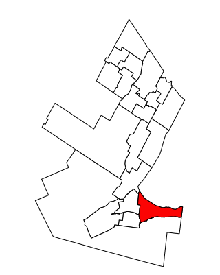
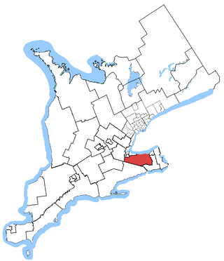
Hamilton East—Stoney Creek is a federal electoral district in Ontario, Canada, that has been represented in the House of Commons of Canada since 2004.
Niagara West—Glanbrook was a federal electoral district in Ontario, Canada, that existed from 2004 to 2015.
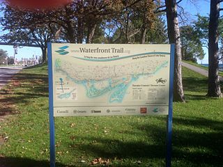
Stretching over 3600 km from Prince Township, west of Sault Ste. Marie, to the Quebec border, the Great Lakes Waterfront Trail is a signed route of interconnecting roads and off-road trails joining over 150 communities and First Nations along the Canadian shores of the Great Lakes and St. Lawrence River. A celebration of nature and culture, the Great Lakes Waterfront Trail is part of a strategy to protect and connect people to the largest group of freshwater lakes on earth. It is a legacy project of the Waterfront Regeneration Trust, a charity, and its community partners. Through Toronto, the trail is called the Martin Goodman Trail. The Waterfront Trail is also used by commuters in parts of Southern Ontario.

Binbrook is a community in southeastern Hamilton, Ontario, in Canada. It was amalgamated into the city of Hamilton in 2001. Since 2001, hundreds of new homes have been built in Binbrook, separated from Hamilton by conservation and agricultural lands.

Carlisle is a community in Flamborough, Hamilton, Ontario, Canada. The town lies about 15 kilometres (9.3 mi) north of Waterdown.
Millgrove is a small rural community in Ontario, Canada.
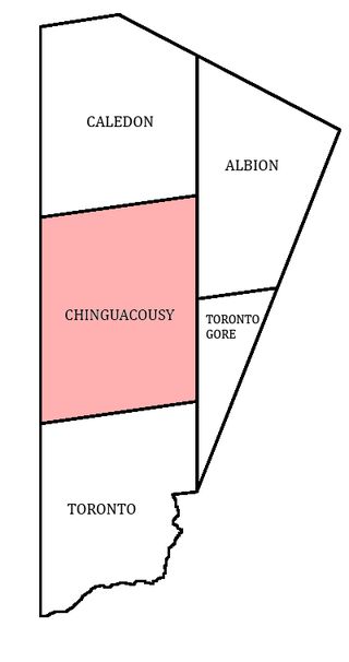
Chinguacousy Township is a former municipality and present-day geographic township in the Regional Municipality of Peel, Ontario, Canada. In 1974, when Peel County became the Region of Peel, the township was split in half, with the northern half becoming part of the town of Caledon, and the southern half, along with the township of Toronto Gore, joining the Town of Brampton, which was then promoted to a city.

Toronto Gore is a former incorporated and now geographic township in Ontario, Canada. It is today split between Mississauga and Brampton.
Vinegar Hill is an unincorporated community in Markham, Ontario, Canada bounded by Highway 7 to the north, Highway 407 to the south, and streets just west and east of Main Street South, bordered by the Rouge River. The name of the community is believed to be linked to a cider mill on the east side of the river valley or barrel makers that filled them with vinegar to test their straightness when rolling down Markham Road.

Bronte Creek is a waterway in the Lake Ontario watershed of Ontario Canada. It runs through Hamilton and Halton Region, with its source near Morriston, passing Bronte Creek Provincial Park, on its way to Lake Ontario at Bronte Harbour in Oakville, where the creek is also known as Twelve Mile Creek. Bronte takes its name from the title of the Duke of Bronté held by Horatio Nelson.

Bay Street is a lower city arterial road in Hamilton, Ontario, Canada. It starts at Inglewood Drive, just South of Aberdeen Avenue, as a collector road with only two lanes, then eventually becomes a six lane thoroughfare at its peak. Bay Street also passes through downtown Hamilton, where many high-rise buildings are found. Bay Street is a one-way street from Aberdeen Avenue to Cannon Street West. Bay Street continues as an arterial route to Strachan Street, where it is downgraded to a neighbourhood collector and eventually ends at a curb at Pier 4 Park at Burlington Street in the city's North End.
Winona is a small community in Southern Ontario that is officially part of the City of Hamilton, Ontario. It is roughly halfway between Buffalo (85 km) and Toronto (77 km) along the QEW. It has a proper population of 11,000.
Hope is the northernmost community in the city of Vaughan, in Ontario, Canada. The community is mostly rural, with farms scattered along the major thoroughfare. The heart of the settlement is at Keele Street and Kirby Road, with its eastern side stretching as far as Bathurst Street.

Eastgate Square is an indoor shopping mall in Stoney Creek, Hamilton, Ontario, Canada. The mall is bounded by Queenston Road (South), Centennial Parkway (East), Delawana Drive (North) and Kenora Avenue (West).

Highland Creek is a river in the Scarborough district of Toronto, Ontario, emptying into Lake Ontario at the eastern end of the Scarborough Bluffs. It is home to several species of fish including trout, carp, bass and salmon. It is a meandering river which, like most rivers in Toronto, travels through a glacial ravine formed after the last Ice Age. The Highland Creek watershed, including tributaries, is almost entirely contained within Scarborough.
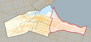
Hamilton East—Stoney Creek is a provincial electoral district in Ontario, Canada, that has been represented in the Legislative Assembly of Ontario since the 2007 provincial election.
Hamilton Mountain is a provincial electoral district in Ontario, Canada, that has been represented in the Legislative Assembly of Ontario since 1967. The riding is located in the Hamilton, Ontario region.