Gadhimai Municipality, Nepal

Last updated
Gadhimai Municipality

गढीमाई नगरपालिका

Gadhimai Nagarpalika
Nickname(s): 
Sarlahi Transit
Nepal adm location map.svg
Red pog.svg
Gadhimai Municipality
Location in Nepal
Coordinates: 26°56′23″N85°22′04″E / 26.93972°N 85.36778°E / 26.93972; 85.36778 Coordinates: 26°56′23″N85°22′04″E / 26.93972°N 85.36778°E / 26.93972; 85.36778
CountryFlag of Nepal.svg    Nepal
Province Province No. 2
Zone Narayani Zone
District Rautahat District
Government
  Type Mayor-Council government
   Mayor Shyam Yadav
   Deputy Mayor Shubhadra Gupta
Area
  Total49.44 km2 (19.09 sq mi)
Population
 (2011)
  Total40,410 [1]
  Ethnic Groups
Muslim, Yadav, Tharu, Mallaah, Brahmin, Bhumihar, Dom, Chamar,Thakur, Bania
  Religions
Islam, Hinduism
Time zone UTC+5:45 (NST)
Postal code
44513
Area code(s) 055
Geocode NP-TW
Main language Bajjika, Bhojpuri, Urdu, Hindi, Tharu, Maithili, Nepali
Website http://gadhimaimun.gov.np/

Gadhimai is a municipality in Rautahat district of Narayani zone, Nepal. It lies at the border of Rautahat district that links Sarlahi District over Bagmati River. It was formed by merging [2] former 6 Village development committees Gamhariya, samanpur, Sangrampur, Bahuwa Madanpur, Dharampur and Bariyarpur just before 2017 Nepalese local elections.

Contents

The current Member of the Legislative Assembly of Rautahat District Constituency 4(B) Pradesh Sabha and former VDC chairman Sheikh Abul Kalam Azad better known by his nickname Phool Babu is a resident. [3]

Geography

Aerial view of Terai plains near Gadhimai Municipality, Nepal Terai nepal.jpg
Aerial view of Terai plains near Gadhimai Municipality, Nepal

Gadhimai Municipality lies in plain of Terai region of Nepal.The land, here is fertile and humus containing.

Climate

Climate Zone [4] Elevation Range% of Area
Lower Tropical below 300 meters (1,000 ft)94.4%
Upper Tropical300 to 1,000 meters
1,000 to 3,300 ft.
 5.6%
Nepal topography. The green/yellow zones hold the Inner Terai valleys. Nepal topo en.jpg
Nepal topography. The green/yellow zones hold the Inner Terai valleys.

The Gadhimai Municipality has a humid, tropical climate. The mean annual rainfall at the Gadhimai Municipality was 2,214 mm (87.2 in) between 1995 and 2006. More than 80% of the total annual rainfall occurs during the monsoon season from June to September. Average temperatures ranged from 8.08 °C (46.54 °F) in January to 34.91 °C (94.84 °F) in June. [5]

In the past, the inner and outer Terai were a formidable barrier between Nepal and potential invaders from India because marshes and forests were infested by anopheline mosquitos that transmitted virulent strains of malaria, especially during the hot spring and rainy summer monsoon.

Gadhimai Municipality, 26°N, 85°E
Climate chart (explanation)
J
F
M
A
M
J
J
A
S
O
N
D
 
 
9
 
 
23
9
 
 
13
 
 
26
11
 
 
19
 
 
32
14
 
 
53
 
 
34
20
 
 
170
 
 
33
23
 
 
341
 
 
33
25
 
 
559
 
 
32
26
 
 
359
 
 
33
26
 
 
311
 
 
32
24
 
 
89
 
 
31
22
 
 
12
 
 
28
14
 
 
6
 
 
25
10
Average max. and min. temperatures in °C
Precipitation totals in mm
Source: Levoyageur

There are several differences between the climate on the eastern edge of the Terai at Biratnagar in Nepal and on the western edge of the Terai at Nepaljung in Nepal to that of Gadhimai Municipality in Nepal although they lies in same plain of Terai.

Education

Shree Shankar Gudar Campus, Samanpur

The origin of this campus goes back to its former "Shree Shankar Gudar Higher Secondary School" and further "Shree Shankar Gudar Secondary School", one of the oldest school in Nepal inaugurated when Samanpur was once limelight of whole Rautahat district. The institution has about 1000 students.

Shree Shankar Gudar Campus offers bachelor courses like Bachelor of Education, Bachelor of Arts at the moment while its former entities "Shree Shankar Gudar Higher Secondary School" offers 10+2 courses of Higher Secondary Education Board and "Shree Shankar Gudar Secondary School" offers up to 10th class of School Leaving Certificate (Nepal).

Shree Saraswati Higher Secondary School, Malahi Tola Chilmiliya

This school offers education up to 12th class and follow the curriculum of Government School of Nepal.

Madrasa Islahul Muslemeen, Gamhariya

The eldest Islamic school of Nepal "Madrasa Islahul Muslemeen" is situated in Gamhariya which was founded by "Sheikh Hajee Alibaksh". Later his son "Sheikh Hajee Sujaeet" added some more infrastructures. The great-grand son, Phool Babu, of the founder of this Madrasa is currently the chief of this Islamic School.

The Madrasa has around 700 students. Among them around 100 are boarders mostly from Rautahat District, Sarlahi District and Bihar (India).The curriculum of study is not only Islamic study like "Deene Taleem" but also Mathematics and Languages like English, Arabic, Persian (Farsi), Urdu, Hindi and Nepali are taught. It is said that there is no single family in this village who don't have at least one Mawlānā (Graduate of religious Institution) and also boast for highest number of Mawlānā in one VDC in whole Nepal. [6] [7]


There are some other schools in this municipality which offer education up to 10th class and follow the curriculum of Government School of Nepal.

Transport

This municipality lies in the middle of Rautahat District and bordering Sarlahi District and is the center of oldest highway of Rautahat district called "Rajaiya Sadak" which still connects Rautahat District headquarters Gaur and East-West Highway terminal Chandrapur.

East side it is connected to Sarlahi District via several sub localities over Bagmati River whereas on the west side It is connected with new Highway called "Gaur-Chandranigahpur Highway" through Garuda Municipality that links this municipality to capital of Nepal, Kathmandu, and other major cities like Birgunj, Janakpurdham, Pokhara, Biratnagar, Nepalgunj, Bharatpur, etc. via East-West Highway.

As it is connected to Rautahat District headquarters Gaur via "Rajaiya Sadak" as well as via "Gaur-Chandranigahpur Highway" and Gaur is also border of Nepal that links India via Bairgania, one can reach to all major cities of India using Indian Railways available at Bairgania.

Land transportation like Tanga, Rickshaw, Jeep, Bus is available to reach Garuda Municipality.

The nearest domestic airport, Simara Airport, is in Simra while nearest International airport, Nijgadh International Airport, is under construction in Nijgadh. Currently passengers use Tribhuvan International Airport located in capital of Nepal, Kathmandu, for International flight.

it is 20 km north of Gaur and 20 km south of Chandrapur.

Economy

Its one locality Samanpur was major financial center in Rautahat district. The others were Gaur, Pipara, Kathariya and Chandranigahpur. Due to flooding problem from Bagmati River as well as creation of new highway "Gaur-Chandranigahpur Highway" and lack of attention from central government its status got degraded day by day.

There is another emerging market in Bariyarpur(Malahi Bazar).

The major economy of this municipality is farming. Sugarcane, Paddy, Wheat, Mustard, Dal, Vegetables, Fruits, etc. are the major production of this municipality. The other economy is the remittance from the people working mostly in Kathmandu, India and Gulf Countries.

Culture

The culture of this Municipality is the mix of Muslim as well as Hindu community. The municipality got its name from one of the Mela held in its locality Sangrampur(Sundarpur).

Communication

Nepal Telecom and Ncell have network coverage. Ncell has a 3G network for a long time there but now Nepal Telecom also has a 3G network.

Related Research Articles

Rautahat District, a part of Province No. 2, is one of the seventy-seven districts of Nepal. The district headquarter is Gaur, including municipalities like Garuda, Chandrapur, Paroha, covers an area of 1,126 km² and had a population of 545,132 in 2001 and 686,722 in 2011. This district has a total of 2 VDCs and 16 municipalities. Among other districts, Rautahat has the largest percent of Muslims in Nepal, about 19.465%. most muslim densely Village Bairiya is an example for secularism in Nepal.that's why the peoples also called it's The Peaceful Village. Sri Ram Sugar Mill is located in Garuda and the famous Hindu temple in Rautahat district is in Shivnagar and the temple is run by giri family.And also, the historical temple of Goddess Durga is in one of the most developed VDC of the district(Matsari). Matsari is known to be the only village of Narayani Zone to have 100% literacy rate .And, also Late Shri Gulab Narayan Jha, the first person to represent madhesis in politics, was permanent resident of this Village.

Sarlahi District District in Province No. 2, Nepal

Sarlahi, a part of Province No. 2, is one of the seventy-seven districts of Nepal. According to new laws, combination of more than 2 or 4 villages makes a municipality, which covers an area of 1,259 km2 (486 sq mi) and had a population of 635,701 in 2001 and 769,729 in 2011.

Gaur, Nepal Capital of Nepal

Gaur is a municipality and headquarters of Rautahat district of Narayani zone, Nepal. It lies at the border of Nepal that links India via Bairgania and has a customs checkpoint.

Sisautiya Village development committee in Janakpur Zone, Nepal

Sisautiya सिसौटिया is a small and most populated village in the southernmost part of Nepal commonly known as Madhesh or Terai. Sisautiya is 9km north of the Indian border, 18km south from Brahathawa municipality 9km west from district headquarters Malangawa. It is located at 26°52'0N 85°34'0E with an altitude of 79 metres(262 feet) There is a customs checkpoint at the border crossing. It is part of the Sarlahi district and the Janakpur zone. It forms the main part of the Sisautiya village development committee. At the time of the 2011 Nepal census it had a population of 13,729 people living in 2259 individual households.

Malangwa Municipality in Province No. 2, Nepal

Malangwa is a town, a municipality, and the headquarters of Sarlahi District in Province No. 2 of Nepal. The district's oldest municipality, it is in parliamentary constituency 2. On the Mahendra Highway 24 kilometres (15 mi) south of Nawalpur, a small highway side town. It is situated at an altitude of 79 meters (262 feet), Malangwa is near the Indian border at Sonbarsa. There is a customs checkpoint at the border crossing.

Gamhariya, Sarlahi Village Development Committee in Nepal

Gamhariya is a Village Development Committee in Sarlahi District in the Janakpur Zone of south-eastern Nepal. At the time of the 2011 Nepal census it had a population of 8000 people residing in 674 individual households. It has two sub villages small Palsi which is hardly 1 km east of the village and other is called Ganesiya which is located at south of the village which is also 1 km. North Ganesiya is associate with Gamhariya identified by ward no 6 and south part is located in Musaili VDC.

Hariwan Municipality in Janakpur Zone, Nepal

Hariwan Municipality is one of the new Municipality declared by Nepal Government on May 18, 2014. It is situated in Sarlahi District Janakpur zone, Nepal. It is formed by joining four contemporary VDCs namely Atrouli, Sasapur, Ghurkauli and Harion VDCs that spreads to 88.1 sq. km. It has been divided into 11 wards with administration center in Harion Bazar. According to Nepal Population Census 2011, this municipality has total population of 42,783.

Lalbandi Municipality in Janakpur Zone, Nepal


Lalbandi is a Municipality in Sarlahi District in the Janakpur Zone of south-eastern Nepal. The municipality was established on 18 May 2014 by merging the existing Jabdi, Lalbandi and Pattharkot VDCs. At the time of the 2011 Nepal Census it had a population of 59,395 people living in 3295 individual households.There are 17 wards in this municipality.It is the largest municipality in Sarlahi district.The office of this municipality is in ward no.6 Located in the Lalbandi.Lalbandi Bazar, located on the East West Mahendra highway, is one of the main trading areas within the municipal area.Bordering East Ishwarpur Municipality, West Hariwan and Haripur Municipality, North Sindhuli District and bordering Haripur and Ishwarpur in the south, Lalbandi Bazar is the main trading site of the district.

Pipariya, Sarlahi Village development committee in Janakpur Zone, Nepal

Pipariya is a village development committee in Sarlahi District in the Janakpur Zone of south-eastern Nepal. At present it's part of Kabilasi Municipality. It includes 2 Wards of Kabilasi i.e 1&2. According to the CBS 2011 it is carrying 1218 households and total population 6991 including 3581 Males and 3410 Females.

Bahuwa Madanpur Village development committee in Narayani Zone, Nepal

Bahuwa Madanpur was a village development committee in Rautahat District in the Narayani Zone of south-eastern Nepal.

Bariyarpur, Rautahat Village development committee in Narayani Zone, Nepal

Bariyarpur was a village development committee in Rautahat District in the Narayani Zone of south-eastern Nepal.

Chandrapur Municipality Municipality in Narayani Zone, Nepal

Chandrapur Municipality other names Chandranigahapur locally known as Chapur is a Municipality in Rautahat District in the Narayani Zone in Province No. 2 of southern Nepal. The municipality was established on 18 May 2014 by merging Chandranigahapur, Judibela, Paurai, Santpur Matioun, Dumariya Matioun VDCs.

Dharampur was a village development committee in Rautahat District in the Narayani Zone of south-eastern Nepal.

Gamhariya, Nepal Village development committee in Narayani Zone, Nepal

Gamhariya was a village development committee in Rautahat District in the Narayani Zone of south-eastern Nepal.

Garuda Bairiya Village development committee in Narayani Zone, Nepal

Garuda Bairiya is a village development committee in Rautahat District in the Narayani Zone of south-eastern Nepal. At the time of the 1991 Nepal census it had a population of 1878 people living in 313 individual households. By 2012, the VDC had largely increased in size and its population reached more than 10000 approximately. The village is divided into two areas: the bajar and the gaun. Birendra highway passes through the Bajar which has Chandranigahpur on the north connecting the East-West highway and Gaur on the south which is on the Nepal-India Border. The VDC gained its fortune after the Birendra Highway was constructed. After the highway construction, developments and infrastructures followed around the VDC areas. In ancient time, the owner of Garuda gaun is Mathur Chaudhry In 1994 A.D. Shree Ram Sugar Mill was erected in Garuda. With the establishment of the sugar industry, farmers had opportunity to open business with the factory. They increased their sugarcane farming and sold it to the factory in their backyard. The factory provided jobs and opened sources of business in the VDC. Hence, today the VDC is a fast-growing town with every business one can name. It is the center of business in the area with few banks, five-six petrol pumps, hundreds of Grocery stores, handful of Shopping centers, small granary and Eating-oil mills, shoes factory, a High school, several restaurants, clinics and Elaka police Station. Many of the great businessman are in Garuda. Jaiswal,Sharma,etc. are famous businessman of the Garuda. The VDC also has a movie theatre. Transport is available throughout all day and sparsely at the night. Approximately 50% of the people are involved directly in farming and the other 50% in Business or other traditional works.

Samanpur Village development committee in Narayani Zone, Nepal

Samanpur was a village development committee in Rautahat District in the Narayani Zone of south-eastern Nepal.

Sangrampur, Rautahat Village development committee in Narayani Zone, Nepal

Sangrampur was a village development committee in Rautahat District in the Narayani Zone of south-eastern Nepal.

Garuda Municipality Municipality in Narayani Zone, Nepal

Garuda is a Municipality in Rautahat District in the Narayani Zone of south-eastern Nepal. It is a newly created municipality by merging 7 former Village development committees namely Garuda Bairiya, Malahi, Basbiti Jingadiya, Gedahiguthi, Jayanagar, Mahamadpur and Pothiyahi [1].

Province No. 2 Province of Nepal

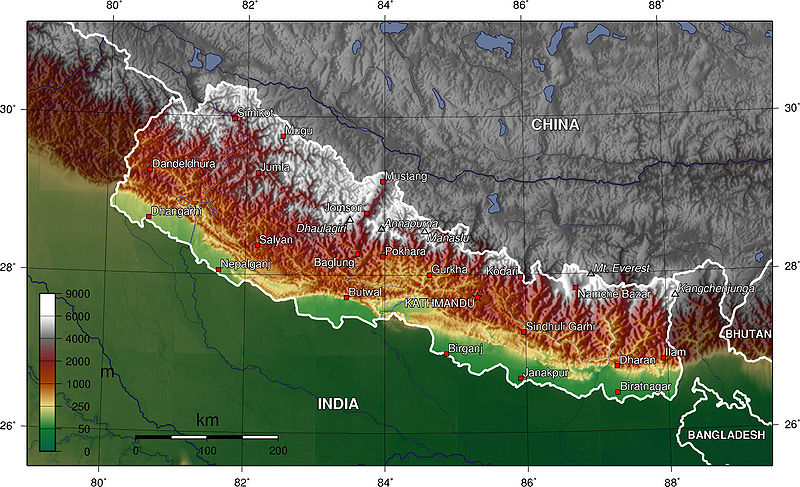
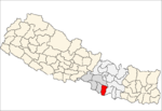
Province No. 2 is a province in the southeastern region of Nepal that was formed after the adoption of the Constitution of Nepal. It is Nepal's second most populous province, and smallest province by area. It borders Province No. 1 to the east, Province No. 3 to the north, and India to the south. It has an area of 9,661 km2 (3,730 sq mi) with a population of 5,404,145 per the 2011 Census of Nepal, making it most densely populated province of Nepal.

Phool Babu

Sheikh Abul Kalam Azad better known by his nickname Phool Babu is a high profile Nepalese politician, Social Worker, current Member of the Legislative Assembly of Rautahat District Constituency 4(B) Pradesh Sabha and former VDC chairman(Nepali: अध्यक्ष) of Gamhariya, Nepal.

References

  1. Central Bureau Statistics: National Population and Housing Census 2011 (p. 54, nr 33). Archived July 31, 2013, at the Wayback Machine
  2. Gadhimai Municipality, "Merging of VDCs", 2017
  3. Pradesh Sabha, "Election 2017", 7 December 2017
  4. The Map of Potential Vegetation of Nepal - a forestry/agroecological/biodiversity classification system (PDF), Forest & Landscape Development and Environment Series 2-2005 and CFC-TIS Document Series No.110, 2005, ISBN   87-7903-210-9 , retrieved Nov 22, 2013
  5. Department of Hydrology and Meteorology (2006). Climatological Records of Nepal (Several Volumes), Babarmahal, Kathmandu.
  6. "Islamic Centers". Archived from the original on 2013-07-03.
  7. "Gamhariya Parsa". Google Maps. Retrieved 26 May 2013.

This page was created by Fakhruddin Shekh