
Chestnut Hill is a neighborhood in the Northwest Philadelphia section of Philadelphia, Pennsylvania, United States. It is known for the high incomes of its residents and high real estate values, as well as its private schools.

The Panama–California Exposition was a world exposition held in San Diego, California, between January 1, 1915, and January 1, 1917. The exposition celebrated the opening of the Panama Canal, and was meant to tout San Diego as the first United States port of call for ships traveling north after passing westward through the canal. The fair was held in San Diego's large urban Balboa Park. The park held a second Panama-California exposition in 1935.

Mission Valley is a wide river valley trending east–west in San Diego, California, United States, through which the San Diego River flows to the Pacific Ocean. For planning purposes the City of San Diego divides it into two neighborhoods: Mission Valley East and Mission Valley West.

The San Diego Trolley is a light rail system serving San Diego County, California. The trolley's operator, San Diego Trolley, Inc., is a subsidiary of the San Diego Metropolitan Transit System (MTS). The trolley operates as a critical component of MTS, with connections to and integrated travel tickets with the local bus systems.

The San Diego Electric Railway (SDERy) was a mass transit system in San Diego County, California, United States. The system utilized 600 volt direct current streetcars and buses.

The Arroyo Seco, meaning "dry stream" in Spanish, is a 24.9-mile-long (40.1 km) seasonal river, canyon, watershed, and cultural area in Los Angeles County, California. The area was explored by Gaspar de Portolà who named the stream Arroyo Seco as this canyon had the least water of any he had seen. During this exploration he met the Chief Hahamog-na (Hahamonga) of the Tongva Indians.

The Colorado Street Bridge is a historic concrete arch bridge spanning the Arroyo Seco in Pasadena, California.

Barrio Logan is a neighborhood in south central San Diego, California. It is bordered by the neighborhoods of East Village and Logan Heights to the north, Shelltown and Southcrest to the east, San Diego Bay to the southwest, and National City to the southeast. Interstate 5 forms the northeastern boundary. The Barrio Logan Community Plan Area comprises approximately 1,000 acres, of which slightly more than half is under the jurisdiction of the Port of San Diego or the United States Navy rather than the city of San Diego. The community is subject to the California Coastal Act. Though located near the city's central core, it has long been considered part of Southeast San Diego by many locals, being directly southeast of downtown San Diego, and with previous historical records labeling it as part of "Western Southeast San Diego."

University Heights is a neighborhood in San Diego, California, centered on Park Boulevard and Adams Avenue. University Heights is bounded on the west and north by the edge of the mesa overlooking Mission Valley, the southern boundary is Lincoln Avenue, and the eastern boundary is Texas Street.
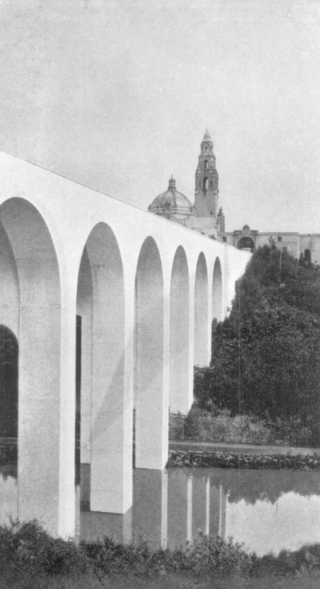
The Cabrillo Bridge is a historic bridge in San Diego, California, providing pedestrian and light automotive access between Balboa Park and the uptown area of San Diego. It was built for the Panama–California Exposition of 1915. The bridge was nominated for the National Register of Historic Places in 1976 and was named a Local Historic Civil Engineering Landmark by the American Society of Civil Engineers in 1986.

Santa Fe Depot is a union station in San Diego, California, built by the Atchison, Topeka and Santa Fe Railway to replace the small Victorian-style structure erected in 1887 for the California Southern Railroad Company. The Spanish Colonial Revival style station is listed on the National Register of Historic Places and is a San Diego Historic Landmark. Its architecture, particularly the signature twin domes, is often echoed in the design of modern buildings in downtown San Diego.

Kensington is a neighborhood in San Diego, California. Its borders are defined by Interstate 15 to the west, Interstate 8 to the north, Fairmount Avenue to the east, and El Cajon Boulevard to the south. Its neighboring communities are Normal Heights to the west, and City Heights to the south. Kensington is part of San Diego City Council District 9. In the United States House of Representatives, Kensington is in California's 53rd congressional district, represented by Democrat Sara Jacobs. Due to redistricting, it will become part of the 51st district after the 2022 congressional election.

Downtown San Diego is the central business district of San Diego, California, the eighth largest city in the United States. It houses the major local headquarters of the city, county, state, and federal governments. The area comprises seven districts: Gaslamp Quarter, East Village, Columbia, Marina, Cortez Hill, Little Italy, and Core.

Old Town Transit Center, also known as San Diego–Old Town station, or Old Town San Diego station, is an intermodal transportation station in the Old Town neighborhood of San Diego, California. It is served by Amtrak's Pacific Surfliner, the COASTER commuter rail service, and the San Diego Trolley, as well as numerous San Diego Metropolitan Transit System bus lines.

Streetcars and interurbans operated in the Maryland suburbs of Washington, D.C., between 1890 and 1962.

Streetcars or trolley(car)s were once the chief mode of public transit in hundreds of North American cities and towns. Most of the original urban streetcar systems were either dismantled in the mid-20th century or converted to other modes of operation, such as light rail. Today, only Toronto still operates a streetcar network essentially unchanged in layout and mode of operation.
The Washington Railway and Electric Company (WREC) was the larger of the two major streetcar companies in Washington, D.C., and its Maryland suburbs in the early decades of the 20th century.
30th Street is a major north–south road in San Diego, California, on the east side of Balboa Park. It connects several of the densest urban communities of downtown San Diego and has a high rate of pedestrian activity. In recent years, 30th Street has become known nationally for its prominent craft beer culture.

Balboa Park is a 1,200-acre (490 ha) historic urban cultural park in San Diego, California. Placed in reserve in 1835, the park's site is one of the oldest in the United States dedicated to public recreational use. The park hosts various museums, theaters, restaurants, and the San Diego Zoo. It is managed and maintained by the Parks and Recreation Department of the City of San Diego.


